110.232.133.191 - IP Lookup: Free IP Address Lookup, Postal Code Lookup, IP Location Lookup, IP ASN, Public IP
Country:
Region:
City:
Location:
Time Zone:
Postal Code:
ISP:
ASN:
language:
User-Agent:
Proxy IP:
Blacklist:
IP information under different IP Channel
ip-api
Country
Region
City
ASN
Time Zone
ISP
Blacklist
Proxy
Latitude
Longitude
Postal
Route
db-ip
Country
Region
City
ASN
Time Zone
ISP
Blacklist
Proxy
Latitude
Longitude
Postal
Route
IPinfo
Country
Region
City
ASN
Time Zone
ISP
Blacklist
Proxy
Latitude
Longitude
Postal
Route
IP2Location
110.232.133.191Country
Region
kanagawa
City
odawara
Time Zone
Asia/Tokyo
ISP
Language
User-Agent
Latitude
Longitude
Postal
ipdata
Country
Region
City
ASN
Time Zone
ISP
Blacklist
Proxy
Latitude
Longitude
Postal
Route
Popular places and events near this IP address

Odawara Station
Railway station in Odawara, Kanagawa Prefecture, Japan
Distance: Approx. 844 meters
Latitude and longitude: 35.25638889,139.155
Odawara Station (小田原駅, Odawara-eki) is a junction and interchange railway station located in the city of Odawara, Kanagawa, Japan, operated jointly by the East Japan Railway Company (JR East) and Central Japan Railway Company (JR Tōkai). It is a gateway station to the Hakone area. It is also a freight depot for the Japan Freight Railway Company.

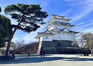
Odawara Castle
Reconstructed castle in Odawara, Kanagawa Prefecture, Japan
Distance: Approx. 341 meters
Latitude and longitude: 35.25083333,139.15361111
Odawara Castle (小田原城, Odawara-jō) is a reconstructed Japanese castle in the city of Odawara in Kanagawa Prefecture, Japan. The current donjon (keep) was constructed out of reinforced concrete in 1960 on a stone foundation of the former donjon, torn down from 1870–1872 during the Meiji Period. There has been fortifications at or around the castle's current site since the Kamakura Period (1185–1333).

Siege of Odawara (1569)
1569 battle in Japan
Distance: Approx. 337 meters
Latitude and longitude: 35.251,139.1535
The second Siege of Odawara took place in 1569. Takeda Shingen attacked Odawara Castle, as a response to Hōjō's intervention into Shingen invasion of Suruga Province.
Odawara
Special city in Kantō, Japan
Distance: Approx. 0 meters
Latitude and longitude: 35.25,139.15
Odawara (小田原市, Odawara-shi) is a city in Kanagawa Prefecture, Japan. As of 1 June 2021, the city had an estimated population of 188,482 and a population density of 1,700 persons per km2. The total area of the city is 113.79 square kilometres (43.93 sq mi).

Siege of Odawara (1561)
1561 siege in Japan
Distance: Approx. 341 meters
Latitude and longitude: 35.25083056,139.15361111
In the 1561 siege of Odawara, a battle of Japan's Sengoku period, Uesugi Kenshin attacked Odawara castle. This was the first of several sieges which would befall Odawara castle, the home castle of the Hōjō clan.

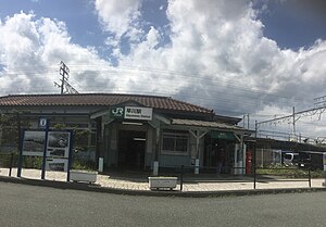
Hayakawa Station
Railway station in Odawara, Kanagawa Prefecture, Japan
Distance: Approx. 1286 meters
Latitude and longitude: 35.239085,139.145368
Hayakawa Station (早川駅, Hayakawa-eki) is a passenger railway station located in the city of Odawara, Kanagawa Prefecture, Japan, operated by the East Japan Railway Company (JR East).
Odawara Women's Junior College
Distance: Approx. 96 meters
Latitude and longitude: 35.24916667,139.14972222
Odawara Women's Junior College (小田原女子短期大学, Odawara joshi tanki daigaku) is a private women's junior college in Odawara Kanagawa Prefecture, Japan. Established in 1956, the school specializes in nutrition studies and child care.

Midorichō Station
Railway station in Odawara, Kanagawa Prefecture, Japan
Distance: Approx. 1344 meters
Latitude and longitude: 35.25961944,139.15894167
Midorichō Station (緑町駅, Midorichō-eki) is a passenger railway station located in the city of Odawara, Kanagawa Prefecture, Japan, operated by the Izuhakone Railway.

Kazamatsuri Station
Railway station in Odawara, Kanagawa Prefecture, Japan
Distance: Approx. 1946 meters
Latitude and longitude: 35.24626111,139.12908889
Kazamatsuri Station (風祭駅, Kazamatsuri-eki) is a railway station on the Hakone Tozan Line located in Odawara, Kanagawa Prefecture, Japan. It is 3.2 rail kilometers from the line's terminus at Odawara Station.
Hakone-Itabashi Station
Railway station in Odawara, Kanagawa Prefecture, Japan
Distance: Approx. 693 meters
Latitude and longitude: 35.24544167,139.14480556
Hakone-Itabashi Station (箱根板橋駅, Hakone-Itabashi-eki) is a railway station on the Hakone Tozan Line located in Odawara, Kanagawa Prefecture, Japan. It is 1.7 rail kilometers from the line's terminus at Odawara Station.

Hōtoku Ninomiya Shrine
Shrine in Odawara, Kanagawa
Distance: Approx. 255 meters
Latitude and longitude: 35.25,139.1528
Hōtoku Ninomiya Shrine (報徳二宮神社) is a Japanese Shinto shrine dedicated to Ninomiya Sontoku (二宮尊徳) and is located in the City of Odawara in Kanagawa prefecture, Japan.

Haya River (Kanagawa)
Distance: Approx. 1156 meters
Latitude and longitude: 35.23982778,139.14746111
The Haya River (Japanese: 早川 = Hayakawa, literally a fast-flowing river ) is a river that flows in Hakone and Odawara, Kanagawa, Japan. It is a 26 kilometres (16 mi) long river, starting from the Kojiri Water Gate (湖尻水門) at the northern tip of Lake Ashi, gathering rain and hot spring water as it flows in the Sengoku, the Mount Hakone caldera, running down beside the towns of Hakone Hot Springs, and emptying near Odawara Fishing Port (35°14′23.38″N 139°8′50.86″E) into Sagami Bay of the Pacific Ocean. Lake Ashi is not the source of the Haya River, because it is drained through the Fukara Water Gate to the Fukara Aqueduct, completed in 1676, which leads to Shizuoka Prefecture.
Weather in this IP's area
clear sky
8 Celsius
6 Celsius
8 Celsius
8 Celsius
1021 hPa
54 %
1021 hPa
992 hPa
10000 meters
1.8 m/s
1.95 m/s
357 degree
5 %

