Country:
 Australia
Region:
City:
Latitude and Longitude:
Time Zone:
Postal Code:
IP information under different IP Channel
ip-api
Country
Region
City
ASN
Time Zone
ISP
Blacklist
Proxy
Latitude
Longitude
Postal
Route
IPinfo
Country
Region
City
ASN
Time Zone
ISP
Blacklist
Proxy
Latitude
Longitude
Postal
Route
MaxMind
Country
Region
City
ASN
Time Zone
ISP
Blacklist
Proxy
Latitude
Longitude
Postal
Route
Luminati
Country
AURegion
vic
City
melbourne
ASN
Time Zone
Australia/Melbourne
ISP
TPG Telecom Limited
Latitude
Longitude
Postal
db-ip
Country
Region
City
ASN
Time Zone
ISP
Blacklist
Proxy
Latitude
Longitude
Postal
Route
ipdata
Country
Region
City
ASN
Time Zone
ISP
Blacklist
Proxy
Latitude
Longitude
Postal
Route
Popular places and events near this IP address

Toorak
Suburb of Melbourne, Victoria, Australia
Distance: Approx. 259 meters
Latitude and longitude: -37.841,145.018
Toorak () is a suburb of Melbourne, Victoria, Australia, 5 km (3.1 mi) south-east of Melbourne's Central Business District, located within the City of Stonnington local government area. Toorak recorded a population of 12,817 at the 2021 census. The name Toorak has become synonymous with wealth and privilege, the suburb long having the reputation of being Melbourne's most elite, and ranking among the most prestigious in Australia.

Heyington railway station
Railway station in Melbourne, Australia
Distance: Approx. 553 meters
Latitude and longitude: -37.83472,145.02266
Heyington railway station is a commuter railway station on the Glen Waverley line, which is part of the Melbourne railway network. It serves the eastern suburb of Toorak, in Melbourne, Victoria, Australia. Heyington station is a ground level staffed station, featuring two side platforms.

St Kevin's College, Melbourne
Catholic school in Melbourne, Australia
Distance: Approx. 553 meters
Latitude and longitude: -37.83611111,145.02472222
St Kevin's College is a private Catholic primary and secondary school for boys located in Melbourne, Victoria, Australia. The college has five campuses, three of which are in the suburb of Toorak, the fourth in Richmond, and the fifth being a sport campus located behind Stockland Tooronga. The school owned a campsite 'Silver Creek' in the town of Flowerdale which was completely destroyed by the Black Saturday bushfires.
Scotch College, Melbourne
School in Hawthorn, Victoria, Australia
Distance: Approx. 1018 meters
Latitude and longitude: -37.83416667,145.02944444
Scotch College is a private, Presbyterian day and boarding school for boys, located in Hawthorn, an inner-eastern suburb of Melbourne, Victoria, Australia. The college was established in 1851 as The Melbourne Academy in a house in Spring Street, Melbourne, by the Free Presbyterian Church of Victoria at the urging of James Forbes. It is the oldest extant secondary school in Victoria and celebrated its sesquicentenary in 2001.

Kooyong Stadium
Australian tennis venue
Distance: Approx. 1080 meters
Latitude and longitude: -37.83833333,145.03194444
Kooyong Stadium, at the Kooyong Lawn Tennis Club, is an Australian tennis venue, located in the Melbourne suburb of Toorak, adjacent to the namesake suburb of Kooyong. The stadium was built in 1927, and has undergone several renovations. It has a seating capacity of slightly more than 5,000.
Loreto Mandeville Hall
School in Australia
Distance: Approx. 1082 meters
Latitude and longitude: -37.84777778,145.01416667
Loreto Mandeville Hall Toorak is an independent Roman Catholic single-sex primary and secondary day school for girls, located in Toorak, a suburb of Melbourne, Victoria, Australia. It is one of many Loreto schools around the world, established by the Loreto Sisters founded some 400 years ago by Mary Ward. The Loreto Sisters purchased Mandeville Hall in 1924 having previously established schools in Ballarat and Albert Park with encouragement from St Mary MacKillop.
St Catherine's School, Toorak
Independent, day & boarding school in Toorak, Victoria, Australia
Distance: Approx. 153 meters
Latitude and longitude: -37.83805556,145.02083333
St Catherine's School is an independent and non-denominational Christian day and boarding school for girls, located in Toorak, an inner south-eastern suburb of Melbourne, Victoria, Australia. Established in 1896 as Castlemaine Ladies' College, the school has a non-selective enrolment policy. As for 2006 the school catered for approximately 730 students from pre-school to Year 12, including 80 boarders, on a 2.9 hectare campus.

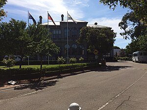
Toorak House
Mansion in Melbourne, Australia
Distance: Approx. 139 meters
Latitude and longitude: -37.839153,145.018115
Toorak House is a mansion located in Melbourne, Australia built in 1849 by well-known Melbourne merchant James Jackson. It is notable for its use as Melbourne's first Government House and having inspired the name for the suburb of Toorak. Jackson is believed to have borrowed from Woiwurrung language, with words of similar pronunciation, meaning either black crow or reedy swamp.
MacRobertson Bridge
Bridge in Australia
Distance: Approx. 1146 meters
Latitude and longitude: -37.830446,145.012638
The MacRobertson Bridge is a road bridge that carries Grange Road from Toorak on the south bank into Burnley, over the Yarra River and the Monash Freeway in Melbourne, Victoria, Australia. The first river crossing at the site was Twickenham Ferry, which conveyed passengers and was founded by waterman Jesse Barrow in 1880. it was named for the Twickenham Ferry in London.
Richmond Park railway station
Former railway station in Victoria, Australia
Distance: Approx. 1014 meters
Latitude and longitude: -37.83,145.02027778
Richmond Park was a railway station of the Darling (now Glen Waverley) line in Melbourne, Australia. The station was situated between Burnley railway station and Heyington railway station. The station was built 24 March 1890, with the rest of the line to Darling, but never opened.
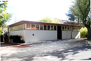
Roy Grounds House
House & apartments in Victoria, Australia
Distance: Approx. 704 meters
Latitude and longitude: -37.835435,145.01318
The Roy Grounds House, at 24 Hill Street, Toorak in Melbourne, Australia, was designed by Sir Roy Grounds as his own home for his wife Betty and himself. It is celebrated as one of the most outstanding works of modernist domestic architecture of the mid 20th century in Victoria, a time of great experimentation, and one of the most notable designs by Roy Grounds, one of the most well known and influential modern architects in Victoria.
Electoral district of Toorak
Former state electoral district of Victoria, Australia
Distance: Approx. 859 meters
Latitude and longitude: -37.84,145.01
The electoral district of Toorak was an electorate of the Victorian Legislative Assembly in the British colony and later Australian state of Victoria.
Weather in this IP's area
clear sky
11 Celsius
10 Celsius
9 Celsius
12 Celsius
1018 hPa
64 %
1018 hPa
1012 hPa
10000 meters
4.29 m/s
11.82 m/s
17 degree
06:41:44
19:31:50