Country:
 Australia
Region:
City:
Latitude and Longitude:
Time Zone:
Postal Code:
IP information under different IP Channel
ip-api
Country
Region
City
ASN
Time Zone
ISP
Blacklist
Proxy
Latitude
Longitude
Postal
Route
IPinfo
Country
Region
City
ASN
Time Zone
ISP
Blacklist
Proxy
Latitude
Longitude
Postal
Route
MaxMind
Country
Region
City
ASN
Time Zone
ISP
Blacklist
Proxy
Latitude
Longitude
Postal
Route
Luminati
Country
AURegion
vic
City
melbourne
ASN
Time Zone
Australia/Melbourne
ISP
TPG Telecom Limited
Latitude
Longitude
Postal
db-ip
Country
Region
City
ASN
Time Zone
ISP
Blacklist
Proxy
Latitude
Longitude
Postal
Route
ipdata
Country
Region
City
ASN
Time Zone
ISP
Blacklist
Proxy
Latitude
Longitude
Postal
Route
Popular places and events near this IP address

Brunswick railway station, Melbourne
Railway station in Melbourne, Australia
Distance: Approx. 1714 meters
Latitude and longitude: -37.7677,144.9597
Brunswick railway station is a commuter railway station on the Upfield line, which is part of the Melbourne railway network. It serves the northern suburb of Brunswick, in Melbourne, Victoria, Australia. Brunswick station is a ground level unstaffed station, featuring two side platforms.

Anstey railway station
Railway station in Melbourne, Australia
Distance: Approx. 1389 meters
Latitude and longitude: -37.761074,144.960609
Anstey railway station is a commuter railway station on the Upfield line, which is part of the Melbourne railway network. It serves the northern suburb of Brunswick, in Melbourne, Victoria, Australia. Anstey station is a ground level unstaffed station, featuring two side platforms.

Moreland railway station
Railway station in Melbourne, Australia
Distance: Approx. 1454 meters
Latitude and longitude: -37.7545,144.9619
Moreland railway station is a commuter railway station on the Upfield line, which is part of the Melbourne railway network. It serves the northern suburb of Coburg, in Melbourne, Victoria, Australia. Moreland station is an elevated unstaffed station, with two side platforms.

Brunswick West, Victoria
Suburb of Melbourne, Victoria, Australia
Distance: Approx. 504 meters
Latitude and longitude: -37.761,144.943
Brunswick West is an inner-city suburb in Melbourne, Victoria, Australia, 6 km (3.7 mi) north of Melbourne's Central Business district, located within the City of Merri-bek local government area. Brunswick West recorded a population of 14,746 at the 2021 census. Brunswick West adjoins Parkville to the south, Moonee Ponds at the Moonee Ponds Creek to the west, Pascoe Vale South and Coburg along Moreland Road to the north, and Brunswick along Grantham, Pearson and Shamrock Streets to the east.

Pascoe Vale South, Victoria
Suburb of Melbourne, Victoria, Australia
Distance: Approx. 1700 meters
Latitude and longitude: -37.7431,144.9377
Pascoe Vale South is an inner suburb in Melbourne, Victoria, Australia, 8 km (5.0 mi) north of Melbourne's Central Business District, located within the City of Merri-bek local government area. Pascoe Vale South recorded a population of 10,534 at the 2021 census. Pascoe Vale South adjoins Brunswick West to the south, Strathmore and the Moonee Ponds Creek to the west, Coburg to the east, and Pascoe Vale to the north.
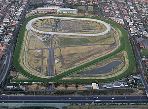
Moonee Valley Racecourse
Horse racing track in Melbourne, Victoria, Australia
Distance: Approx. 1598 meters
Latitude and longitude: -37.765444,144.931002
Moonee Valley Racecourse, currently marketed as The Valley, is a horse-racing track in Moonee Ponds, Melbourne, Victoria Australia.

City of Brunswick
Local government area in Victoria, Australia
Distance: Approx. 1748 meters
Latitude and longitude: -37.767,144.961
The City of Brunswick was a local government area in the inner-northern suburbs of Melbourne, Victoria, Australia. It comprised the suburbs of Brunswick, Brunswick East and Brunswick West. It ceased to exist on 22 June 1994, when its council was disbanded by the Kennett Government and replaced with appointed commissioners, who oversaw its amalgamation with the City of Coburg and parts of the City of Broadmeadows, to create the City of Moreland (now City of Merri-bek).
Electoral district of Brunswick West
Former electoral district in the Victoria, Australia
Distance: Approx. 1141 meters
Latitude and longitude: -37.76666667,144.95
The electoral district of Brunswick West was an electorate of the Legislative Assembly in the Australian state of Victoria.

Brunswick tram depot
Tram depot in metropolitan Melbourne, Victoria, Australia
Distance: Approx. 1515 meters
Latitude and longitude: -37.7572,144.9629
Brunswick tram depot is located on Sydney Road, Brunswick, a suburb of Melbourne, Victoria, Australia. It opened on 26 April 1936 in conjunction with the electrification of the Brunswick and North Melbourne Cable tram line. Operated by Yarra Trams, it is one of eight tram depots on the Melbourne tram network.

Electoral district of East Bourke Boroughs
Former state electoral district of Victoria, Australia
Distance: Approx. 1123 meters
Latitude and longitude: -37.75833333,144.95833333
East Bourke Boroughs was an electoral district of the Legislative Assembly in the Australian state of Victoria from 1859 to 1904. The district was defined in the Electoral Districts Act of 1858 as: Commencing at a point on the east bank of the Moonee Ponds, being the northwestern angle of portion of CXLII., parish of Jika Jika; thence by a line bearing east, and by the northern, eastern, and southern boundaries of the town reserve of Pentridge to the Merri Creek ; thence southwards by the Merri Creek to the south-western angle of portion CXXIII. in the said parish ; thence by a line bearing east to the Darebin Creek; thence southwards by the Darebin Creek to the river Yarra Yarra; thence by the river Yarra Yarra to the Merri Creek aforesaid; thence northwards by the Merri Creek to the south-eastern angle of portion XC. in the said parish; thence west by the southern boundaries of portion XC. and XCI. to the Moonee Ponds aforesaid; and thence northwards by the Moonee Ponds to the commencing point ...
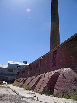
Brunswick brickworks
Australian mechanical brickworks
Distance: Approx. 1562 meters
Latitude and longitude: -37.769985,144.952412
The Brunswick Brick Tile & Pottery Company was established in 1870 on a 12-acre paddock on Albert Street Brunswick, as one of the first modern mechanical brickworks in Australia. It was also known as the Hoffman Patent Brick & Tile Company, Hoffman Brickworks, or just ' Hoffman's' for most of its 100 plus years of operation. The Hoffman brickworks was founded by Jenkin Collier and James McKenzie with Messrs Barry Owen and Rourke.

Brunswick Baptist Church
Church in Victoria, Australia
Distance: Approx. 1744 meters
Latitude and longitude: -37.765534,144.96231
The Brunswick Baptist Church is a Baptist church in 491 Sydney Road, Brunswick, Melbourne, Victoria, Australia. The church is affiliated with the Australian Baptist Ministries.
Weather in this IP's area
clear sky
11 Celsius
10 Celsius
9 Celsius
13 Celsius
1019 hPa
69 %
1019 hPa
1014 hPa
10000 meters
4.12 m/s
10 degree
06:42:06
19:32:03