Country:
 Australia
Region:
City:
Latitude and Longitude:
Time Zone:
Postal Code:
IP information under different IP Channel
ip-api
Country
Region
City
ASN
Time Zone
ISP
Blacklist
Proxy
Latitude
Longitude
Postal
Route
IPinfo
Country
Region
City
ASN
Time Zone
ISP
Blacklist
Proxy
Latitude
Longitude
Postal
Route
MaxMind
Country
Region
City
ASN
Time Zone
ISP
Blacklist
Proxy
Latitude
Longitude
Postal
Route
Luminati
Country
AURegion
vic
City
melbourne
ASN
Time Zone
Australia/Melbourne
ISP
TPG Telecom Limited
Latitude
Longitude
Postal
db-ip
Country
Region
City
ASN
Time Zone
ISP
Blacklist
Proxy
Latitude
Longitude
Postal
Route
ipdata
Country
Region
City
ASN
Time Zone
ISP
Blacklist
Proxy
Latitude
Longitude
Postal
Route
Popular places and events near this IP address
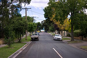
Kew East, Victoria
Suburb of Melbourne, Victoria, Australia
Distance: Approx. 997 meters
Latitude and longitude: -37.79694444,145.05694444
Kew East is a suburb of Melbourne, Victoria, Australia, 8 km east from the Melbourne central business district, located within the City of Boroondara local government area. Kew East recorded a population of 6,620 at the 2021 census.
Ivanhoe Grammar School
School in Ivanhoe & Mernda, Victoria, Australia
Distance: Approx. 1694 meters
Latitude and longitude: -37.775,145.04416667
Ivanhoe Grammar School is a private, co-educational, Anglican, day school, located in Ivanhoe (Buckley House and The Ridgeway Campus) and Doreen (Plenty Campus), both located in the north-eastern suburbs of Melbourne, Victoria, Australia. Founded in 1915 as St James' Grammar School for boys, Ivanhoe Grammar is a school of the Anglican Church of Australia, and caters for approximately 2,200 students from the Early Learning Centre to Year 12, across four campuses. The school is affiliated with the Headmasters' and Headmistresses' Conference, the Association of Heads of Independent Schools of Australia, the Junior School Heads Association of Australia, and is a founding member of the Associated Grammar Schools of Victoria.

Darebin Creek
River in Victoria, Australia
Distance: Approx. 1161 meters
Latitude and longitude: -37.78416667,145.04
Darebin Creek is a creek that runs through the northern suburbs of Melbourne, Victoria, Australia. It is the main watercourse of the Darebin Valley and a major tributary of the Yarra River. For tens of thousands of years it was used as a food and tool source sustainably by the Wurundjeri people, Indigenous Australians of the Kulin nation alliance, who spoke variations of the Woiwurrung language group.
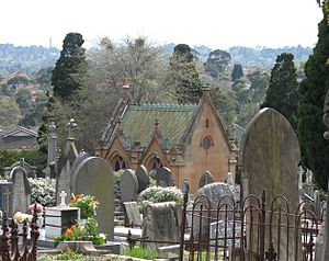
Boroondara General Cemetery
Cemetery in Melbourne, Victoria, Australia
Distance: Approx. 1740 meters
Latitude and longitude: -37.8034,145.044
Boroondara General Cemetery, often referred to as Kew cemetery, is one of the oldest cemeteries in Victoria, Australia, created in the tradition of the Victorian garden cemetery. The cemetery, located in Kew, a suburb of Melbourne, is listed as a heritage place on the Victorian Heritage Register.
Alphington Grammar School
Private school, co-educational school in Alphington, Victoria, Australia
Distance: Approx. 1675 meters
Latitude and longitude: -37.78036111,145.03611111
Alphington Grammar School is a private, co-educational secondary school located in Alphington, Victoria, Australia, established by the Orthodox Community of Melbourne in 1988. The school was designed to reflect the cultural diversity of Melbourne, and is non-denominational with students from around 25 ethnic and religious backgrounds.
Kew High School
School in East Kew, Victoria, Australia
Distance: Approx. 1188 meters
Latitude and longitude: -37.7953,145.0626
Kew High School is a co-educational school in suburban Melbourne for students in years 7–12. The school has an enrolment of approximately 1146 students from the suburbs of Kew, Balwyn North, Hawthorn, Ivanhoe, Kew East and Richmond.
East Kew railway station
Railway station located at Kew, Melbourne, Australia
Distance: Approx. 1374 meters
Latitude and longitude: -37.80111111,145.05472222
East Kew was a railway station on the Outer Circle railway line, located in the suburb of Kew, Melbourne, Victoria, Australia. The station opened with the line on 24 March 1891, and closed with the line on 12 April 1893. It was on the west side of Normanby Road, and was the site of a crossing loop, with a platform on each track.
Willsmere railway station
Former railway station in Victoria, Australia
Distance: Approx. 1487 meters
Latitude and longitude: -37.79489,145.036525
Willsmere was a railway station on the Outer Circle railway line, located in the suburb of Kew, Melbourne, Australia. The station was named after the estate of early Kew settlers H.S. and Thomas Wills. Willsmere was opened with the line in 1891 and closed with it in 1893.
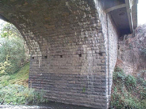
Darebin Creek Bridge
Bridge in Melbourne, Australia
Distance: Approx. 1810 meters
Latitude and longitude: -37.778879,145.035594
Darebin Creek Bridge is a bluestone masonry arch and concrete road bridge on Heidelberg road Alphington over Darebin Creek. It was built for Heidelberg Road Trust to a design of John C Climie CE and constructed by contractor O. H. Willison in 1864, to replace an earlier 1852 timber bridge which had fallen into a poor state of repair. The bridge was made possible as a result of funds obtained from a toll gate, established on the east side of the Darebin Creek by the Heidelberg Road Trust.
St. John's Greek Orthodox College
School in Preston, Victoria, Australia
Distance: Approx. 1675 meters
Latitude and longitude: -37.78036111,145.03611111
St John’s College is an independent co-educational P–12 school, founded on the Greek Orthodox tradition. Initially established in North Carlton in 1979, the college moved to its current location in Preston in 1984. The college was founded to provide education of Greek culture and religion to Melbourne’s large Greek community.
Glass Creek
Waterway in Melbourne, Australia
Distance: Approx. 766 meters
Latitude and longitude: -37.79166667,145.05972222
Glass Creek is a waterway flowing through the middle ring eastern suburbs of Melbourne. It is a minor tributary of the Yarra River and now largely runs through a series of underground drains.
2020 Eastern Freeway truck crash
Traffic accident in Victoria, Australia
Distance: Approx. 234 meters
Latitude and longitude: -37.78883,145.054348
On 22 April 2020, a truck driver under the influence of drugs, Mohinder Singh, crashed his truck into a Porsche 911 and two police cars on the Eastern Freeway, in the city of Kew East, Australia, killing four police officers who were on routine highway patrol. Prior to the incident, the officers had pulled over the Porsche driver, Richard Pusey, for speeding. After the truck hit the officers, Pusey filmed them for several minutes with vulgar commentary as they lay dying, before fleeing.
Weather in this IP's area
clear sky
11 Celsius
10 Celsius
9 Celsius
13 Celsius
1019 hPa
65 %
1019 hPa
1017 hPa
10000 meters
2.63 m/s
7.19 m/s
14 degree
06:41:39
19:31:40