Country:
 Australia
Region:
City:
Latitude and Longitude:
Time Zone:
Postal Code:
IP information under different IP Channel
ip-api
Country
Region
City
ASN
Time Zone
ISP
Blacklist
Proxy
Latitude
Longitude
Postal
Route
IPinfo
Country
Region
City
ASN
Time Zone
ISP
Blacklist
Proxy
Latitude
Longitude
Postal
Route
MaxMind
Country
Region
City
ASN
Time Zone
ISP
Blacklist
Proxy
Latitude
Longitude
Postal
Route
Luminati
Country
AURegion
sa
City
adelaide
ASN
Time Zone
Australia/Adelaide
ISP
TPG Telecom Limited
Latitude
Longitude
Postal
db-ip
Country
Region
City
ASN
Time Zone
ISP
Blacklist
Proxy
Latitude
Longitude
Postal
Route
ipdata
Country
Region
City
ASN
Time Zone
ISP
Blacklist
Proxy
Latitude
Longitude
Postal
Route
Popular places and events near this IP address
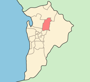
City of Tea Tree Gully
Local government area in South Australia
Distance: Approx. 1655 meters
Latitude and longitude: -34.83333333,138.68333333
The City of Tea Tree Gully is a local council in the Australian state of South Australia, in the outer north-eastern suburbs of Adelaide. The major business district in the city is at Modbury, where Westfield Tea Tree Plaza, Modbury Hospital, the Civic Centre and the library are located. Howard, Lord Florey, Australian pathologist and co-discoverer of penicillin, was a resident of the City of Tea Tree Gully.

Para Hills, South Australia
Suburb of Adelaide, South Australia
Distance: Approx. 1140 meters
Latitude and longitude: -34.81666667,138.66666667
Para Hills is a residential suburb of Adelaide, South Australia. There is a light aircraft airport close to its boundary, and numerous sporting facilities, abundant parks and schools and two medium-sized shopping centres. Most of the suburb is in the City of Salisbury while some is in the City of Tea Tree Gully.

Electoral district of Florey
South Australian state electoral district
Distance: Approx. 1152 meters
Latitude and longitude: -34.82861111,138.67944444
Florey is a single-member electoral district for the South Australian House of Assembly. It is named after scientist Howard Florey, who was responsible for the development of penicillin. It is a 21.25 km2 (8.20 sq mi) suburban electorate in Adelaide's north-east, taking in the suburbs of Ingle Farm, Modbury North, Para Vista, Pooraka, Valley View, and Walkley Heights, as well as parts of Modbury and Northfield.

Ingle Farm, South Australia
Suburb of City of Salisbury, South Australia
Distance: Approx. 1968 meters
Latitude and longitude: -34.823,138.646
Ingle Farm is an established, residential suburb, with some parklands, of about 8,500 people in the South Australian capital city of Adelaide. It is located at the base of the Mount Lofty Ranges foothills, around 12 kilometres north-east of Adelaide's central business district. It covers an area of 4.47 km2 with a population density of 19.41 people per hectare in 2001.

Modbury, South Australia
Suburb of Adelaide, South Australia
Distance: Approx. 1655 meters
Latitude and longitude: -34.83333333,138.68333333
Modbury is a suburb of Adelaide, South Australia in the City of Tea Tree Gully. Modbury is located at the end of the Adelaide O-Bahn and is home to the Tea Tree Plaza shopping complex and Modbury Hospital. It was named Modbury by R. S. Kelly, on 1 September 1840, after his native town in Devonshire.
Valley View, South Australia
Suburb of Adelaide, South Australia
Distance: Approx. 1612 meters
Latitude and longitude: -34.841,138.663
Valley View is a suburb of Adelaide, South Australia. It spans three separate local government areas. They are the City of Salisbury, the City of Port Adelaide Enfield, and the City of Tea Tree Gully.

Modbury North, South Australia
Suburb of Adelaide, South Australia
Distance: Approx. 512 meters
Latitude and longitude: -34.829,138.672
Modbury North is a suburb 14 km northeast of Adelaide, capital city of South Australia. Modbury North is a suburb in the City of Tea Tree Gully Council area. The suburb is bounded by Milne Road in the north, Golden Grove Road in the east and Montague Road in the south.
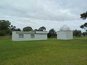
The Heights Observatory
Observatory
Distance: Approx. 2135 meters
Latitude and longitude: -34.812439,138.682356
The Heights Observatory is an Astronomical Observatory at The Heights School in Modbury Heights, Adelaide, South Australia. It is sometimes known as the Adelaide Observatory, but it is not to be confused with the observatory formerly established at the University of Adelaide.
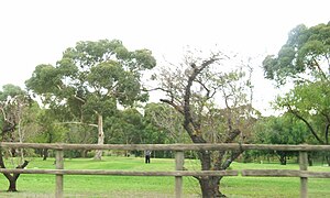
Para Vista, South Australia
Suburb of Adelaide, South Australia
Distance: Approx. 186 meters
Latitude and longitude: -34.82666667,138.665
Para Vista is a suburb in northern Adelaide, South Australia. It is bounded by Wright Road to the South. The northern boundary of the suburb is Montague, Nelson and Milne Roads, making an backwards-L shape of the suburb.
Electoral district of Yatala
Former South Australian state electoral district
Distance: Approx. 1655 meters
Latitude and longitude: -34.83333333,138.68333333
Yatala is a former electorate of the South Australian House of Assembly located within the cadastral Hundred of Yatala. It was one of the original Assembly districts in 1857, abolished in 1902. Yatala was also the name of an electoral district of the unicameral South Australian Legislative Council from 1851 until its abolition in 1857, William Giles, then Arthur Blyth being the members.

Hundred of Yatala
Cadastral in South Australia
Distance: Approx. 1000 meters
Latitude and longitude: -34.82,138.66
The Hundred of Yatala is a cadastral unit of hundred in South Australia covering much of the Adelaide metropolitan area north of the River Torrens. It is one of the eleven hundreds of the County of Adelaide stretching from the Torrens in the south to the Little Para River in the north; and spanning from the coast in the west to the Adelaide foothills in the east. It is roughly bisected from east to west by Dry Creek.
Hundred of Caltowie
Cadastral in South Australia
Distance: Approx. 1000 meters
Latitude and longitude: -34.82,138.66
The Hundred of Caltowie is a cadastral unit of hundred in South Australia centred on the township of Caltowie. It is one of the 14 hundreds of the County of Victoria and was proclaimed by Governor James Fergusson in July 1871.
Weather in this IP's area
clear sky
18 Celsius
17 Celsius
18 Celsius
20 Celsius
1016 hPa
25 %
1016 hPa
1001 hPa
10000 meters
4.63 m/s
40 degree
06:40:49
19:24:07