Country:
 Australia
Region:
City:
Latitude and Longitude:
Time Zone:
Postal Code:
IP information under different IP Channel
ip-api
Country
Region
City
ASN
Time Zone
ISP
Blacklist
Proxy
Latitude
Longitude
Postal
Route
IPinfo
Country
Region
City
ASN
Time Zone
ISP
Blacklist
Proxy
Latitude
Longitude
Postal
Route
MaxMind
Country
Region
City
ASN
Time Zone
ISP
Blacklist
Proxy
Latitude
Longitude
Postal
Route
Luminati
Country
AURegion
tas
City
sulphurcreek
ASN
Time Zone
Australia/Hobart
ISP
TPG Telecom Limited
Latitude
Longitude
Postal
db-ip
Country
Region
City
ASN
Time Zone
ISP
Blacklist
Proxy
Latitude
Longitude
Postal
Route
ipdata
Country
Region
City
ASN
Time Zone
ISP
Blacklist
Proxy
Latitude
Longitude
Postal
Route
Popular places and events near this IP address
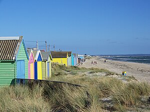
Aspendale, Victoria
Suburb of Melbourne, Victoria, Australia
Distance: Approx. 347 meters
Latitude and longitude: -38.025,145.104
Aspendale is a suburb in Melbourne, Victoria, Australia, 27 km south-east of Melbourne's Central Business District, located within the City of Kingston local government area. Aspendale recorded a population of 7,285 at the 2021 census.
Braeside, Victoria
Suburb of Melbourne, Victoria, Australia
Distance: Approx. 3218 meters
Latitude and longitude: -38,145.125
Braeside is a suburb in Melbourne, Victoria, Australia, 25 km south-east of Melbourne's Central Business District, located within the City of Kingston local government area. Braeside recorded a population of 25 at the 2021 census. Braeside is a largely industrial suburb with little residential areas.

Edithvale, Victoria
Suburb of Melbourne, Victoria, Australia
Distance: Approx. 1898 meters
Latitude and longitude: -38.037,145.113
Edithvale is a beachside suburb in Melbourne, Victoria, Australia, 28 km south-east of Melbourne's Central Business District, located within the City of Kingston local government area. Edithvale recorded a population of 6,276 at the 2021 census.

Mordialloc, Victoria
Suburb of Melbourne, Victoria, Australia
Distance: Approx. 2604 meters
Latitude and longitude: -37.99944444,145.09611111
Mordialloc ( MOR-dee-AL-ək) is a beachside suburb in Melbourne, Victoria, Australia, 24 km south-east of Melbourne's Central Business District, located within the City of Kingston local government area. Mordialloc recorded a population of 8,886 at the 2021 census.
Mordialloc railway station
Railway station in Victoria, Australia
Distance: Approx. 2161 meters
Latitude and longitude: -38.0066,145.0875
Mordialloc railway station is a commuter railway station on the Frankston line, which is part of the Melbourne railway network. It serves the south-eastern suburb of Mordialloc, in Melbourne, Victoria, Australia. Mordialloc station is a ground level unstaffed station, featuring two side platforms.

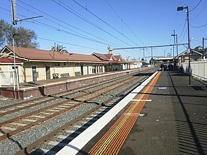
Aspendale railway station
Railway station in Melbourne, Australia
Distance: Approx. 546 meters
Latitude and longitude: -38.0273,145.102
Aspendale railway station is a commuter railway station on the Frankston line, which is part of the Melbourne railway network. It serves the south-eastern suburb of Aspendale, in Melbourne, Victoria, Australia. Aspendale station is a ground-level unstaffed station, featuring two side platforms.

Edithvale railway station
Railway station in Melbourne, Australia
Distance: Approx. 1833 meters
Latitude and longitude: -38.038,145.1085
Edithvale railway station is a commuter railway station on the Frankston line, which is part of the Melbourne railway network. It serves the south-eastern suburb of Edithvale, in Melbourne, Victoria, Australia. Edithvale station is a ground level premium station, featuring two side platforms.

Aspendale Gardens, Victoria
Suburb of Melbourne, Victoria, Australia
Distance: Approx. 1498 meters
Latitude and longitude: -38.02277778,145.11888889
Aspendale Gardens is a suburb in Melbourne, Victoria, Australia, 27 km south-east of Melbourne's Central Business District, located within the City of Kingston local government area. Aspendale Gardens recorded a population of 6,427 at the 2021 census. Wells Road (State Route 23) transects the suburb.

Waterways, Victoria
Suburb of Melbourne, Victoria, Australia
Distance: Approx. 2573 meters
Latitude and longitude: -38.016,145.13
Waterways is a suburb in Melbourne, Victoria, Australia, 25 km (16 mi) south-east of Melbourne's Central Business District, located within the City of Kingston local government area. Waterways recorded a population of 2,422 at the 2021 census. Originally a housing development, it is surrounded by the much larger suburbs of Braeside, Aspendale Gardens, Keysborough and Bangholme, and the Mornington Peninsula Freeway traverses the western side of the suburb.
Aspendale Racecourse
19th-to-mid-20th century Australian horse and motor racetrack
Distance: Approx. 615 meters
Latitude and longitude: -38.025,145.108
Aspendale Racecourse or Aspendale Park Racecourse, located at Aspendale, Victoria, Australia, was a horse racing venue, and the world's first purpose-built motor racing track. Aspendale Racecourse opened on 14 April 1891. It was established by James Robert Crooke, a horse trainer, who named the course after Aspen, one of his best horses, which had won the Newmarket Handicap twice, in 1880 and 1881.
Mordialloc Secondary College
State co-educational secondary school in Melbourne, Victoria, Australia
Distance: Approx. 1409 meters
Latitude and longitude: -38.0122,145.0923
Mordialloc Secondary College or Mordialloc College is a state co-educational secondary school located in the suburbs of Melbourne at Aspendale, City of Kingston, on the south bank of the Mordialloc Creek.

Mordialloc Aboriginal Reserve
Aboriginal Reserve in Victoria on the coast of Port Phillip Bay c.1850–1860s
Distance: Approx. 2604 meters
Latitude and longitude: -37.99944444,145.09611111
Mordialloc Aboriginal Reserve in Victoria on the coast of Port Phillip Bay was on traditional land of the Bunurong people to which they gradually retreated from surrounding areas after white settlement from the 1850s. Most had moved, or had been relocated, to Coranderk by the mid-1860s.
Weather in this IP's area
clear sky
11 Celsius
11 Celsius
10 Celsius
13 Celsius
1019 hPa
71 %
1019 hPa
1018 hPa
10000 meters
0.45 m/s
0.89 m/s
90 degree
06:41:16
19:31:39