Country:
 Australia
Region:
City:
Latitude and Longitude:
Time Zone:
Postal Code:
IP information under different IP Channel
ip-api
Country
Region
City
ASN
Time Zone
ISP
Blacklist
Proxy
Latitude
Longitude
Postal
Route
IPinfo
Country
Region
City
ASN
Time Zone
ISP
Blacklist
Proxy
Latitude
Longitude
Postal
Route
MaxMind
Country
Region
City
ASN
Time Zone
ISP
Blacklist
Proxy
Latitude
Longitude
Postal
Route
Luminati
Country
AURegion
nsw
City
sydney
ASN
Time Zone
Australia/Sydney
ISP
TPG Telecom Limited
Latitude
Longitude
Postal
db-ip
Country
Region
City
ASN
Time Zone
ISP
Blacklist
Proxy
Latitude
Longitude
Postal
Route
ipdata
Country
Region
City
ASN
Time Zone
ISP
Blacklist
Proxy
Latitude
Longitude
Postal
Route
Popular places and events near this IP address

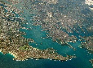
Lindfield, New South Wales
Suburb of Sydney, New South Wales, Australia
Distance: Approx. 1135 meters
Latitude and longitude: -33.77674,151.17119
Lindfield is a suburb on the Upper North Shore of Sydney in the state of New South Wales, Australia. It is 13 kilometres north-west of the Sydney Central Business District and is in the local government area of Ku-ring-gai Council. East Lindfield is a separate suburb to the east, sharing the postcode of 2070.
North Shore (Sydney)
Region in New South Wales, Australia
Distance: Approx. 441 meters
Latitude and longitude: -33.78333333,151.16666667
The North Shore is a region within Northern Sydney, in New South Wales, Australia, generally referring to suburbs located on the northern side of Sydney Harbour up to Wahroonga, and suburbs between Middle Harbour and the Lane Cove River. The term "North Shore", used to describe this region of Sydney is customary, not legal or administrative, and is often subjective.

Lindfield railway station
Railway station in Sydney, New South Wales, Australia
Distance: Approx. 1131 meters
Latitude and longitude: -33.77513,151.169
Lindfield railway station is a heritage-listed railway station located on the North Shore line, serving the Sydney suburb of Lindfield. It is served by Sydney Trains T1 North Shore line services.

Roseville railway station, Sydney
Railway station in Sydney, New South Wales, Australia
Distance: Approx. 1426 meters
Latitude and longitude: -33.78421,151.17728
Roseville railway station is a heritage-listed railway station and garden located on the North Shore line, serving the Sydney suburb of Roseville. It is served by Sydney Trains T1 North Shore line and T9 Northern line services.
Roseville, New South Wales
Suburb of Sydney, New South Wales, Australia
Distance: Approx. 1064 meters
Latitude and longitude: -33.78903,151.17119
Roseville is a suburb on the Upper North Shore of Sydney in the state of New South Wales, Australia 12 kilometres (7.5 mi) north-west of the Sydney central business district, in the local government areas of Ku-ring-gai and Willoughby. Roseville Chase is a separate suburb to the east.
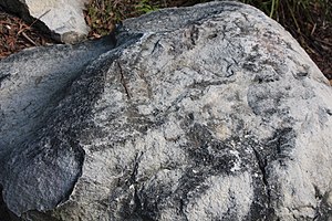
Commandment Rock
Distance: Approx. 1538 meters
Latitude and longitude: -33.7888,151.1466
Commandment Rock is a large rock located in the Lane Cove National Park, Sydney, New South Wales, Australia. The site is home to rock engravings, both Aboriginal and European. An engraving of the Fifth Commandment on the rock gives it its name.

Fullers Bridge
Road bridge in suburban Sydney, Australia
Distance: Approx. 1128 meters
Latitude and longitude: -33.792692,151.157048
Fullers Bridge, officially called the Fullers Creek Bridge, is a road bridge that carries Delhi Road to Millwood Avenue across the Lane Cove River, in Chatswood West, Sydney, New South Wales, Australia. The concrete beam bridge is located 9 kilometres (5.6 mi) northwest of the Sydney central business district and connects Chatswood to North Ryde as part of the A38. The main entrance to Lane Cove National Park is located adjacent to the western end of Fullers Bridge.
RAAF Bradfield Park
Australian air station
Distance: Approx. 1344 meters
Latitude and longitude: -33.77803333,151.14888611
RAAF Bradfield Park was a Royal Australian Air Force (RAAF) station located at the former suburb of Bradfield Park (now Lindfield), New South Wales during World War II.

North Shore Synagogue
Australian Modern Orthodox Jewish synagogue
Distance: Approx. 1408 meters
Latitude and longitude: -33.771061,151.165267
The North Shore Synagogue is a Modern Orthodox Jewish synagogue located in the Sydney suburb of Lindfield, New South Wales, Australia. Founded in 1947, and having built its synagogue in 1950, it is the oldest synagogue on Sydney's North Shore.

Woodlands, Killara
Historic site in New South Wales, Australia
Distance: Approx. 1576 meters
Latitude and longitude: -33.7696,151.1657
Woodlands is a heritage-listed residence at 1 Werona Avenue, in the Sydney suburb of Killara in the Ku-ring-gai Council local government area of New South Wales, Australia. It was designed by Henry Austin Wilshire, and built from 1884. It is also known as Inglewood; Inglenook.

Tryon Road Uniting Church
Church in New South Wales, Australia
Distance: Approx. 1414 meters
Latitude and longitude: -33.7745,151.1728
Tryon Road Uniting Church is a heritage-listed Uniting church located at 33 Tryon Road in the Sydney suburb of Lindfield in the Ku-ring-gai Council local government area of New South Wales, Australia. It was designed by William Slade and built in 1914 by W. 'Ossie' Knowles. It is also known as Lindfield Wesleyan Methodist Church.
Bradfield, New South Wales (1924–1977)
Suburb of Sydney, New South Wales, Australia
Distance: Approx. 1528 meters
Latitude and longitude: -33.7755,151.1484
Bradfield, the western portion of which was also known as Bradfield Park, was a suburb on the North Shore of Sydney, Australia between 1924 and 1977, since absorbed by neighbouring Lindfield. The name commemorates Dr John Job Crew Bradfield, who oversaw design and construction of the Sydney Harbour Bridge between 1913 and 1932.
Weather in this IP's area
light rain
13 Celsius
13 Celsius
12 Celsius
14 Celsius
1024 hPa
82 %
1024 hPa
1016 hPa
10000 meters
1.34 m/s
1.79 m/s
345 degree
97 %
06:20:18
19:04:08