Country:
 USA
USARegion:
City:
Latitude and Longitude:
Time Zone:
Postal Code:
IP information under different IP Channel
ip-api
Country
Region
City
ASN
Time Zone
ISP
Blacklist
Proxy
Latitude
Longitude
Postal
Route
IPinfo
Country
Region
City
ASN
Time Zone
ISP
Blacklist
Proxy
Latitude
Longitude
Postal
Route
MaxMind
Country
Region
City
ASN
Time Zone
ISP
Blacklist
Proxy
Latitude
Longitude
Postal
Route
Luminati
Country
USASN
Time Zone
America/Chicago
ISP
DNIC-AS-00749
Latitude
Longitude
Postal
db-ip
Country
Region
City
ASN
Time Zone
ISP
Blacklist
Proxy
Latitude
Longitude
Postal
Route
ipdata
Country
Region
City
ASN
Time Zone
ISP
Blacklist
Proxy
Latitude
Longitude
Postal
Route
Popular places and events near this IP address

Whitehall, Ohio
City in Ohio, United States
Distance: Approx. 1728 meters
Latitude and longitude: 39.96722222,-82.87694444
Whitehall is a city in the U.S state of Ohio, located 6.6 miles (10.6 km) east of the state capital of Columbus in Franklin County. Whitehall had a population of 20,127 in the 2020 census. Founded in 1947, Whitehall is a growing suburb of Columbus.
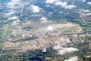
John Glenn Columbus International Airport
Airport serving Columbus, Ohio, United States
Distance: Approx. 2611 meters
Latitude and longitude: 39.99805556,-82.89194444
John Glenn Columbus International Airport (IATA: CMH, ICAO: KCMH, FAA LID: CMH) is an international airport located 6 miles (9.7 km; 5.2 nmi) east of downtown Columbus, Ohio. Formerly known as Port Columbus International Airport, it is managed by the Columbus Regional Airport Authority, which also oversees operations at Rickenbacker International Airport and Bolton Field. The airport code "CMH" stands for "Columbus Municipal Hangar," the original name of the airport.

Defense Supply Center, Columbus
Distance: Approx. 28 meters
Latitude and longitude: 39.9746,-82.8944
The Defense Electronics Supply Center, Columbus (DSCC), is one of three Inventory Control Points of the Defense Logistics Agency. The major organization on base is known as DLA Land and Maritime. Defense Finance and Accounting Service (DFAS) is also a major tenant on base.

Columbus Africentric Early College
Public high school in Columbus, Ohio, United States
Distance: Approx. 1897 meters
Latitude and longitude: 39.97930556,-82.91611111
Columbus Africentric Early College is a public high school in Columbus, Ohio. It is a part of Columbus City Schools. The school's previous name, Mohawk Middle School, was changed in the late 1990s, to allow the school not only separation from its original status, but also to expand it into a large school.
Eastmoor Academy
Public, coeducational high school in Columbus, , Ohio, United States
Distance: Approx. 1696 meters
Latitude and longitude: 39.96361111,-82.90833333
Eastmoor Academy is a public high school located on the east side of Columbus, Ohio. It is part of Columbus City Schools. Eastmoor Academy was formerly known as Eastmoor High School.

Whitehall-Yearling High School
Public high school in Whitehall, Ohio, , United States
Distance: Approx. 1728 meters
Latitude and longitude: 39.96027778,-82.88722222
Whitehall-Yearling High School is a public high school located in Whitehall, Ohio, United States.
1964 PGA Championship
Golf tournament
Distance: Approx. 2286 meters
Latitude and longitude: 39.973,-82.868
The 1964 PGA Championship was the 46th PGA Championship, played July 16–19 at Columbus Country Club in Columbus, Ohio. Bobby Nichols won his only major title, three strokes ahead of runners-up Jack Nicklaus and Arnold Palmer. Nichols led wire-to-wire after a first round 64 in the hometown of Nicklaus, who shot a 64 in the final round to gain his third runner-up finish in majors in 1964.

Columbus Country Club
Country club in Columbus, Ohio, US
Distance: Approx. 2300 meters
Latitude and longitude: 39.97361111,-82.86777778
Columbus Country Club is a country club located in Columbus, Ohio. The club was established in 1903. The golf course at the club hosted the PGA Championship in 1964, which Bobby Nichols won.

Norton Field
Airport in Columbus, Ohio
Distance: Approx. 1359 meters
Latitude and longitude: 39.97,-82.88
Norton Field was an aviation landing field, located in Columbus, Ohio, that operated from 1923 until the early 1950s. It was the first airport established in Central Ohio, and was named for World War I pilot and star Ohio State University athlete Fred William Norton, a Columbus native. Lieutenant Norton, of the 27th Pursuit Squadron, died of injuries suffered when his Nieuport 28 was shot down in northern France by anti-aircraft artillery in July 1918.

Old Port Columbus Terminal
United States historic place
Distance: Approx. 2377 meters
Latitude and longitude: 39.986854,-82.87179
The Old Port Columbus Terminal, also known as the Old Port Columbus Airport Control Tower, is a historic building in Columbus, Ohio. It was built in 1929 as one of the first airport facilities in the United States. It was replaced by the current facilities in 1958.

Kahiki Supper Club
Former restaurant in Columbus, Ohio
Distance: Approx. 889 meters
Latitude and longitude: 39.9725,-82.904722
The Kahiki Supper Club was a Polynesian-themed restaurant in Columbus, Ohio. The supper club was one of the largest tiki-themed restaurants in the United States, and for a time, the only one in Ohio. It operated at its Eastmoor location on Broad Street beginning in 1961, at the height of tiki culture's popularity.
Ohio History of Flight Museum
Aviation museum in Columbus, Ohio
Distance: Approx. 2823 meters
Latitude and longitude: 40,-82.8924
The Ohio History of Flight Museum was an aviation museum located at the Port Columbus International Airport in Columbus, Ohio.
Weather in this IP's area
clear sky
4 Celsius
3 Celsius
2 Celsius
5 Celsius
1029 hPa
82 %
1029 hPa
1000 hPa
10000 meters
1.54 m/s
10 degree
07:45:31
18:47:24