109.94.214.138 - IP Lookup: Free IP Address Lookup, Postal Code Lookup, IP Location Lookup, IP ASN, Public IP
Country:
 Germany
Region:
City:
Location:
Time Zone:
Postal Code:
ISP:
ASN:
language:
User-Agent:
Proxy IP:
Blacklist:
IP information under different IP Channel
ip-api
Country
Region
City
ASN
Time Zone
ISP
Blacklist
Proxy
Latitude
Longitude
Postal
Route
db-ip
Country
Region
City
ASN
Time Zone
ISP
Blacklist
Proxy
Latitude
Longitude
Postal
Route
IPinfo
Country
Region
City
ASN
Time Zone
ISP
Blacklist
Proxy
Latitude
Longitude
Postal
Route
IP2Location
109.94.214.138Country
deRegion
schleswig-holstein
City
schenefeld
Time Zone
Europe/Berlin
ISP
Language
User-Agent
Latitude
Longitude
Postal
ipdata
Country
Region
City
ASN
Time Zone
ISP
Blacklist
Proxy
Latitude
Longitude
Postal
Route
Popular places and events near this IP address

H1 (particle detector)
Distance: Approx. 2516 meters
Latitude and longitude: 53.59016,9.884361
H1 was a particle detector operated at the HERA (Hadron Elektron Ring Anlage) collider at the German national laboratory DESY in Hamburg. The first studies for the H1 experiment were proposed in 1981. The H1 detector began operating together with HERA in 1992 and took data until 2007.
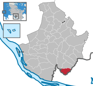
Schenefeld, Pinneberg
Town in Schleswig-Holstein, Germany
Distance: Approx. 1790 meters
Latitude and longitude: 53.60277778,9.82333333
Schenefeld (Northern Low Saxon: Scheenfeld) is a town in the district of Pinneberg, in Schleswig-Holstein, Germany. It is situated at the northwest border of Hamburg. A 3.4 km tunnel between the town and the DESY research centre in Hamburg houses the European X-ray free-electron laser, with the research campus for the facility also located in Schenefeld.

European XFEL
Distance: Approx. 1843 meters
Latitude and longitude: 53.589,9.829
The European X-Ray Free-Electron Laser Facility (European XFEL) is an X-ray research laser facility commissioned during 2017. The first laser pulses were produced in May 2017 and the facility started user operation in September 2017. The international project with twelve participating countries; nine shareholders at the time of commissioning (Denmark, France, Germany, Hungary, Poland, Russia, Slovakia, Sweden and Switzerland), later joined by three other partners (Italy, Spain and the United Kingdom), is located in the German federal states of Hamburg and Schleswig-Holstein.

Lurup
Quarter of Hamburg in Germany
Distance: Approx. 2296 meters
Latitude and longitude: 53.59305556,9.88277778
Lurup () is a quarter in the Altona borough of the Free and Hanseatic city of Hamburg in northern Germany. It was formerly an independent village. In 2020 the population was 36,521.
Elbgaustraße station
Railway station in Germany
Distance: Approx. 2895 meters
Latitude and longitude: 53.6025,9.89361111
Elbgaustraße railway station is on the Hamburg-Altona–Kiel line and is served by the city trains located in Hamburg, Germany. The railway station is located in the quarter of Eidelstedt in the Eimsbüttel borough. After on 16 July 1922 the Eidelstedt marshalling yard (Verschiebebahnhof) had opened and, after the Reichsbahn had established railwaymen in company housings in the environs, a first station for suburban traffic was opened.

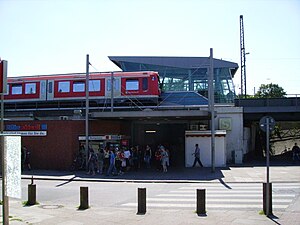
Krupunder station
S Bahn Station in Schleswig-Holstein
Distance: Approx. 2097 meters
Latitude and longitude: 53.61527778,9.86833333
Krupunder station is on the Hamburg-Altona–Kiel line and is a railway station served by the city trains of the Hamburg S-Bahn. The railway station is located in the municipality Halstenbek in the district of Pinneberg, in Schleswig-Holstein, Germany, directly at the border to Hamburg.

Japanische Schule in Hamburg
Primary & middle school in Halstenbek, Germany
Distance: Approx. 3107 meters
Latitude and longitude: 53.6259,9.8329
The Japanische Schule in Hamburg e.V. (ハンブルグ日本人学校, Hanburugu Nihonjin Gakkō) is a Japanese international school located in Halstenbek, Schleswig-Holstein, Germany, within the Hamburg Metropolitan Region.

Altona Main Cemetery
Cemetery in Hamburg, Germany
Distance: Approx. 2949 meters
Latitude and longitude: 53.586,9.888
Altona Main Cemetery (German: Hauptfriedhof or Friedhof Altona) is located at Stadiongasse 5, Bahrenfeld, Altona, in north-western Hamburg, Germany and, with an area of 63 hectares, is the fourth largest burial ground in the city and surrounding area. It has been a protected site since the revision of the Hamburg Monument Protection Law (Hamburger Denkmalschutzgesetz) in 2013.

Osdorfer Born
Distance: Approx. 1348 meters
Latitude and longitude: 53.5878,9.8506
Osdorfer Born is a major estate of prefabricated houses in the Osdorf and Lurup quarters of Hamburg, Germany. It is named after a small stream flowing into the Düpenau stream.

Luruper Moorgraben
River in Germany
Distance: Approx. 700 meters
Latitude and longitude: 53.59444444,9.84472222
Luruper Moorgraben (Lurup Bog Ditch) is a small stream in Osdorf, Hamburg, Germany, partially marking the boundaries of Lurup, Hamburg, after which it is named. It comes to the surface near the street of Knüllkamp in Osdorf. Nearby, from the right, the small stream of Müllergraben flows into Luruper Moorgraben.

Born Park
Distance: Approx. 735 meters
Latitude and longitude: 53.594,9.845
Born Park (German: Bornpark) is public park in Osdorf, Hamburg, Germany. Located around Lake Helmuth Schack and the streams of Düpenau and Luruper Moorgraben, it is used as a recreational area mainly by the inhabitants of Osdorf, Osdorfer Born and nearby Schenefeld in Schleswig-Holstein. The park extends to an area of 13.4 hectares (33 acres).

Lise-Meitner-Gymnasium
Distance: Approx. 2940 meters
Latitude and longitude: 53.5737,9.8556
The Lise-Meitner-Gymnasium (LMG) is a high school in Osdorf, Hamburg. It bore the name Gymnasium Osdorf until 1 January 2007, when it officially adopted the name of the Austrian-Swedish nuclear physicist Lise Meitner.
Weather in this IP's area
clear sky
-0 Celsius
-6 Celsius
-0 Celsius
-0 Celsius
1021 hPa
64 %
1021 hPa
1019 hPa
7000 meters
6.17 m/s
70 degree