Country:
 Ireland
Region:
City:
Latitude and Longitude:
Time Zone:
Postal Code:
IP information under different IP Channel
ip-api
Country
Region
City
ASN
Time Zone
ISP
Blacklist
Proxy
Latitude
Longitude
Postal
Route
IPinfo
Country
Region
City
ASN
Time Zone
ISP
Blacklist
Proxy
Latitude
Longitude
Postal
Route
MaxMind
Country
Region
City
ASN
Time Zone
ISP
Blacklist
Proxy
Latitude
Longitude
Postal
Route
Luminati
Country
IERegion
l
City
dublin
ASN
Time Zone
Europe/Dublin
ISP
Vodafone Ireland Limited
Latitude
Longitude
Postal
db-ip
Country
Region
City
ASN
Time Zone
ISP
Blacklist
Proxy
Latitude
Longitude
Postal
Route
ipdata
Country
Region
City
ASN
Time Zone
ISP
Blacklist
Proxy
Latitude
Longitude
Postal
Route
Popular places and events near this IP address
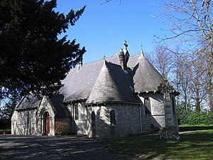
Carrickmines Castle
Former castle in Ireland
Distance: Approx. 1176 meters
Latitude and longitude: 53.253292,-6.175398
Carrickmines Castle is an archaeological site in Carrickmines, County Dublin, in eastern Ireland. The castle was built in the Middle Ages to protect the English-ruled Pale around Dublin. The mostly subsurface ruins lay in the path of the M50 motorway, completed in 2005.
Kilternan
Village in Dún Laoghaire–Rathdown, near Dublin, Ireland
Distance: Approx. 1334 meters
Latitude and longitude: 53.2356,-6.1934
Kilternan (Irish: Cill Tiarnáin, meaning 'Church of Tiarnán'), also known as Kiltiernan, is a village in Dún Laoghaire–Rathdown, in the foothills of the Wicklow Mountains south of Dublin, Ireland, near the border with County Wicklow.
Rathmichael
Remote southern suburb of Dublin, Ireland
Distance: Approx. 1649 meters
Latitude and longitude: 53.23583333,-6.15555556
Rathmichael (Irish: Ráth Mhichíl) is a suburb south-east of Dublin, in the local government area of Dún Laoghaire–Rathdown, near the southern border of the traditional County Dublin. It is situated west of Shankill from which it is, roughly, separated by the M50/M11 motorways. It is also a civil parish in the barony of Rathdown.
Carrickmines
Outer suburb of Dublin, Ireland
Distance: Approx. 627 meters
Latitude and longitude: 53.248,-6.181
Carrickmines (Irish: Carraig Mhaighin, meaning 'Plateau of rock') is an outer suburb of Dublin in Dún Laoghaire–Rathdown, Ireland. The area, still semi-rural, was historically on the border of English control and featured a defensive construction, Carrickmines Castle, which became the subject of national controversy during the building of a late stage of Dublin's M50 orbital motorway.
Jackson Park, Kilternan
Football stadium
Distance: Approx. 656 meters
Latitude and longitude: 53.240863,-6.186697
Jackson Park (Irish: Páirc Uí Sheáin) is an association football stadium in the Republic of Ireland based in Kilternan, Dún Laoghaire–Rathdown.

Carrickmines fire
2015 multi-fatality fire near Dublin, Ireland
Distance: Approx. 848 meters
Latitude and longitude: 53.2423,-6.1901
On Saturday, 10 October 2015, a blaze swept through a halting site at Carrickmines in County Dublin, Ireland. It proved fatal. This was the country's deadliest such disaster since the Stardust fire.

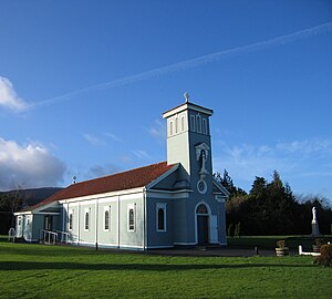
Tully Church
Church in Ireland, Ireland
Distance: Approx. 1735 meters
Latitude and longitude: 53.246818,-6.152242
Tully Church is an ancient church in County Dublin, Ireland.

Laughanstown Luas stop
Tram stop in Dublin, Ireland
Distance: Approx. 1726 meters
Latitude and longitude: 53.25061238,-6.15501545
Laughanstown (Irish: Baile an Locháin) is a stop on the green line of the Luas light-rail tram system in Dún Laoghaire–Rathdown, County Dublin, Ireland. The stop provides access to the nearby suburb of Cabinteely.

Ballyogan Wood Luas stop
Tram stop in Dublin, Ireland
Distance: Approx. 1445 meters
Latitude and longitude: 53.25505943,-6.18454783
Ballyogan Wood (Irish: Coill Bhaile Ógain) is a stop on the green line of the Luas light-rail tram system in Dún Laoghaire–Rathdown, County Dublin, Ireland. The stop provides access to the nearby residential area of Ballyogan, as well as providing access to the nearby Carrickmines Park.

Carrickmines Luas stop
Rail stop in County Dublin, Ireland
Distance: Approx. 1342 meters
Latitude and longitude: 53.25401,-6.16997
Carrickmines (Irish: Carraig Mhaighin) is a stop on the Luas light rail tram system in Dún Laoghaire–Rathdown, County Dublin, Ireland, which serves the nearby village of Carrickmines. It opened in 2010 and was built on the site of a disused heavy rail station of the same name.

Dingle Glen, Dublin
Wooded glen in Dún Laoghaire–Rathdown, Ireland
Distance: Approx. 433 meters
Latitude and longitude: 53.23916667,-6.17972222
Dingle Glen (Irish: An Fhothair) is a steep-sided and V-shaped valley "gash", or glen, extending for 550-metres through the bedrock of the lowlands of the Dublin Mountains, located between Carrickmines and Kilternan. In an ecological impact assessment for a proposed development nearby, Dingle Glen was categorised as "a secluded mature broadleaf woodland, mixed with rocky outcrops, within a glacier meltwater channel, thus providing a diversity of habitats within a small undisturbed area".

Shanganagh River
River in County Dublin, Ireland
Distance: Approx. 358 meters
Latitude and longitude: 53.246,-6.178
The Shanganagh River is the largest watercourse system in Dún Laoghaire–Rathdown (in southern County Dublin). It has two main source lines, one from Three Rock Mountain, one with multiple sources between Three Rock and Foxrock, and its components pass through many suburbs of Dublin; it ultimately reaches the sea on Killiney Strand, in Shanganagh. The river is in the jurisdiction of Dún Laoghaire–Rathdown County Council, as well as within the purview of the Environmental Protection Agency.
Weather in this IP's area
scattered clouds
15 Celsius
15 Celsius
15 Celsius
17 Celsius
1007 hPa
93 %
1007 hPa
993 hPa
10000 meters
1.79 m/s
4.47 m/s
246 degree
43 %
06:47:05
19:57:51