Country:
 Ireland
Region:
City:
Latitude and Longitude:
Time Zone:
Postal Code:
IP information under different IP Channel
ip-api
Country
Region
City
ASN
Time Zone
ISP
Blacklist
Proxy
Latitude
Longitude
Postal
Route
IPinfo
Country
Region
City
ASN
Time Zone
ISP
Blacklist
Proxy
Latitude
Longitude
Postal
Route
MaxMind
Country
Region
City
ASN
Time Zone
ISP
Blacklist
Proxy
Latitude
Longitude
Postal
Route
Luminati
Country
IERegion
l
City
dublin
ASN
Time Zone
Europe/Dublin
ISP
Vodafone Ireland Limited
Latitude
Longitude
Postal
db-ip
Country
Region
City
ASN
Time Zone
ISP
Blacklist
Proxy
Latitude
Longitude
Postal
Route
ipdata
Country
Region
City
ASN
Time Zone
ISP
Blacklist
Proxy
Latitude
Longitude
Postal
Route
Popular places and events near this IP address

Clonsilla
Western suburb of Dublin, Ireland
Distance: Approx. 443 meters
Latitude and longitude: 53.38333333,-6.41666667
Clonsilla (Irish: Cluain Saileach, meaning 'meadow of the willow or sally tree') is an outer suburb of Dublin in Fingal, Ireland. Clonsilla is also a civil parish in the barony of Castleknock in the traditional County Dublin.

Coolmine
Suburb of Dublin, Ireland
Distance: Approx. 1374 meters
Latitude and longitude: 53.3844,-6.3944
Coolmine (Irish: Cúil Mhín, meaning 'smooth corner') is a primarily residential suburb of Dublin, Ireland, in the jurisdiction of Fingal. It is also a townland in the civil parish of Clonsilla.

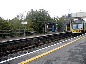
Clonsilla railway station
Station in suburbs of Dublin, Ireland
Distance: Approx. 719 meters
Latitude and longitude: 53.383,-6.423
Clonsilla railway station is a railway station that serves Clonsilla, in Fingal, Ireland.
Coolmine railway station
Railway station in County Dublin, Ireland
Distance: Approx. 1496 meters
Latitude and longitude: 53.3775,-6.3914
Coolmine railway station serves Coolmine, County Dublin, Ireland. It lies on the Dublin to Maynooth and Dublin Docklands to M3 Parkway railway station commuter routes. A large car park is located next to the station, making it a popular park and ride location.

Castleknock Community College
Community college of the school in Castleknock, Fingal, Ireland
Distance: Approx. 1791 meters
Latitude and longitude: 53.3718,-6.3902
Castleknock Community College, is an Irish secondary school located on Carpenterstown Road in Castleknock, Fingal in Ireland. Established in 1995, the school is overseen by the Dublin and Dún Laoghaire Education and Training Board.

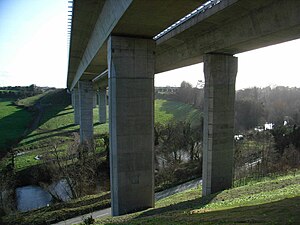
Luttrellstown Castle
15th-century castle, now a hotel, Dublin, Ireland
Distance: Approx. 263 meters
Latitude and longitude: 53.37926667,-6.41745556
Luttrellstown Castle is a castellated house located in Clonsilla on the outskirts of Dublin, Ireland dating from the early 15th century (c. 1420). It has been owned variously by the eponymous and notorious Luttrell family, by the bookseller Luke White and his descendants Baron Annaly, by the Guinness family, the Primwest Group, and since 2006, by JP McManus, John Magnier and Aidan Brooks.

Coolmine Community School
Secondary school in Dublin, Ireland
Distance: Approx. 1552 meters
Latitude and longitude: 53.3887,-6.3956
Coolmine Community School (Irish: Scoil Pobail Chúil Mhín) is a co-educational secondary school in the Coolmine suburb of Dublin. It lies within Greater Blanchardstown in the administration of Fingal.

Castleknock GAA
Gaelic Athletic Association club in Ireland
Distance: Approx. 758 meters
Latitude and longitude: 53.37359722,-6.40888333
Castleknock Hurling and Football Club is a Dublin GAA club centered on the townlands of Carpenterstown and Diswellstown in the civil parish of Castleknock in Fingal, Ireland. It serves large parts of the suburban areas of Castleknock, Hartstown, Coolmine, Blanchardstown, Laurel Lodge and Clonsilla. The club plays the following Gaelic games at all age levels from nursery to adult: Hurling, Gaelic football, Camogie and Ladies' Gaelic football.
St Peregrine's GAA
Distance: Approx. 1754 meters
Latitude and longitude: 53.39465833,-6.40480556
St Peregrine's GAA, also known as Cumann Naomh Peregrine C.L.G., is a Gaelic Athletic Association club in Clonsilla, Fingal, Ireland.

Hartstown Community School
Secondary school in Republic of Ireland
Distance: Approx. 1821 meters
Latitude and longitude: 53.3961,-6.41594
Hartstown Community School is an Irish Secondary School located in Hartstown, Clonsilla. It serves the area of Hartstown, Huntstown and other localities in the Clonsilla suburb. Hartstown / Huntstown Community School is a co-educational, multi-denominational Community School founded in 1992 to cater for the educational needs of Hartstown & Huntstown 2nd level pupils.
St. Mochta's F.C.
Irish soccer (association football) club
Distance: Approx. 607 meters
Latitude and longitude: 53.378,-6.40497222
St. Mochta's F.C. is an Irish association football club based in Clonsilla, Dublin. Their senior team play in the Leinster Senior League Senior Division.
Strawberry Beds
Locality west of Dublin, Ireland
Distance: Approx. 1511 meters
Latitude and longitude: 53.3676,-6.40362
Strawberry Beds or The Strawberry Beds (Irish: Na Ceapóga Sú Talún) is a locality and small settlement 7 km to the west of Dublin City, Ireland, located on the northern banks of the River Liffey between Chapelizod and Lucan where the closest bridges span the river. The populated suburb of Palmerstown lies just south of the Strawberry Beds, but is inaccessible due to the Liffey which separates them. The R109 road, also known as the 'Lower Road' for the section between Chapelizod and Lucan, is the only road that passes through the Strawberry Beds.
Weather in this IP's area
scattered clouds
15 Celsius
15 Celsius
14 Celsius
17 Celsius
1008 hPa
95 %
1008 hPa
1001 hPa
7000 meters
4.63 m/s
290 degree
40 %
06:47:51
19:58:58