109.75.253.83 - IP Lookup: Free IP Address Lookup, Postal Code Lookup, IP Location Lookup, IP ASN, Public IP
Country:
 Russian Federation
Region:
City:
Location:
Time Zone:
Postal Code:
ISP:
ASN:
language:
User-Agent:
Proxy IP:
Blacklist:
IP information under different IP Channel
ip-api
Country
Region
City
ASN
Time Zone
ISP
Blacklist
Proxy
Latitude
Longitude
Postal
Route
db-ip
Country
Region
City
ASN
Time Zone
ISP
Blacklist
Proxy
Latitude
Longitude
Postal
Route
IPinfo
Country
Region
City
ASN
Time Zone
ISP
Blacklist
Proxy
Latitude
Longitude
Postal
Route
IP2Location
109.75.253.83Country
ruRegion
pskovskaya oblast'
City
pskov
Time Zone
Europe/Moscow
ISP
Language
User-Agent
Latitude
Longitude
Postal
ipdata
Country
Region
City
ASN
Time Zone
ISP
Blacklist
Proxy
Latitude
Longitude
Postal
Route
Popular places and events near this IP address

Pskov
City in Pskov Oblast, Russia
Distance: Approx. 1012 meters
Latitude and longitude: 57.81666667,28.33333333
Pskov (Russian: Псков, IPA: [psˈkof] ; see also names in other languages) is a city in northwestern Russia and the administrative center of Pskov Oblast, located about 20 kilometers (12 mi) east of the Estonian border, on the Velikaya River. Population: 193,082 (2021 Census); 203,279 (2010 Census); 202,780 (2002 Census); 203,789 (1989 Soviet census). Pskov is one of the oldest cities in Russia.

Siege of Pskov
Siege in Pskov, Russia during the Livonian War
Distance: Approx. 1012 meters
Latitude and longitude: 57.81666667,28.33333333
The siege of Pskov, known as the Pskov Defense in Russia (Russian: оборона Пскова), took place between August 1581 and February 1582, when the army of the Polish king and Grand Duke of Lithuania Stephen Báthory laid an unsuccessful siege and successful blockade of the city of Pskov during the final stage of the Livonian War of 1558–1583. The first detachments of the Polish–Lithuanian army, which in the previous two years captured Polotsk (1579) and Velikiye Luki (1580), appeared at the walls of Pskov on August 18, 1581. This action completely cut off Russian forces from the territory of Livonia.
Trinity Cathedral, Pskov
Distance: Approx. 1543 meters
Latitude and longitude: 57.82194444,28.32861111
The Trinity Cathedral (Russian: Троицкий собор) is located in the Pskov Krom or Kremlin on the east bank of the Velikaya (Great) River. It has, since 1589, been the mother church of the Pskov Eparchy. The first wooden Trinity Cathedral (the Russian term sobor, translated as "cathedral" can mean any major church irrespective of it being a cathedral church of a bishop) was built in the tenth century, allegedly under the patronage of Princess Olga, but this seems unlikely as Olga's conversion was personal, and the conversion of the Rus Land did not occur until 988, almost two decades after her death.

Mirozhsky Monastery
Distance: Approx. 1493 meters
Latitude and longitude: 57.8056,28.3292
Mirozhsky Monastery is a 12th century Russian Orthodox monastery complex in Pskov, Russia, famous for its frescoes, located in the Christ's Transfiguration Cathedral. The name of the monastery is derived from the name of the Mirozha River, since the monastery is located at the place where the Mirozha joins the Velikaya River, on the left bank of the Velikaya. The catholicon of the monastery is one of the two pre-Mongol buildings which survived in Pskov, and contains the frescoes of the 12th century.

Pskov State Polytechnic Institute
Former university of Pskov region
Distance: Approx. 241 meters
Latitude and longitude: 57.81466111,28.35294167
The Pskov State Polytechnic Institute (PPI) was a major educational institution in the Pskov Region. About 7000 full-time and part-time students study at PPI. In 2010 it was merged with the Pskov State Pedagogical Institute to form the Pskov State University.

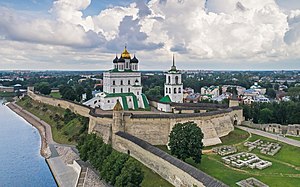
Pskov Krom
Distance: Approx. 1467 meters
Latitude and longitude: 57.82138889,28.32944444
The Pskov Krom (Russian: Псковский Кром, romanized: Pskovsky Krom), also known as the Pskov Kremlin (Russian: Псковский Кремль, romanized: Pskovsky Kreml'), is a citadel in Pskov, Russia. In the central part of the city, the Krom is located at the junction of the Velikaya and Pskova rivers. The citadel is of medieval origin, with the surrounding walls constructed starting in the late 15th century.

Pskova
River in Russia
Distance: Approx. 1884 meters
Latitude and longitude: 57.82527778,28.32638889
The Pskova (Russian: Пскова) is a river in Strugo-Krasnensky and Pskovsky Districts of Pskov Oblast, as well as in the city of Pskov in Russia. It is a right tributary of the Velikaya and belongs to the basin of the Narva. It is 102 kilometres (63 mi) long, and the area of its basin 1,000 square kilometres (390 sq mi).

Pskov Governorate
1772–1927 unit of Russia
Distance: Approx. 1012 meters
Latitude and longitude: 57.81666667,28.33333333
Pskov Governorate (Russian: Псковская губерния, romanized: Pskovskaya guberniya) was an administrative-territorial unit (guberniya) of the Russian Empire and the Russian SFSR, which existed in 1772–1777 and 1796–1927. Its seat was located in Opochka between 1772 and 1776, and in Pskov after 1776. The governorate was located in the west of the Russian Empire and bordered (after 1796) Saint Petersburg Governorate in the north, Novgorod Governorate in the northeast, Tver Governorate in the east, Smolensk Governorate in the southeast, Belarusian Governorate (since 1802, Vitebsk Governorate) in the south, and Governorate of Livonia in the west.

Cheryokha
River in Russia
Distance: Approx. 4923 meters
Latitude and longitude: 57.76972222,28.35972222
The Cheryokha (Russian: Черёха) is a river in Ostrovsky, Porkhovsky, and Pskovsky Districts, and in the city of Pskov of Pskov Oblast in Russia. It is a right tributary of the Velikaya and belongs to the basin of the Narva. It is 145 kilometres (90 mi) long, and the area of its basin 3,230 square kilometres (1,250 sq mi).
Pskov Viceroyalty
1777–1796 unit of Russia
Distance: Approx. 1012 meters
Latitude and longitude: 57.81666667,28.33333333
Pskov Viceroyalty (Russian: Псковское наместничество, romanized: Pskovskoye namestnichestvo) was an administrative-territorial unit (namestnichestvo) of the Russian Empire, which existed in 1777–1796. The seat of the Viceroyalty was located in Pskov. Both the predecessor and the successor of the viceroyalty was Pskov Governorate.

Ivanovsky Monastery, Pskov
Distance: Approx. 2304 meters
Latitude and longitude: 57.82583333,28.31805556
The Convent of Nativity of Saint John the Baptist (Russian: Ивановский монастырь) is a former Russian Orthodox nunnery in Pskov. It is notable for the katholikon, one of Russia's oldest churches, dating from the first half of the 12th century. The church is located at the city center, on the left bank of the Velikaya River, in the Zavelichye quarter.

Riga Bridge (Velikaya River)
Railway bridge in Pskov, Russia
Distance: Approx. 1990 meters
Latitude and longitude: 57.7965,28.3396
The Riga Bridge (Riia sild in Estonian) is a railway bridge that crosses the Velikaya River at Pskov, Russia. It forms part of the branch line from Valga to Tartu of Pskov-Riga Railway.
Weather in this IP's area
light snow
-1 Celsius
-6 Celsius
-1 Celsius
-1 Celsius
1015 hPa
93 %
1015 hPa
1009 hPa
10000 meters
4 m/s
280 degree
100 %