Country:
Region:
City:
Latitude and Longitude:
Time Zone:
Postal Code:
IP information under different IP Channel
ip-api
Country
Region
City
ASN
Time Zone
ISP
Blacklist
Proxy
Latitude
Longitude
Postal
Route
Luminati
Country
ASN
Time Zone
Europe/London
ISP
Iomart Managed Services Limited
Latitude
Longitude
Postal
IPinfo
Country
Region
City
ASN
Time Zone
ISP
Blacklist
Proxy
Latitude
Longitude
Postal
Route
db-ip
Country
Region
City
ASN
Time Zone
ISP
Blacklist
Proxy
Latitude
Longitude
Postal
Route
ipdata
Country
Region
City
ASN
Time Zone
ISP
Blacklist
Proxy
Latitude
Longitude
Postal
Route
Popular places and events near this IP address

Morley, West Yorkshire
Market town and civil parish in West Yorkshire, England
Distance: Approx. 222 meters
Latitude and longitude: 53.749166,-1.602263
Morley is a market town and a civil parish within the City of Leeds metropolitan borough, in West Yorkshire, England. Morley is the largest town in the borough after Leeds itself. Morley forms part of the Heavy Woollen District.
The Morley Academy
Academy in Morley, West Yorkshire, England
Distance: Approx. 649 meters
Latitude and longitude: 53.74252,-1.60757
The Morley Academy is a mixed secondary school located in Morley, West Yorkshire, England. The school forms part of the Gorse Academies Trust which also includes The Farnley Academy, The Ruth Gorse Academy and the Elliott Hudson College.

Morley and Rothwell (UK Parliament constituency)
Parliamentary constituency in the United Kingdom, 1997–2010
Distance: Approx. 201 meters
Latitude and longitude: 53.749,-1.602
Morley and Rothwell was a parliamentary constituency represented in the House of Commons of the Parliament of the United Kingdom. It elected one Member of Parliament (MP) by the first past the post system of election.

Morley railway station
Railway station in West Yorkshire, England
Distance: Approx. 726 meters
Latitude and longitude: 53.7497,-1.5915
Morley railway station serves the town of Morley in West Yorkshire, England. The station is on the Huddersfield Line and is currently operated by Northern. It is located approximately 5 miles (8 km) south-west of Leeds at the northern end of the 3,369-yard (3,081 m) Morley Tunnel which passes beneath the town.

Morley Town Hall
Municipal building in Morley, West Yorkshire, England
Distance: Approx. 145 meters
Latitude and longitude: 53.7459,-1.6019
Morley Town Hall is a municipal facility in Morley, West Yorkshire, England. The town hall, which is the meeting place of Morley Town Council, is a Grade I listed building.
Municipal Borough of Morley
Former local government area of Leeds, West Yorkshire, England
Distance: Approx. 1321 meters
Latitude and longitude: 53.758,-1.61
Morley was a local government district in the West Riding of Yorkshire. Apart from the town of Morley, it included Churwell (a separate Local Government District until 1891), East Ardsley (or Ardsley East), West Ardsley, Drighlington and Gildersome (urban districts absorbed in 1937). Morley was incorporated as a borough in 1885.

Bruntcliffe Academy
Academy in Morley, West Yorkshire, England
Distance: Approx. 1184 meters
Latitude and longitude: 53.74562,-1.61946
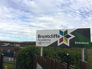
Bruntcliffe Academy (formerly Bruntcliffe School) is a coeducational secondary school located in Morley, West Yorkshire, England. It is situated on Bruntcliffe Lane in Morley, and is one of three secondary schools in the area.

Morley Tunnel
Railway tunnel in West Yorkshire, England
Distance: Approx. 842 meters
Latitude and longitude: 53.7397,-1.6033
Morley Tunnel is a railway tunnel in West Yorkshire, England, situated between Morley and Batley railway stations on the Huddersfield line. From its northern end (53.7490°N 1.5927°W / 53.7490; -1.5927), it extends 3,369 yards (3,081 m), passing beneath Morley town centre, to its southern end (53.7260°N 1.6192°W / 53.7260; -1.6192).

Morley War Memorial, Scatcherd Park
Distance: Approx. 125 meters
Latitude and longitude: 53.74772,-1.60337
The Morley War Memorial is a British national war memorial situated in Scatcherd Park, Morley, Leeds, England. It was sculpted by Walter Henry Gilbert and cast by H.H. Martyn & Co., it was unveiled 21 May 1927 by Alderman Joseph Kirk and accepted by Mayor Alderman Thomas Marshall. The war memorial was added to the National Heritage List for England on 17 June 1986 as a Grade II listed structure.

Morley Top railway station
Disused railway station in Morley, West Yorkshire
Distance: Approx. 702 meters
Latitude and longitude: 53.7409,-1.6011
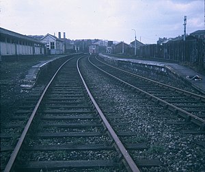
Morley Top railway station served the town of Morley, West Yorkshire, England, from 1857 to 1969 on the Leeds, Bradford and Halifax Junction Railway.

St Mary's in the Wood Church, Morley
Congregational church in Morley, West Yorkshire, England
Distance: Approx. 71 meters
Latitude and longitude: 53.747833,-1.601534
St Mary's in the Wood Church is a redundant and former United Reformed Church place of worship in Morley, West Yorkshire, England. It was built in 1876-78 on the site of a medieval church. The former church is situated on Troy Road and Commercial Street north of the town.

Leeds South West and Morley (UK Parliament constituency)
Parliamentary constituency in the United Kingdom, 2024 onwards
Distance: Approx. 830 meters
Latitude and longitude: 53.75,-1.59
Leeds South West and Morley is a constituency of the House of Commons in the UK Parliament. Further to the completion of the 2023 Periodic Review of Westminster constituencies, it was first contested in the 2024 general election.
Weather in this IP's area
haze
8 Celsius
6 Celsius
7 Celsius
8 Celsius
1026 hPa
89 %
1026 hPa
1008 hPa
4500 meters
2.57 m/s
170 degree
40 %
07:24:15
16:16:35