109.70.239.196 - IP Lookup: Free IP Address Lookup, Postal Code Lookup, IP Location Lookup, IP ASN, Public IP
Country:
 Germany
Region:
City:
Location:
Time Zone:
Postal Code:
ISP:
ASN:
language:
User-Agent:
Proxy IP:
Blacklist:
IP information under different IP Channel
ip-api
Country
Region
City
ASN
Time Zone
ISP
Blacklist
Proxy
Latitude
Longitude
Postal
Route
db-ip
Country
Region
City
ASN
Time Zone
ISP
Blacklist
Proxy
Latitude
Longitude
Postal
Route
IPinfo
Country
Region
City
ASN
Time Zone
ISP
Blacklist
Proxy
Latitude
Longitude
Postal
Route
IP2Location
109.70.239.196Country
deRegion
hessen
City
idstein
Time Zone
Europe/Berlin
ISP
Language
User-Agent
Latitude
Longitude
Postal
ipdata
Country
Region
City
ASN
Time Zone
ISP
Blacklist
Proxy
Latitude
Longitude
Postal
Route
Popular places and events near this IP address
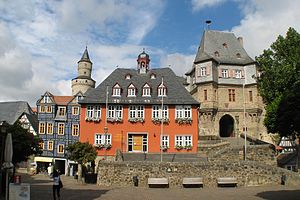
Idstein
Town in Hesse, Germany
Distance: Approx. 460 meters
Latitude and longitude: 50.22138889,8.26972222
Idstein (German: [ˈʔɪtʃtaɪn] ) is a town of about 25,000 inhabitants in the Rheingau-Taunus-Kreis in the Regierungsbezirk of Darmstadt in Hesse, Germany. Because of its well preserved historical Altstadt (Old Town) it is part of the Deutsche Fachwerkstraße (German Timber-Frame Road), connecting towns with fine fachwerk buildings and houses. In 2002, the town hosted the 42nd Hessentag state festival.

St. Martin, Idstein
Church in Idstein, Germany
Distance: Approx. 133 meters
Latitude and longitude: 50.21888889,8.26666667
St. Martin is the name of a Catholic parish and church in Idstein, Rheingau-Taunus-Kreis, Germany. The official name of the church is Katholische Pfarrkirche St.

Unionskirche, Idstein
Protestant church in Idstein, Germany
Distance: Approx. 406 meters
Latitude and longitude: 50.22083333,8.26972222
The Unionskirche (Union Church) is the active Protestant parish church of Idstein, a town in the Rheingau-Taunus district in the German state of Hesse. Idstein was a residence of the counts of Nassau. The church building in the center of the historic Altstadt (old town) dates back to the 14th century when it was built as a collegiate church.

Idstein Castle
Castle in Hesse, Germany
Distance: Approx. 489 meters
Latitude and longitude: 50.2219,8.2688
Idstein Castle (German: Burg Idstein), later the Renaissance style Schloss Idstein, is located in Idstein in the county of Rheingau-Taunus, Germany. The hill castle was the residenz of the counts of Nassau-Idstein. The castle's Witches' Tower (Hexenturm) is one of the town's oldest buildings and a substantial local landmark.
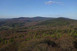
Main ridge of the Taunus
Distance: Approx. 5506 meters
Latitude and longitude: 50.174699,8.304977
The main ridge of the Taunus (German: Taunushauptkamm) is a 75-kilometre-long ridgeline in the High Taunus mountain in Germany, whose geological core consists of veins of hard Taunus quartzite. The ridge separates the steeply descending Anterior Taunus to the south from the more gradually descending upland of the Hintertaunus or Farther Taunus in the north. The watershed between the Upper Rhine and River Main to the south and the Middle Rhine tributaries of the Wisper and Lahn to the north, runs for long sections along the main ridge.

Taunus Nature Park
Distance: Approx. 3886 meters
Latitude and longitude: 50.19,8.3
The Taunus Nature Park (German: Naturpark Taunus) (until December 2012 called the High Taunus Nature Park or Naturpark Hochtaunus) is a nature park in Central Germany with an area of 134,775 hectares (1347.75 km2) in the Central Upland range of the Taunus. It is one of two Hessian nature parks in the Taunus and the second largest nature park in Hesse.

Hintertaunus
Distance: Approx. 2785 meters
Latitude and longitude: 50.209,8.23013889
The Hintertaunus ("Rear Taunus") is a natural region in the German Central Upland range of the Taunus (major unit group 30), which rises to a height of 700.7 m above sea level (NHN) and lies north of the High Taunus (301). It extends as far as the river Rhine to the west, the river Lahn to the north and the Wetterau hills to the east. It is divided into the Eastern Hintertaunus (major unit 302), Idstein Basin (303) and Western Hintertaunus (304).

Kastell Zugmantel
Distance: Approx. 5486 meters
Latitude and longitude: 50.1897,8.20344
Kastell Zugmantel (Latin name unknown) is a former Roman garrison site designed for a complement the size of a cohort. The facility is located on the western Taunus section of the Upper Germanic-Rhaetian Limes, and has been a UNESCO World Heritage Site since 2005. The above-ground remains in the area, still very visible, are located in a forest edge area of Taunusstein-Orlen in the Hessian Rheingau-Taunus-Kreis.

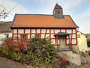
St. Nikolaus von Flüe, Wörsdorf
Catholic church in Wörsdorf, Idstein, Rheingau-Taunus-Kreis, Germany
Distance: Approx. 3417 meters
Latitude and longitude: 50.2464,8.2498
St. Nikolaus von Flüe is the name of a Catholic church in Wörsdorf, part of Idstein, Rheingau-Taunus-Kreis, Germany. The official name of the church is Katholische Pfarrkirche St.
Türmchen
Church in Hesse, Germany
Distance: Approx. 3836 meters
Latitude and longitude: 50.19989,8.2207
The Türmchen (Little tower) in Ehrenbach, an Ortsteil of Idstein, Hesse, Germany, is a fachwerk building from around 1780 that served various purposes. The listed historic monument has been a Protestant chapel from 1982.

Ehrenbach
Ortsteil of Idstein in Hesse, Germany
Distance: Approx. 3771 meters
Latitude and longitude: 50.2,8.22166667
Ehrenbach is a village, first mentioned in 1371, that became in 1971 part of Idstein, Hesse, Germany.

St. Martha, Engenhahn
Distance: Approx. 5169 meters
Latitude and longitude: 50.17290421,8.24771225
St. Martha is a Catholic church in Engenhahn, now an Ortsteil of Niedernhausen, Hesse, Germany. It was built in 1890/91 in the west of the village, designed by Alois Vogt, who taught at the Bauschule in Idstein.
Weather in this IP's area
overcast clouds
3 Celsius
0 Celsius
3 Celsius
4 Celsius
1018 hPa
80 %
1018 hPa
977 hPa
3.55 m/s
6.95 m/s
312 degree
100 %