Country:
 Netherlands
Region:
City:
Latitude and Longitude:
Time Zone:
Postal Code:
IP information under different IP Channel
ip-api
Country
Region
City
ASN
Time Zone
ISP
Blacklist
Proxy
Latitude
Longitude
Postal
Route
IPinfo
Country
Region
City
ASN
Time Zone
ISP
Blacklist
Proxy
Latitude
Longitude
Postal
Route
MaxMind
Country
Region
City
ASN
Time Zone
ISP
Blacklist
Proxy
Latitude
Longitude
Postal
Route
Luminati
Country
NLASN
Time Zone
Europe/Amsterdam
ISP
LeaseWeb Netherlands B.V.
Latitude
Longitude
Postal
db-ip
Country
Region
City
ASN
Time Zone
ISP
Blacklist
Proxy
Latitude
Longitude
Postal
Route
ipdata
Country
Region
City
ASN
Time Zone
ISP
Blacklist
Proxy
Latitude
Longitude
Postal
Route
Popular places and events near this IP address
Biomedical Primate Research Centre
Distance: Approx. 1029 meters
Latitude and longitude: 52.0288,4.3404
The Biomedical Primate Research Centre (BPRC) is Europe's largest primate animal testing research centre. It is a scientific research institute that performs research that contributes to the identification and development of new medicines against deadly diseases. It is located in Rijswijk (South Holland) and employs about 110 people.
Menschen Vereeniging Wolbodo
Dutch student organization
Distance: Approx. 1430 meters
Latitude and longitude: 52.014824,4.35751
The Mensenvereniging Wolbodo was founded in 1959 as the PSK (Parochiele Studenten Kring) by 17 students, who were Catholic, but did not want to join the Catholic student society Virgiel. In 1960 the name was changed to Sanctus Wolbodo or in Dutch "Sint Wolbodo", referring both to the saint who supposedly is the patron saint of students and to its Catholic nature.
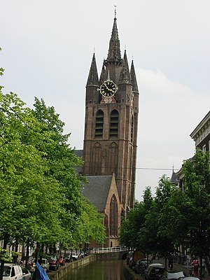
Oude Kerk (Delft)
Distance: Approx. 1681 meters
Latitude and longitude: 52.0125,4.35527778
The Oude Kerk (Old Church), nicknamed Oude Jan ("Old John") and Scheve Jan ("Skewed John"), is a Gothic Protestant church in the old city center of Delft, the Netherlands. Its most recognizable feature is a 75-meter-high brick tower that leans about two meters from the vertical.

Vrijenban
Neighborhood of Delft and Former Municipality in South Holland, Netherlands
Distance: Approx. 1188 meters
Latitude and longitude: 52.01805556,4.36305556
Vrijenban is a neighborhood of Delft in the Netherlands province of South Holland. It is located on the northeast boundary of the historic city center of Delft. Prior to being merged into Delft, Vrijenban used to be a municipality in its own right.
Ypenburg Airport
Distance: Approx. 1496 meters
Latitude and longitude: 52.041,4.357
Ypenburg Airport (Dutch: Vliegveld Ypenburg), which later became Ypenburg Air Base was an airport in the Netherlands in Leidschenveen-Ypenburg near the city of The Hague.

Agnetapark
Area of workers' housing in South Holland
Distance: Approx. 1434 meters
Latitude and longitude: 52.01611111,4.34583333
Agnetapark was an area of workers' housing in Delft, South Holland, the Netherlands. It was one of the highest quality workers' housing areas built before the Housing Act of 1902 was imposed. It was 'transformed' from a marshy 4 hectares (9.9 acres) area of land to a 'paradise' of industry.
't Ganzenest
Restaurant in Rijswijk, Netherlands
Distance: Approx. 1241 meters
Latitude and longitude: 52.03707778,4.34575278
't Ganzenest is a restaurant in Rijswijk, Netherlands. It is a fine dining restaurant that was awarded one Michelin star in 1994 and retained that rating until 2002 and regained it in 2022. The owner and head chef of 't Ganzenest was Harry Visbeen.
Niven (restaurant)
Restaurant in zuid Holland, Netherlands
Distance: Approx. 1241 meters
Latitude and longitude: 52.03707778,4.34575278
Niven is a restaurant in Rijswijk, Netherlands. It is a fine dining restaurant that is awarded one Michelin star in the period 2011–present. GaultMillau awarded the restaurant 14 out of 20 points in 2012, two points less than in 2011.
DSV Concordia
Dutch sports club
Distance: Approx. 1211 meters
Latitude and longitude: 52.0306,4.3723
DSV Concordia is a multi sport club in Delft that has been operating since 1885 and introduced Jan Thomée to the world when he became the leading football goal scorer for the Netherlands and played in the 1908 Summer Olympics as part of the Dutch team that took the Football Bronze.

De Delftse Pauw
Dutch pottery factory
Distance: Approx. 658 meters
Latitude and longitude: 52.0239,4.3478
De Delftse Pauw was a pottery factory from the 17th century located in the north of the city Delft (in the Netherlands) on the Delftweg (close to the Schie). It was one of the few pottery factories which carry on the tradition of handpainted Delft pottery. It was taken over by Heinen Delft Blauw on 1 July 2018, but was declared bankrupt in September 2020.

Lutherse Kerk (Delft)
Church in Netherlands
Distance: Approx. 1342 meters
Latitude and longitude: 52.0156,4.3534
The Lutherse Kerk, also known as St. George's Chapel, is an 18th-century church in the Dutch city of Delft. The church's foundation was laid in the 15th or 16th centuries, with a wooden structure being built on top of it.

De Roos
Mill from Delft, South Holland, Netherlands.
Distance: Approx. 1550 meters
Latitude and longitude: 52.01388889,4.35138889
De Roos (literally, "The Rose"), also locally known as Roosmolen or Koren op de Molen, is a wind and platform mill situated within the municipality of Delft, in the South Holland province of the Netherlands. The mill was originally constructed on the southern city wall of Delft but was later relocated and rebuilt above the western fortifications of the Dutch municipality in 1679. Two principal phases of implementation of the Delft mill followed this reconstruction.
Weather in this IP's area
overcast clouds
15 Celsius
15 Celsius
14 Celsius
15 Celsius
1018 hPa
89 %
1018 hPa
1018 hPa
10000 meters
7.72 m/s
220 degree
87 %
08:18:10
18:35:49