Country:
 Israel
Region:
City:
Latitude and Longitude:
Time Zone:
Postal Code:
IP information under different IP Channel
ip-api
Country
Region
City
ASN
Time Zone
ISP
Blacklist
Proxy
Latitude
Longitude
Postal
Route
IPinfo
Country
Region
City
ASN
Time Zone
ISP
Blacklist
Proxy
Latitude
Longitude
Postal
Route
MaxMind
Country
Region
City
ASN
Time Zone
ISP
Blacklist
Proxy
Latitude
Longitude
Postal
Route
Luminati
Country
ILRegion
m
City
rishonletsiyyon
ASN
Time Zone
Asia/Jerusalem
ISP
Bezeq International Ltd.
Latitude
Longitude
Postal
db-ip
Country
Region
City
ASN
Time Zone
ISP
Blacklist
Proxy
Latitude
Longitude
Postal
Route
ipdata
Country
Region
City
ASN
Time Zone
ISP
Blacklist
Proxy
Latitude
Longitude
Postal
Route
Popular places and events near this IP address
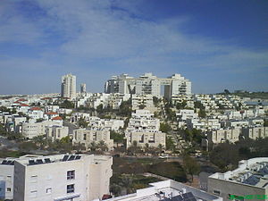
Modi'in-Maccabim-Re'ut
City in Israel
Distance: Approx. 1493 meters
Latitude and longitude: 31.90765278,35.00761389
Modi'in-Maccabim-Re'ut (Hebrew: מוֹדִיעִין-מַכַּבִּים-רֵעוּת Mōdīʿīn-Makkabbīm-Rēʿūt) is a city located in central Israel, about 35 kilometres (22 mi) southeast of Tel Aviv and 30 kilometres (19 mi) west of Jerusalem, and is connected to those two cities via Highway 443. In 2022 the population was 99,171. The population density in that year was 1,794 people per square kilometer.

Route 443 (Israel–Palestine)
Road in Israel
Distance: Approx. 2077 meters
Latitude and longitude: 31.89833333,35.03805556
Route 443 (Hebrew: כביש 443, מעלה בית חורון) is also known as Ma'ale Beit Horon (Bethoron Ascent), following the ancient east-west trade route connecting the Via Maris and the Way of the Patriarchs. It is the main highway connecting Tel Aviv and Gush Dan with Jerusalem via Modi'in. While technically listed as a regional road, it is, for the most part, a divided, four-lane highway which utilizes some grade separation and interchanges, as well as major at-grade intersections, and thus is not classified as a motorway, even though there is a short motorway section on its western end, connecting it to westbound Highway 1.
Bareket Observatory
Observatory
Distance: Approx. 1726 meters
Latitude and longitude: 31.888189,35.031694
The Bareket Observatory (IAU code B35 ; 35.0317°N Parallax sinφ 0.84991 cosφ +0.52524) is an astronomical educational observatory owned and operated by the Bareket family. It is located east of the city of Maccabim, near Modiin.

Modi'in Central railway station
Rail station in Modi'in, Israel
Distance: Approx. 1097 meters
Latitude and longitude: 31.90083333,35.00583333
Modi'in Central railway station (Hebrew: תחנת הרכבת מודיעין מרכז, Tahanat HaRakevet Modi'in Merkaz) is an Israel Railways passenger terminal and one of two stations serving Modi'in (the other being Paatei Modi'in). It is the terminus of the Nahariya-Modi'in line, with service to the airport, Tel Aviv, Haifa, and Akko. It became operational on April 1, 2008.

Kfar Ruth
Israeli moshav in the former no-man's land between Israel and the West Bank
Distance: Approx. 2374 meters
Latitude and longitude: 31.91,35.03555556
Kfar Ruth (Hebrew: כְּפַר רוּת, lit. 'Ruth's Village') is an Israeli settlement organised as a moshav. It was established in 1977 in an area that had become a no-man's land between Israel and Jordanian-controlled West Bank at the end of the 1948 Arab–Israeli War, before becoming part of the Israeli-occupied territories in the 1967 Six-Day War. It falls under the jurisdiction of Hevel Modi'in Regional Council and had a population of 275 in 2022.

Shilat
Moshav in Israel and the Latrun salient
Distance: Approx. 2668 meters
Latitude and longitude: 31.92027778,35.01861111
Shilat (Hebrew: שִׁילָּת) is a moshav partially in Israel and partially in the Latrun salient of the Green Line. Located around a kilometre north of Modi'in, it falls under the jurisdiction of Hevel Modi'in Regional Council. In 2022 it had a population of 770.
Bir Ma'in
Place in Ramle, Mandatory Palestine
Distance: Approx. 996 meters
Latitude and longitude: 31.88805556,35.02
Bir Ma'in (Arabic: بير اماعين/ماعين) was a Palestinian Arab village in the Ramle Subdistrict. It was depopulated during the 1948 Arab-Israeli War on July 15, 1948 during the second phase of Operation Danny by the First and Second Battalions of the Yiftach Brigade. It was located 14 km east of Ramla.

Al-Burj, Ramle
Place in Ramle, Mandatory Palestine
Distance: Approx. 742 meters
Latitude and longitude: 31.90194444,35.02055556
Al-Burj (Arabic: البرج) was a Palestinian Arab village 14 km east of Ramle close to the highway to Ramallah, which was depopulated in 1948. Its name, "the tower", is believed to be derived from the crusader castle, Castle Arnold, built on the site. Victorian visitors in the 19th century recorded seeing crusader ruins close to the village.

Khirbat al-Buwayra
Village in Ramle, Mandatory Palestine
Distance: Approx. 2481 meters
Latitude and longitude: 31.87416667,35.01444444
Khirbat al-Buwayra was a Palestinian Arab village in the Ramle Subdistrict. It was depopulated during the 1948 Arab-Israeli War on July 15, 1948, under the second phase of Operation Dani. It was located 15 km southeast of Ramla.

Shilta
Village in Ramle, Mandatory Palestine
Distance: Approx. 2415 meters
Latitude and longitude: 31.91777778,35.02055556
Shilta was a Palestinian Arab village in the Ramle Subdistrict of Mandatory Palestine. Sitting on a hill, It was probably settled in the 19th century. It was depopulated during the 1948 Arab–Israeli War on July 18, 1948, by the First Battalion of the Yiftach Brigade in the Operation Danny.
Meir Harel Hesder Yeshiva
Distance: Approx. 2524 meters
Latitude and longitude: 31.91417,34.99961
The Meir Harel Hesder Yeshiva, led by Rabbi Eliezer Chaim Shenvald, is a Hesder Yeshiva that works on the Shesder (Hebrew:שסדר) six-year program.

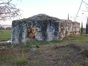
Umm el-Umdan
Jewish archeological site in Israel
Distance: Approx. 2313 meters
Latitude and longitude: 31.88388889,34.99666667
Umm el-Umdan (Arabic for 'Mother of Pillars') or Khirbet Umm el-Umdan (khirbet = ruins of) is a Jewish archaeological site within the municipal boundaries of the Israeli city of Modi'in, between the city of Modi'in and Latrun. Archaeological excavations at the site discovered the remains of a Jewish village. The findings show that the place was inhabited during the Persian, Hellenistic, Roman, Byzantine, and Early Muslim periods.
Weather in this IP's area
clear sky
24 Celsius
24 Celsius
23 Celsius
25 Celsius
1012 hPa
69 %
1012 hPa
983 hPa
10000 meters
2.06 m/s
140 degree
06:27:02
18:39:40