Country:
 Israel
Region:
City:
Latitude and Longitude:
Time Zone:
Postal Code:
IP information under different IP Channel
ip-api
Country
Region
City
ASN
Time Zone
ISP
Blacklist
Proxy
Latitude
Longitude
Postal
Route
IPinfo
Country
Region
City
ASN
Time Zone
ISP
Blacklist
Proxy
Latitude
Longitude
Postal
Route
MaxMind
Country
Region
City
ASN
Time Zone
ISP
Blacklist
Proxy
Latitude
Longitude
Postal
Route
Luminati
Country
ILRegion
ta
City
ramatgan
ASN
Time Zone
Asia/Jerusalem
ISP
Bezeq International Ltd.
Latitude
Longitude
Postal
db-ip
Country
Region
City
ASN
Time Zone
ISP
Blacklist
Proxy
Latitude
Longitude
Postal
Route
ipdata
Country
Region
City
ASN
Time Zone
ISP
Blacklist
Proxy
Latitude
Longitude
Postal
Route
Popular places and events near this IP address

Ramat Gan
City in Israel
Distance: Approx. 695 meters
Latitude and longitude: 32.07,34.82361111
Ramat Gan (Hebrew: רָמַת גַּן or רָמַת־גַּן, IPA: [ʁaˈmat ˈɡan] ) is a city in the Tel Aviv District of Israel, located east of the municipality of Tel Aviv, and part of the Tel Aviv metropolitan area. It is home to a Diamond Exchange District (one of the world's major diamond exchanges), Sheba Medical Center (the largest hospital in Israel) and many high-tech industries. Ramat Gan was established in 1921 as a moshava, a communal farming settlement.
Bnei Brak
City in Israel
Distance: Approx. 1319 meters
Latitude and longitude: 32.08333333,34.83333333
Bnei Brak or Bene Beraq (Hebrew: בְּנֵי בְּרַק ) is a city located on the central Mediterranean coastal plain in Israel, just east of Tel Aviv. A center of Haredi Judaism, Bnei Brak covers an area of 709 hectares (1,752 acres, or 2.74 square miles), and had a population of 218,357 in 2022. It is one of the poorest and most densely populated cities in Israel, and the fourth-most densely populated city in the world.

Bar-Ilan University
Public research university in Ramat Gan, Israel
Distance: Approx. 1196 meters
Latitude and longitude: 32.06777778,34.8425
Bar-Ilan University (BIU, Hebrew: אוניברסיטת בר-אילן, Universitat Bar-Ilan) is a public research university in the Tel Aviv District city of Ramat Gan, Israel. Established in 1955, Bar Ilan is Israel's second-largest academic institution. It has 20,000 students and 1,350 faculty members.

Ponevezh Yeshiva
Religious school in Israel
Distance: Approx. 1295 meters
Latitude and longitude: 32.08319167,34.83280278
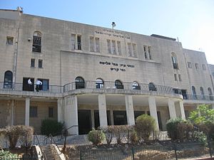
Ponevezh Yeshiva (Lithuanian: Panevėžio ješiva), often pronounced as Ponevitch Yeshiva (Hebrew: ישיבת פוניבז׳), is a yeshiva founded in 1908 in Panevėžys (Ponevezh), Lithuania, and located today in Bnei Brak, Israel since 1944. The yeshiva has over three thousand students, including those of affiliated institutions, and is considered one of the leading Litvish yeshivas in Israel.

Giv'at Shmuel
City in Israel
Distance: Approx. 1735 meters
Latitude and longitude: 32.07805556,34.8475
Giv'at Shmuel (Hebrew: גִּבְעַת שְׁמוּאֵל, lit. 'Samuel's Hill') is a city in the Center District of Israel. It is located in the eastern part of the Gush Dan Metropolitan Area and bordered by Ramat Gan and Bnei Brak to the West, Kiryat Ono to the South and Petah Tikva to the East and North. In 2022 it had a population of 28,994.
Begin–Sadat Center for Strategic Studies
Israeli think tank
Distance: Approx. 1196 meters
Latitude and longitude: 32.06777778,34.8425
The Begin–Sadat Center for Strategic Studies (BESA Center) is an Israeli think tank affiliated with Bar-Ilan University and supported by the NATO Mediterranean Initiative, conducting policy-relevant research on Middle Eastern and global strategic affairs, particularly as they relate to the national security and foreign policy of Israel and regional peace and stability. The center's mission is to contribute to promoting peace and security in the Middle East, through policy-oriented researches on national security in the Middle East. It is located at the Social Sciences Faculty of Bar-Ilan University.

Wohl Centre
Distance: Approx. 1509 meters
Latitude and longitude: 32.07148079,34.84669176
The Wohl Centre is a convention center on the main campus of Bar-Ilan University in Ramat-Gan, Israel.

Beit Zvi
Drama school in Tel Aviv District, Israel
Distance: Approx. 1130 meters
Latitude and longitude: 32.07840833,34.82171389
Beit Zvi School for the Performing Arts, and Theater (Hebrew: בית צבי) is an acting school, and a theater located in the Tel Aviv District city of Ramat Gan, Israel, established in 1950.

Kfar Azar
Neighborhood of Ramat Gan in Ramat Gan, Israel
Distance: Approx. 934 meters
Latitude and longitude: 32.065,34.83666667
Kfar Azar (Hebrew: כְּפַר אֲזָ"ר) is a moshav ovdim located in the Ono Valley in central Israel. Previously part of Ef'al Regional Council, in 2007 it was transferred to the municipality of Ramat Gan together with Ramat Ef'al. With an area of around 1,000 acres (4.0 km2), its population is around 500.
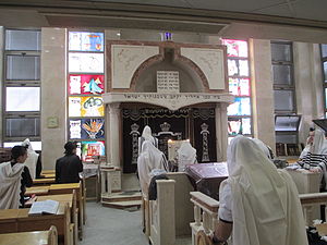
Itzkovitch Synagogue
Shtiebel in Bnei Brak, Israel
Distance: Approx. 1639 meters
Latitude and longitude: 32.08583333,34.83555556
Itzkovitch Synagogue (Hebrew: איצקוביץ') is a shtiebel in central Bnei Brak.

HaAliya HaShniya Garden
Urban park in Tel Aviv, Israel
Distance: Approx. 1516 meters
Latitude and longitude: 32.0697,34.8148
HaAliya HaShniya garden (Hebrew: גן העלייה השנייה) is an urban park in Israel, located on the Kozlovsky Hill in Givatayim. Its summit overlooks the Tel Aviv Metropolitan Area. The park, which is named after the Second Aliyah, is administered by Givatayim Municipality and is one of the oldest gardens in Israel.
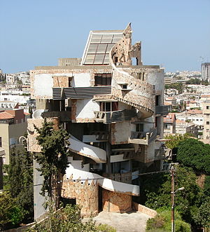
Spiral House
Apartments in Ramat Gan, Israel
Distance: Approx. 1168 meters
Latitude and longitude: 32.07833333,34.82111111
The Spiral House (Hebrew: בית הספירלה, Beit HaSpirala) is an apartment complex in Ramat Gan, Israel, designed by the architect Zvi Hecker. The complex has a form of an upward spiral; it was built by Jaakov Hai and designed by the architect Zvi Hecker in collaboration with Gil Bernstein, Shmuel Groberman, and Rina Hering. The owner is Ezra Mualem.
Weather in this IP's area
clear sky
25 Celsius
26 Celsius
24 Celsius
26 Celsius
1012 hPa
74 %
1012 hPa
1005 hPa
10000 meters
2.06 m/s
140 degree
06:27:45
18:40:26