Country:
 Switzerland
Region:
City:
Latitude and Longitude:
Time Zone:
Postal Code:
IP information under different IP Channel
ip-api
Country
Region
City
ASN
Time Zone
ISP
Blacklist
Proxy
Latitude
Longitude
Postal
Route
IPinfo
Country
Region
City
ASN
Time Zone
ISP
Blacklist
Proxy
Latitude
Longitude
Postal
Route
MaxMind
Country
Region
City
ASN
Time Zone
ISP
Blacklist
Proxy
Latitude
Longitude
Postal
Route
Luminati
Country
CHASN
Time Zone
Europe/Zurich
ISP
Securebit AG
Latitude
Longitude
Postal
db-ip
Country
Region
City
ASN
Time Zone
ISP
Blacklist
Proxy
Latitude
Longitude
Postal
Route
ipdata
Country
Region
City
ASN
Time Zone
ISP
Blacklist
Proxy
Latitude
Longitude
Postal
Route
Popular places and events near this IP address
Menzingen
Municipality in Zug, Switzerland
Distance: Approx. 2777 meters
Latitude and longitude: 47.18333333,8.6
Menzingen is a municipality in the canton of Zug in Switzerland.
Horgen District
District in Switzerland
Distance: Approx. 3865 meters
Latitude and longitude: 47.23333333,8.6
Horgen District is a district of Canton of Zürich in Switzerland. The district is located in the Zimmerberg and Sihl Valley region on the left shore of Lake Zürich; its district capital is Horgen. The district consists of 11 municipalities and has a population of 127,263 (as of 31 December 2020) and an area of 104.16 km2 (40.22 sq mi).
Baar, Switzerland
Municipality in Zug, Switzerland
Distance: Approx. 4535 meters
Latitude and longitude: 47.2,8.51666667
Baar (German pronunciation: [baːr]) is a municipality in the canton of Zug in Switzerland.

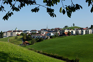
Neuheim
Municipality in Zug, Switzerland
Distance: Approx. 586 meters
Latitude and longitude: 47.2,8.58333333
Neuheim is a municipality in the canton of Zug in Switzerland.

Hirzel
Former municipality in Zurich, Switzerland
Distance: Approx. 2375 meters
Latitude and longitude: 47.21666667,8.6
Hirzel is a former municipality in the district of Horgen in the canton of Zürich in Switzerland. On 1 January 2018 the former municipality of Hirzel merged into the municipality of Horgen.

Hirzel Pass
Mountain pass in the Swiss Alps
Distance: Approx. 2972 meters
Latitude and longitude: 47.21473611,8.61144444
Hirzel Pass, elevation 672 metres (2,205 ft), is a mountain pass in the Alps between the cantons of Zürich and Zug in Switzerland. It connects Wädenswil and Sihlbrugg, and the summit is in the municipality of Hirzel.
International School of Zug and Luzern
School in Baar, Switzerland, ZG, Switzerland
Distance: Approx. 1872 meters
Latitude and longitude: 47.2103602,8.5546322
The International School of Zug and Luzern (ISZL) is a private, coeducational, non-profit day school in Switzerland for students aged 3 to 18 in the greater Zurich area. Founded in 1961, the school enrolls about 1,200 students from more than 50 nationalities, aiming to offer an international educational experience through the International Baccalaureate Program (IB). Located in Zug, approximately 34 kilometers from Zurich and 25 kilometers from Lucerne, ISZL currently operates two campuses and also owns a Chalet located in Wengen in the Bernese Alps.
Sihlbrugg
Distance: Approx. 1681 meters
Latitude and longitude: 47.2176,8.577
Sihlbrugg is a village and important transportation node between the cantons of Zug (ZG) and Zürich (ZH) in Switzerland.

Kappel Abbey
Distance: Approx. 4696 meters
Latitude and longitude: 47.22,8.52
Kappel Abbey is a former Cistercian monks monastery located in Kappel am Albis in the Swiss canton of Zurich.
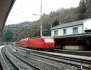
Sihlbrugg railway station
Railway Station in Horgen, Switzerland
Distance: Approx. 4008 meters
Latitude and longitude: 47.2385,8.577
Sihlbrugg is a former railway station in the Swiss Canton of Zürich. It was closed permanently in December 2012, and there are no passenger trains scheduled to stop at the station since then. The station was the terminus of the Sihltal line of SZU (ZVV S4) from 1897 to 2006.
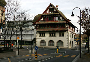
Baar railway station
Railway station in Switzerland
Distance: Approx. 4106 meters
Latitude and longitude: 47.19536194,8.52325
Baar railway station (German: Bahnhof Baar) is a railway station in the Swiss canton of Zug, situated in the municipality of Baar. The station is located on the Thalwil–Arth-Goldau railway and is an intermediate stop for InterRegio trains from Zürich to Lucerne and on Zürich S-Bahn line S24. It is also the northern terminus of the Zug Stadtbahn S1 line.

Baar Neufeld railway station
Swiss railway station
Distance: Approx. 4711 meters
Latitude and longitude: 47.18848056,8.51775
Baar Neufeld railway station (German: Bahnhof Baar Neufeld) is a railway station in the municipality of Baar, in the Swiss canton of Zug. It is an intermediate stop on the standard gauge Thalwil–Arth-Goldau line of Swiss Federal Railways.
Weather in this IP's area
overcast clouds
8 Celsius
8 Celsius
7 Celsius
9 Celsius
1023 hPa
93 %
1023 hPa
944 hPa
10000 meters
0.2 m/s
0.51 m/s
182 degree
100 %
07:06:13
19:34:10