Country:
 Portugal
Region:
City:
Latitude and Longitude:
Time Zone:
Postal Code:
IP information under different IP Channel
ip-api
Country
Region
City
ASN
Time Zone
ISP
Blacklist
Proxy
Latitude
Longitude
Postal
Route
IPinfo
Country
Region
City
ASN
Time Zone
ISP
Blacklist
Proxy
Latitude
Longitude
Postal
Route
MaxMind
Country
Region
City
ASN
Time Zone
ISP
Blacklist
Proxy
Latitude
Longitude
Postal
Route
Luminati
Country
PTRegion
11
City
alvercadoribatejo
ASN
Time Zone
Europe/Lisbon
ISP
Nos Comunicacoes, S.A.
Latitude
Longitude
Postal
db-ip
Country
Region
City
ASN
Time Zone
ISP
Blacklist
Proxy
Latitude
Longitude
Postal
Route
ipdata
Country
Region
City
ASN
Time Zone
ISP
Blacklist
Proxy
Latitude
Longitude
Postal
Route
Popular places and events near this IP address

Vila Franca de Xira
City and municipality in Lisbon, Portugal
Distance: Approx. 5047 meters
Latitude and longitude: 38.95,-8.98333333
Vila Franca de Xira (European Portuguese pronunciation: [ˈvilɐ ˈfɾɐ̃kɐ ðɨ ˈʃiɾɐ] ) is a city and municipality in the Lisbon District in Portugal. The population in 2021 was 137,659, in an area of 318.19 km2. Situated on both banks of the Tagus River, 32 km (20 mi) north-east of the Portuguese capital Lisbon, settlement in the area dates back to neolithic times, as evidenced by findings in the Cave of Pedra Furada.

Alverca do Ribatejo
Civil parish in Lisbon, Portugal
Distance: Approx. 3569 meters
Latitude and longitude: 38.89,-9.04
Alverca do Ribatejo (Portuguese pronunciation: [alˈvɛɾkɐ ðu ʁiβɐˈtɛʒu]) is a city (cidade) and a former civil parish in the municipality of Vila Franca de Xira, Portugal. In 2013, the parish merged into the new parish Alverca do Ribatejo e Sobralinho. It covers an area of 17.89 square kilometres (6.91 sq mi) and as of 2011 had a population of 31,070, making it the largest city in the municipality of Vila Franca de Xira.
Forte da Casa
Town in Vila Franca de Xira, Portugal
Distance: Approx. 6013 meters
Latitude and longitude: 38.872,-9.058
Forte da Casa is a town and former civil parish in the municipality of Vila Franca de Xira, Portugal. Since 2013, it is part of the civil parish Póvoa de Santa Iria e Forte da Casa. Its population in 2011 was 11,056 in an area of 3.96 km2.

Alhandra, São João dos Montes e Calhandriz
Civil parish in Lisbon, Portugal
Distance: Approx. 1769 meters
Latitude and longitude: 38.927,-9.009
Alhandra, São João dos Montes e Calhandriz is a civil parish in the municipality of Vila Franca de Xira, Portugal. It was formed in 2013 by the merger of the former parishes Alhandra, São João dos Montes and Calhandriz. The population in 2011 was 12,866, in an area of 27.54 km2.
Alverca do Ribatejo e Sobralinho
Civil parish in Lisbon, Portugal
Distance: Approx. 2357 meters
Latitude and longitude: 38.901,-9.038
Alverca do Ribatejo e Sobralinho is a civil parish in the municipality of Vila Franca de Xira, Portugal. It was formed in 2013 by the merger of the former parishes Alverca do Ribatejo and Sobralinho. The population in 2011 was 36,120, in an area of 23.92 km2.
Fort of Casa
19th-century fort in Portugal
Distance: Approx. 5718 meters
Latitude and longitude: 38.87444444,-9.05666667
The Fort of Casa was the most easterly of the forts and redoubts built in 1809-10 during the Peninsular War on the second line of the three defensive Lines of Torres Vedras aimed at protecting the capital of Portugal, Lisbon. It is situated in the town of Forte da Casa, in the municipality of Vila Franca de Xira, in the Lisbon District.

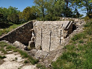
Forts of Serra da Aguieira
19th-century forts in Portugal
Distance: Approx. 4482 meters
Latitude and longitude: 38.89972222,-9.07194444
The Forts of Serra da Aguieira (Hills of Aguieira) were three forts constructed within 100 metres of each other as part of the second line of defence of the so-called Lines of Torres Vedras, which were constructed by Anglo-Portuguese forces in 1810 in order to protect the Portuguese capital Lisbon from possible invasion by the French during the Peninsular War. The forts are situated in the municipality of Vila Franca de Xira, in the Lisbon District of Portugal. From north to south the three forts are the Fort of Aguieira, the Fort of Portela Grande, and the Fort of Portela Pequena.
Fort of Arpim
19th-century fort in Portugal
Distance: Approx. 4820 meters
Latitude and longitude: 38.91194444,-9.08222222
The Fort of Arpim is in the parish of Bucelas in the municipality of Loures, in the Lisbon District of Portugal. It was constructed during the Peninsular War, forming part of the first of three defensive Lines of Torres Vedras aimed at protecting Lisbon, the capital of Portugal, from French invasion. The fort, which never saw battle, has been restored and can be visited.
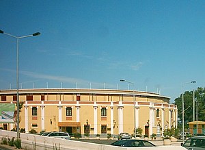
Vila Franca de Xira Bullring
Bullfighting arena in Portugal
Distance: Approx. 4533 meters
Latitude and longitude: 38.94972222,-8.99111111
The Vila Franca de Xira Bullring, also known as the Palha Blanco Bullring (Portuguese: Praça de Touros Palha Blanco) is situated in the centre of the town of Vila Franca de Xira in the municipality of the same name in the Lisbon District of Portugal. It was built in 1901, is still used and is one of the eight “First Category” bullrings in the country. In 1937 the bullring was named after José Pereira Palha Blanco, a cattle raiser, who organised a group of benefactors to form a joint-stock company to fund the building.

Cave of Pedra Furada
Cave and archaeological site in Portugal
Distance: Approx. 5949 meters
Latitude and longitude: 38.96527778,-8.99
The Cave of Pedra Furada is a small cave located in the municipality of Vila Franca de Xira, about 20 km north of Lisbon in Portugal. Archaeological studies conducted within the cave suggest it was occupied intermittently by humans during at least three periods between the end of the fourth millennium BC and the second millennium BC. The cave results from karstification of the limestone Upper Jurassic Massif. The first formal archaeological excavation was carried out in 1955 by a team led by Hipólito Cabaço.

Hermitage of Nossa Senhora de Alcamé
Catholic church in Portugal
Distance: Approx. 5141 meters
Latitude and longitude: 38.90666667,-8.97111111
The Hermitage of Nossa Senhora de Alcamé (Our Lady of Alcamé) (Portuguese: Ermida de Nossa Senhora de Alcamé) is situated on the Lezíria flood plain on the left bank of the River Tagus, in the municipality of Vila Franca de Xira in the Lisbon District of Portugal. Designed by José Manuel de Carvalho e Negreiros, its construction was ordered in 1746 by the First Patriarch of Lisbon, Tomás de Almeida, and continued until around 1755.

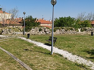
Fort of Subserra
19th-century fort in Portugal
Distance: Approx. 683 meters
Latitude and longitude: 38.92555556,-9.02305556
The Fort of Subserra (No. 1), also known as the Fort of Alhandra, is situated at 142 metres above sea level close to Alhandra in the municipality of Vila Franca de Xira in the Lisbon District of Portugal. Together with other smaller redoubts and batteries that also had the Subserra name, it was built during the Peninsular War (1807–14) as part of the first line of defence of the Lines of Torres Vedras planned by Arthur Wellesley, 1st Duke of Wellington to protect the Portuguese capital of Lisbon and, if necessary, his own retreat.
Weather in this IP's area
few clouds
20 Celsius
20 Celsius
19 Celsius
21 Celsius
1019 hPa
77 %
1019 hPa
1005 hPa
10000 meters
6.69 m/s
310 degree
20 %
07:31:15
19:20:34