Country:
 Portugal
Region:
City:
Latitude and Longitude:
Time Zone:
Postal Code:
IP information under different IP Channel
ip-api
Country
Region
City
ASN
Time Zone
ISP
Blacklist
Proxy
Latitude
Longitude
Postal
Route
IPinfo
Country
Region
City
ASN
Time Zone
ISP
Blacklist
Proxy
Latitude
Longitude
Postal
Route
MaxMind
Country
Region
City
ASN
Time Zone
ISP
Blacklist
Proxy
Latitude
Longitude
Postal
Route
Luminati
Country
PTRegion
11
City
alvercadoribatejo
ASN
Time Zone
Europe/Lisbon
ISP
Nos Comunicacoes, S.A.
Latitude
Longitude
Postal
db-ip
Country
Region
City
ASN
Time Zone
ISP
Blacklist
Proxy
Latitude
Longitude
Postal
Route
ipdata
Country
Region
City
ASN
Time Zone
ISP
Blacklist
Proxy
Latitude
Longitude
Postal
Route
Popular places and events near this IP address
Battle of Alfarrobeira
1449 battle between Portuguese royal forces and those of the rebellious Duke of Coimbra
Distance: Approx. 4771 meters
Latitude and longitude: 38.87107,-9.07793
The Battle of Alfarrobeira (Portuguese pronunciation: [alfɐʁuˈβɐjɾɐ]) took place on 20 May 1449. It was a confrontation between the forces commanded by King Afonso V of Portugal and his uncle Afonso, Duke of Braganza, against the army of the rebellious Peter, Duke of Coimbra. The place was Vialonga, near Lisbon, at the margins of the creek of Alfarrobeira.

Alverca do Ribatejo
Civil parish in Lisbon, Portugal
Distance: Approx. 980 meters
Latitude and longitude: 38.89,-9.04
Alverca do Ribatejo (Portuguese pronunciation: [alˈvɛɾkɐ ðu ʁiβɐˈtɛʒu]) is a city (cidade) and a former civil parish in the municipality of Vila Franca de Xira, Portugal. In 2013, the parish merged into the new parish Alverca do Ribatejo e Sobralinho. It covers an area of 17.89 square kilometres (6.91 sq mi) and as of 2011 had a population of 31,070, making it the largest city in the municipality of Vila Franca de Xira.
Póvoa de Santa Iria e Forte da Casa
Civil parish in Vila Franca de Xira, Portugal
Distance: Approx. 4743 meters
Latitude and longitude: 38.86,-9.06
Póvoa de Santa Iria e Forte da Casa is a civil parish in the municipality of Vila Franca de Xira, Portugal. It was formed in 2013 by the merger of the former parishes Póvoa de Santa Iria and Forte da Casa. The population in 2021 was 40,905, in an area of 9.16 km².
Forte da Casa
Town in Vila Franca de Xira, Portugal
Distance: Approx. 3505 meters
Latitude and longitude: 38.872,-9.058
Forte da Casa is a town and former civil parish in the municipality of Vila Franca de Xira, Portugal. Since 2013, it is part of the civil parish Póvoa de Santa Iria e Forte da Casa. Its population in 2011 was 11,056 in an area of 3.96 km2.

Alhandra, São João dos Montes e Calhandriz
Civil parish in Lisbon, Portugal
Distance: Approx. 3945 meters
Latitude and longitude: 38.927,-9.009
Alhandra, São João dos Montes e Calhandriz is a civil parish in the municipality of Vila Franca de Xira, Portugal. It was formed in 2013 by the merger of the former parishes Alhandra, São João dos Montes and Calhandriz. The population in 2011 was 12,866, in an area of 27.54 km2.
Alverca do Ribatejo e Sobralinho
Civil parish in Lisbon, Portugal
Distance: Approx. 432 meters
Latitude and longitude: 38.901,-9.038
Alverca do Ribatejo e Sobralinho is a civil parish in the municipality of Vila Franca de Xira, Portugal. It was formed in 2013 by the merger of the former parishes Alverca do Ribatejo and Sobralinho. The population in 2011 was 36,120, in an area of 23.92 km2.

Póvoa de Santa Iria
City in Vila Franca de Xira, Portugal
Distance: Approx. 4965 meters
Latitude and longitude: 38.862,-9.069
Póvoa de Santa Iria is a city and former civil parish in the municipality of Vila Franca de Xira, Portugal. Since 2013, it is part of the civil parish Póvoa de Santa Iria e Forte da Casa. Its population in 2011 was 29,348.
Fort of Casa
19th-century fort in Portugal
Distance: Approx. 3216 meters
Latitude and longitude: 38.87444444,-9.05666667
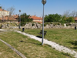
The Fort of Casa was the most easterly of the forts and redoubts built in 1809-10 during the Peninsular War on the second line of the three defensive Lines of Torres Vedras aimed at protecting the capital of Portugal, Lisbon. It is situated in the town of Forte da Casa, in the municipality of Vila Franca de Xira, in the Lisbon District.

Forts of Serra da Aguieira
19th-century forts in Portugal
Distance: Approx. 3207 meters
Latitude and longitude: 38.89972222,-9.07194444
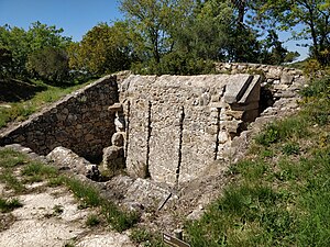
The Forts of Serra da Aguieira (Hills of Aguieira) were three forts constructed within 100 metres of each other as part of the second line of defence of the so-called Lines of Torres Vedras, which were constructed by Anglo-Portuguese forces in 1810 in order to protect the Portuguese capital Lisbon from possible invasion by the French during the Peninsular War. The forts are situated in the municipality of Vila Franca de Xira, in the Lisbon District of Portugal. From north to south the three forts are the Fort of Aguieira, the Fort of Portela Grande, and the Fort of Portela Pequena.
Fort of Arpim
19th-century fort in Portugal
Distance: Approx. 4379 meters
Latitude and longitude: 38.91194444,-9.08222222
The Fort of Arpim is in the parish of Bucelas in the municipality of Loures, in the Lisbon District of Portugal. It was constructed during the Peninsular War, forming part of the first of three defensive Lines of Torres Vedras aimed at protecting Lisbon, the capital of Portugal, from French invasion. The fort, which never saw battle, has been restored and can be visited.

Fort of Subserra
19th-century fort in Portugal
Distance: Approx. 3248 meters
Latitude and longitude: 38.92555556,-9.02305556
The Fort of Subserra (No. 1), also known as the Fort of Alhandra, is situated at 142 metres above sea level close to Alhandra in the municipality of Vila Franca de Xira in the Lisbon District of Portugal. Together with other smaller redoubts and batteries that also had the Subserra name, it was built during the Peninsular War (1807–14) as part of the first line of defence of the Lines of Torres Vedras planned by Arthur Wellesley, 1st Duke of Wellington to protect the Portuguese capital of Lisbon and, if necessary, his own retreat.

Vialonga, Portugal
Town and civil parish in Vila Franca de Xira, Portugal
Distance: Approx. 4865 meters
Latitude and longitude: 38.874,-9.082
Vialonga is a town and civil parish in the municipality of Vila Franca de Xira, Portugal. Its population in 2021 was 21,261.
Weather in this IP's area
few clouds
21 Celsius
21 Celsius
19 Celsius
22 Celsius
1019 hPa
79 %
1019 hPa
1018 hPa
10000 meters
6.69 m/s
310 degree
20 %
07:31:17
19:20:37