Country:
 Portugal
Region:
City:
Latitude and Longitude:
Time Zone:
Postal Code:
IP information under different IP Channel
ip-api
Country
Region
City
ASN
Time Zone
ISP
Blacklist
Proxy
Latitude
Longitude
Postal
Route
IPinfo
Country
Region
City
ASN
Time Zone
ISP
Blacklist
Proxy
Latitude
Longitude
Postal
Route
MaxMind
Country
Region
City
ASN
Time Zone
ISP
Blacklist
Proxy
Latitude
Longitude
Postal
Route
Luminati
Country
PTRegion
08
City
portimao
ASN
Time Zone
Europe/Lisbon
ISP
Nos Comunicacoes, S.A.
Latitude
Longitude
Postal
db-ip
Country
Region
City
ASN
Time Zone
ISP
Blacklist
Proxy
Latitude
Longitude
Postal
Route
ipdata
Country
Region
City
ASN
Time Zone
ISP
Blacklist
Proxy
Latitude
Longitude
Postal
Route
Popular places and events near this IP address
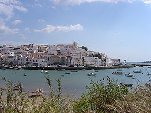
Portimão
Municipality in Algarve, Portugal
Distance: Approx. 439 meters
Latitude and longitude: 37.13694444,-8.53833333
Portimão (European Portuguese pronunciation: [puɾtiˈmɐ̃w] ) is a city and a municipality in the district of Faro, in the Algarve region of southern Portugal. The population in 2022 was 60,879, in an area of 182.06 km2. It was formerly known as Vila Nova de Portimão.

Praia da Rocha
Beach in Algarve, Portugal
Distance: Approx. 2230 meters
Latitude and longitude: 37.11666667,-8.53333333
Praia da Rocha (English: "Rock Beach") is a beach and built up area on the Atlantic Ocean in the southern section of the concelho of Portimão, Algarve, southern Portugal. On the eastern edge of the beach stands the Fort of Santa Catarina (Portimão). A 17th century fortress built to defend the mouth of the Arade River.
Arade River
River of the Algarve, Portugal
Distance: Approx. 2980 meters
Latitude and longitude: 37.111,-8.524
The Arade (Portuguese pronunciation: [ɐˈɾaðɨ]) is a river located in the region of the Algarve, southern Portugal. the river's course takes it through the municipalities of Silves, Lagoa and Portimão. The source of the river lies to the southwest of the Serra do Caldeirão mountain ridge, in a valley called Barranco do Pé do Coelho.
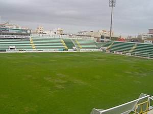
Estádio Municipal de Portimão
Stadium in Portimão, Portugal
Distance: Approx. 569 meters
Latitude and longitude: 37.13583333,-8.53972222
Estádio Municipal de Portimão is the current stadium of Portimonense S.C. It is located in the centre of Portimão in the Algarve, Portugal and was opened in 1937 for local football club Portimonense S.C. Its capacity is 4,961 people. It hosted Portimonense's stay in the Primeira Liga in the 1980s. In 2006, Portimonense were forced to play away from the Estádio Municipal in the Estádio Algarve, which – built for Euro 2004 – is 70 kilometres from Portimão.
Ferragudo
Civil parish in Algarve, Portugal
Distance: Approx. 1792 meters
Latitude and longitude: 37.124,-8.521
Ferragudo is a Portuguese civil parish at the western border of the municipality of Lagoa. The population in 2011 was 1,973, in an area of 5.41 km2. Ferragudo serves mainly as a bedroom community for its much larger neighbour, the city of Portimão; its residents routinely travel across the Arade River to work in the neighboring municipality.

Fort of São João do Arade
Distance: Approx. 2133 meters
Latitude and longitude: 37.11959722,-8.52255833
The Fort of São João do Arade (Portuguese: Forte de São João do Arade), sometimes referred to as the Castle of Arade, is a medieval fortification situated in the civil parish of Ferragudo in the Portuguese Algarve municipality of Lagoa.

Praia Grande (Ferragudo)
Distance: Approx. 2107 meters
Latitude and longitude: 37.12,-8.52222222
Praia Grande (Big Beach) is a beach situated in the civil parish of Ferragudo, municipality of Lagoa, the Portuguese Algarve. One of many beaches to obtain the name Praia Grande, this coastal zone is located on the eastern back of Rio Arade estuary, south of the town of Ferragudo. It is just inside the mole that shields the river entrance and the port area of Portimão, and runs north to the Forte de Sao João do Arade.

Fort of Santa Catarina (Portimão)
Distance: Approx. 2292 meters
Latitude and longitude: 37.11633889,-8.52959444
The Fort of Santa Catarina (also known as the Fort of Santa Catarina de Ribamar) is a medieval fort situated in the civil parish of Portimão, in the municipality of Portimão in Portuguese Algarve. The structure was considered one of the last Philippine military projects in the Algarve, erected to defend the peninsula from pirates and privateers, as well as military invasions. Its construction is one of the better examples that work of Alexandre Massai, a military engineer who toured the Algarve (between 1617 and 1621) to reinforce numerous military fortifications along the coast.
Parchal
Civil parish in Algarve, Portugal
Distance: Approx. 1879 meters
Latitude and longitude: 37.13666667,-8.51222222
Parchal is a town and a former civil parish in the municipality (concelho) of Lagoa, Portugal. In 2013, the parish merged into the new parish Estômbar e Parchal. The population in 2011 was 4,019, in an area of 3.86 km2.
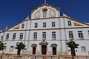
Portimão (parish)
Civil parish in Algarve, Portugal
Distance: Approx. 409 meters
Latitude and longitude: 37.139,-8.537
Portimão is a freguesia (parish) in the municipality of Portimão (Algarve, Portugal). The population in 2011 was 45,431, in an area of 75.66 km².

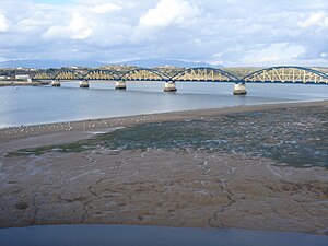
Portimão railway station
Distance: Approx. 952 meters
Latitude and longitude: 37.1446,-8.5375
Portimão station (Portuguese: Estação de Portimão) is the main railway station in the city of Portimão, Portugal, operated by Comboios de Portugal. It opened on 30 July 1922.

Ferragudo halt
Railway halt in Portugal
Distance: Approx. 1285 meters
Latitude and longitude: 37.13872222,-8.51914722
Ferragudo is a halt on the Algarve Line in the Lagoa municipality, Portugal. It was opened on 15 February 1903, under the name Portimão. After the construction and opening of the Portimão Railway Bridge and station, in 1922, the name was changed to Ferragudo.
Weather in this IP's area
overcast clouds
22 Celsius
22 Celsius
22 Celsius
22 Celsius
1018 hPa
60 %
1018 hPa
1017 hPa
10000 meters
4.41 m/s
6.36 m/s
334 degree
100 %
07:28:47
19:19:06