Country:
 Ireland
Region:
City:
Latitude and Longitude:
Time Zone:
Postal Code:
IP information under different IP Channel
ip-api
Country
Region
City
ASN
Time Zone
ISP
Blacklist
Proxy
Latitude
Longitude
Postal
Route
IPinfo
Country
Region
City
ASN
Time Zone
ISP
Blacklist
Proxy
Latitude
Longitude
Postal
Route
MaxMind
Country
Region
City
ASN
Time Zone
ISP
Blacklist
Proxy
Latitude
Longitude
Postal
Route
Luminati
Country
IERegion
m
City
cork
ASN
Time Zone
Europe/Dublin
ISP
Liberty Global B.V.
Latitude
Longitude
Postal
db-ip
Country
Region
City
ASN
Time Zone
ISP
Blacklist
Proxy
Latitude
Longitude
Postal
Route
ipdata
Country
Region
City
ASN
Time Zone
ISP
Blacklist
Proxy
Latitude
Longitude
Postal
Route
Popular places and events near this IP address

Cork College of Commerce
College in Cork, Ireland
Distance: Approx. 135 meters
Latitude and longitude: 51.8957,-8.4694
Cork College of Commerce is a college that was established in December 1908 in Cork, Ireland. It was originally named the "School of Commerce and Domestic Science".

Cork (city)
City in County Cork, Munster, Ireland
Distance: Approx. 130 meters
Latitude and longitude: 51.89722222,-8.47
Cork (Irish: Corcaigh [ˈkɔɾˠkəɟ]; from corcach, meaning 'marsh') is the second largest city in the Republic of Ireland, the county town of County Cork, the largest city in the province of Munster and third largest on the island of Ireland. At the 2022 census, it had a population of 224,004. The city centre is an island between two channels of the River Lee which meet downstream at its eastern end, where the quays and docks along the river lead outwards towards Lough Mahon and Cork Harbour, one of the largest natural harbours in the world.

Irish Industrial Exhibition
1852 world's fair
Distance: Approx. 204 meters
Latitude and longitude: 51.8971,-8.4654
The Irish Industrial Exhibition was a world's fair held in Cork in 1852, the first to be held in Ireland (then part of the United Kingdom). It was opened on 10 June by the Lord Lieutenant, the Earl of Eglinton. Taking place two years after the Great Famine ended, and following a significant increase in Cork's population due to an influx of people fleeing the countryside the fair stemmed partly from attempts to revive local industries.

Oliver Plunkett Street
Street in central Cork, Ireland
Distance: Approx. 209 meters
Latitude and longitude: 51.898,-8.4705
Oliver Plunkett Street (Irish: Sráid Olibhéir Pluincéid) is a shopping street in Cork, Ireland. It was originally laid-out in the early 18th century as the city expanded eastwards beyond the original city walls.

South Mall, Cork
Distance: Approx. 106 meters
Latitude and longitude: 51.8971,-8.4697
South Mall (Irish: An Meall Theas) is one of the main streets of Cork city, Ireland. It runs from Grand Parade in the west to Parnell Place in the east. Like Grand Parade and St.

Holy Trinity Church, Cork
Church in Cork, Republic of Ireland
Distance: Approx. 219 meters
Latitude and longitude: 51.895553,-8.4708917
Holy Trinity Church, also known as Father Mathew Memorial Church, is a Roman Catholic Gothic Revival church and friary on Fr. Mathew Quay, on the bank of the River Lee in Cork. It belongs to the Order of Friars Minor Capuchin and is the only church dedicated to Father Theobald Mathew.

City Hall, Cork
Municipal building in Cork city, Ireland
Distance: Approx. 204 meters
Latitude and longitude: 51.8971,-8.4654
The City Hall, Cork (Irish: Halla na Cathrach, Corcaigh) is a civic building in Cork, Ireland which houses the administrative headquarters of Cork City Council.

Theatre Royal, Cork
Distance: Approx. 195 meters
Latitude and longitude: 51.8978,-8.4705
The Theatre Royal was a patent theatre located in Cork City, Ireland.
RTÉ Radio Cork
Radio station in Cork, Ireland
Distance: Approx. 80 meters
Latitude and longitude: 51.895979,-8.468332
RTÉ Radio Cork, also known as RTÉ Cork Local Radio and Cork 89FM, was a local radio station in the Republic of Ireland serving Cork City. The FM signal spilled into Ballincollig and Carrigaline, but the rest of County Cork had to rely on the medium wave signal. It was shut down in 2000.

Cork Courthouse, Anglesea Street
Schoolhouse converted to court facility
Distance: Approx. 148 meters
Latitude and longitude: 51.8962,-8.4663
Cork Courthouse, Anglesea Street (Irish: Teach Cúirte Chorcaí, Sráid Anglesea) is a judicial facility on Anglesea Street, Cork, Ireland. It serves as the Cork Court Office for matters of crime, while the courthouse on Washington Street serves as the court office for civil and family matters. The Anglesea Sreet courthouse operates at the level of the District and Circuit Courts, and holds six courtrooms.
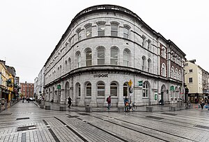
Cork General Post Office
Cork's General Post Office
Distance: Approx. 196 meters
Latitude and longitude: 51.89791,-8.47037
Cork General Post Office (GPO) is a historic post office building in Oliver Plunkett Street in Cork, Ireland. Built on the site of an older theatre, it is one of the few An Post offices in Ireland which still retains the General Post Office moniker from the times when the Irish postal service was under the governance of the British General Post Office. The post office is one of Oliver Plunkett Street's most prominent buildings, and is listed as a protected structure.
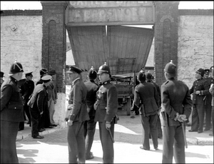
Copley Street riot
1934 riot in Cork, Ireland
Distance: Approx. 208 meters
Latitude and longitude: 51.8952,-8.4665
The Copley Street riot occurred on 13 August 1934, at the Copley Street Repository, Cork, Ireland after Blueshirts opposed to the collection of annuities from auctioned cattle rammed a truck through the gate of an ongoing cattle auction. The Broy Harriers opened fire and one man, 22 year old Michael Lynch, was killed and several others injured.
Weather in this IP's area
overcast clouds
15 Celsius
15 Celsius
15 Celsius
15 Celsius
1006 hPa
100 %
1006 hPa
1005 hPa
3000 meters
8.23 m/s
14.92 m/s
190 degree
100 %
08:04:00
18:33:35