Country:
 Serbia
Region:
City:
Latitude and Longitude:
Time Zone:
Postal Code:
IP information under different IP Channel
ip-api
Country
Region
City
ASN
Time Zone
ISP
Blacklist
Proxy
Latitude
Longitude
Postal
Route
IPinfo
Country
Region
City
ASN
Time Zone
ISP
Blacklist
Proxy
Latitude
Longitude
Postal
Route
MaxMind
Country
Region
City
ASN
Time Zone
ISP
Blacklist
Proxy
Latitude
Longitude
Postal
Route
Luminati
Country
RSRegion
vo
City
pancevo
ASN
Time Zone
Europe/Belgrade
ISP
CETIN Ltd. Belgrade
Latitude
Longitude
Postal
db-ip
Country
Region
City
ASN
Time Zone
ISP
Blacklist
Proxy
Latitude
Longitude
Postal
Route
ipdata
Country
Region
City
ASN
Time Zone
ISP
Blacklist
Proxy
Latitude
Longitude
Postal
Route
Popular places and events near this IP address
Utva Aviation Industry
Serbian aircraft manufacturer
Distance: Approx. 3318 meters
Latitude and longitude: 44.89805556,20.63330556
Utva Aviation Industry (Serbian: Утва Авио Индустрија, romanized: Utva Avio Industrija), commonly known as UTVA is a Serbian manufacturer of general aviation aircraft, subsidiary of Yugoimport SDPR, headquartered in Pančevo.

Pančevo
City in the province of Vojvodina, Serbia
Distance: Approx. 433 meters
Latitude and longitude: 44.87055556,20.64027778
Pančevo (Serbian Cyrillic: Панчево, pronounced [pâːntʃeʋo]; ‹See Tfd›German: Pantschowa; Hungarian: Pancsova; Romanian: Panciova; Slovak: Pánčevo) is a city and the administrative center of the South Banat District in the autonomous province of Vojvodina, Serbia. It is located on the shores of rivers Tamiš and Danube, in the southern part of Banat region. Since the 2022 census 115,454 people have been living in the Pančevo administrative area.

South Banat District
District of Serbia
Distance: Approx. 266 meters
Latitude and longitude: 44.86666667,20.63333333
The South Banat District (Serbian: Јужнобанатски округ, romanized: Južnobanatski okrug, pronounced [jûʒnobǎnaːtskiː ôkruːɡ]; Hungarian: Dél-bánsági körzet; Romanian: Districtul Banatul de Sud; Slovak: Juhobanátsky okres) is one of seven administrative districts of the autonomous province of Vojvodina, Serbia. The administrative center of the district is the city of Pančevo. The district lies in the region of Banat.

Timiș
River in Romania and Serbia
Distance: Approx. 2254 meters
Latitude and longitude: 44.84805556,20.63555556
The Timiș or Tamiš (Romanian: Timiș, Serbian: Тамиш, Hungarian: Temes, ‹See Tfd›German: Temesch) is a 359-kilometre-long (223 mi) river that flows through the Banat region of Romania and Serbia and joins the Danube near Pančevo, in northern Serbia. Due to its position in the region, it has been labeled as the "spine of the Banat".
Pančevo Airport
Airport
Distance: Approx. 3776 meters
Latitude and longitude: 44.90222222,20.63527778
Pančevo Airport (Аеродром Панчево or Aerodrom Pančevo) (ICAO: LYPA) is an airport near the city of Pančevo, Serbia near Belgrade. The airport is mostly used for general aviation operations. It has a single grass runway 1,000 metres long and 60 metres wide.

Bela Stena
Distance: Approx. 4379 meters
Latitude and longitude: 44.8488,20.5876
Bela Stena (Serbian: Бела Стена) is an island resort in the Danube, located in the city of Pančevo in Serbia.

Vojlovica Monastery
Distance: Approx. 6487 meters
Latitude and longitude: 44.83166667,20.69972222
The Vojlovica Monastery (Serbian: Манастир Војловица, romanized: Manastir Vojlovica) is a Serb Orthodox monastery situated in the Banat region, in the northern Serbian province of Vojvodina. It is in the Pančevo municipality. It was founded during the time of Despot Stefan Lazarević (1374-1427).

Forkontumac
Distance: Approx. 3042 meters
Latitude and longitude: 44.848,20.61
Forkontumac (Serbian Cyrillic: Форконтумац) is a river island in Serbia, located on the Danube, east of Belgrade and north of the neighbouring island Čakljanac. Both islands are the southernmost part of Pančevo. The island has an area of 391,7 hectares.
Čakljanac
Distance: Approx. 4842 meters
Latitude and longitude: 44.825,20.63
Čakljanac (Serbian Cyrillic: Чакљанац) is a river island located on the Danube in Serbia, south of another river island Forkontumac and the city of Pančevo.
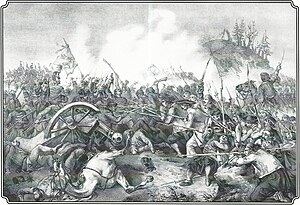
Battle of Pancsova
First battle of the Hungarian War of Independence 1848
Distance: Approx. 2155 meters
Latitude and longitude: 44.88713889,20.6295
The Battle of Pancsova (now Pančevo, in the Pančevo municipality in the South Banat District Serbia) was a battle in the Hungarian War of Independence of 1848-1849, fought on 2 January 1849 between the Hungarian Army under the command of Lieutenant General Ernő Kiss against the Serbian insurgents led by Colonel Ferdinand Mayerhofer von Grünhübel. Pancsova was the last important Serbian stronghold in the Bánság/Banat region of Southern Hungary, after the Hungarian victories at Alibunar and Jarkovác. Because of the bad timing of the attack, the insufficient numbers of soldiers, and their clothing inappropriate for the very cold weather, Kiss's army was defeated, and forced to retreat.

Pančevo executions
Killing of Serb civilians in 1941
Distance: Approx. 433 meters
Latitude and longitude: 44.87055556,20.64027778
The Pančevo executions (Serbo-Croatian Latin: Pokolj u Pančevu; Serbian Cyrillic: Пoкoлј у Панчеву) were the summary execution of 36 Serb civilians in Pančevo from 21 to 22 April 1941, during World War II. The executions were carried out by the German army, in particular elements of the Panzergrenadier Division Großdeutschland, with the assistance of the Waffen SS, in particular elements of the 2nd SS Panzer Division Das Reich. The executions were also supported and facilitated by local Germans, in particular members of the Kulturbund. The executions came about in response to an alleged ambush by local Serbs on elements of the German army.

Church of the Assumption of the Theotokos
Church in Vojvodina, Serbia
Distance: Approx. 490 meters
Latitude and longitude: 44.87222222,20.63861111
The Church of the Assumption of the Theotokos (Serbian: Црква успења пресвете Богородице) in Pančevo is Serbian Orthodox church in Vojvodina, Serbia. It is listed as a Monument of Great Cultural Importance by the Republic of Serbia. The church was built between 1801 and 1810 with contributions from local benefactors, among whom was Karađorđe Petrović, the leader of the First Serbian Uprising.
Weather in this IP's area
few clouds
13 Celsius
12 Celsius
12 Celsius
13 Celsius
1014 hPa
86 %
1014 hPa
1005 hPa
10000 meters
1.27 m/s
1.38 m/s
324 degree
14 %
06:40:26
18:10:54