Country:
Region:
City:
Latitude and Longitude:
Time Zone:
Postal Code:
IP information under different IP Channel
ip-api
Country
Region
City
ASN
Time Zone
ISP
Blacklist
Proxy
Latitude
Longitude
Postal
Route
Luminati
Country
ASN
Time Zone
Europe/Paris
ISP
SEWAN SAS
Latitude
Longitude
Postal
IPinfo
Country
Region
City
ASN
Time Zone
ISP
Blacklist
Proxy
Latitude
Longitude
Postal
Route
db-ip
Country
Region
City
ASN
Time Zone
ISP
Blacklist
Proxy
Latitude
Longitude
Postal
Route
ipdata
Country
Region
City
ASN
Time Zone
ISP
Blacklist
Proxy
Latitude
Longitude
Postal
Route
Popular places and events near this IP address

Berlin Wall
Barrier that once enclosed West Berlin
Distance: Approx. 706 meters
Latitude and longitude: 52.50444444,13.44111111
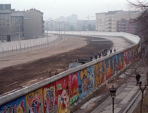
The Berlin Wall (German: Berliner Mauer, pronounced [bɛʁˌliːnɐ ˈmaʊɐ] ) was a guarded concrete barrier that encircled West Berlin from 1961 to 1989, separating it from East Berlin and the German Democratic Republic (GDR; East Germany). Construction of the Berlin Wall was commenced by the government of the GDR on 13 August 1961. It included guard towers placed along large concrete walls, accompanied by a wide area (later known as the "death strip") that contained anti-vehicle trenches, beds of nails and other defenses.
Weberwiese (Berlin U-Bahn)
Station of the Berlin U-Bahn
Distance: Approx. 803 meters
Latitude and longitude: 52.51666667,13.445
Weberwiese is a Berlin U-Bahn station located on the U5 line, which currently runs from Berlin Central Station to Hönow. The station is located under Karl-Marx-Allee directly east of Straße der Pariser Kommune. Although the next station on the line is called Frankfurter Tor, the historical city gate Frankfurter Tor actually stood at the location of the Weberwiese station.

Berghain
Nightclub in Berlin
Distance: Approx. 307 meters
Latitude and longitude: 52.51111111,13.44305556
Berghain (German: [ˈbɛʁkhaɪn]) is a nightclub in Berlin, Germany. It is named after its location near the border between Kreuzberg and Friedrichshain in Berlin, and is a short walk from Berlin Ostbahnhof main line railway station.

Berlin Ostbahnhof
Railway station in Berlin, Germany
Distance: Approx. 271 meters
Latitude and longitude: 52.51,13.43472222
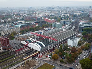
Berlin Ostbahnhof (German for Berlin East railway station) is a main line railway station in Berlin, Germany. It is located in the Friedrichshain quarter, now part of Friedrichshain-Kreuzberg borough, and has undergone several name changes in its history. It was known as Berlin Hauptbahnhof from 1987 to 1998, a name now applied to Berlin's new central station at the former Lehrter station.

Uber Arena
Multipurpose indoor arena in Berlin, Germany
Distance: Approx. 647 meters
Latitude and longitude: 52.50555556,13.44333333
Uber Arena (previously branded as O2 World and Mercedes-Benz Arena) is a multipurpose indoor arena in the Friedrichshain neighborhood of Berlin, Germany, which opened in 2008. The venue became known as Uber Arena following a long-term deal with venue operators AEG Europe in 2024. With a maximum capacity of 17,000 people (for concerts or MMA), it is home to the Eisbären Berlin ice hockey club and the Alba Berlin basketball team, and is used for other athletic and civic events, as well as concerts.

Straße der Pariser Kommune
Street in Berlin, Germany
Distance: Approx. 212 meters
Latitude and longitude: 52.5125,13.43861111
The Straße der Pariser Kommune is a street in Friedrichshain, Berlin, Germany. It was known as Fruchtstraße until March 17, 1971, when it was renamed to commemorate the 100th anniversary of the Paris Commune. The road begins at the meeting point of Mühlenstrasse and Straulauer Platz, which run parallel to the River Spree, and continues north along the rails of the Ostbahnhof to the Karl-Marx-Allee.

Berlin Wriezener Bahnhof
Railway station in Berlin, Germany
Distance: Approx. 101 meters
Latitude and longitude: 52.51027778,13.44
Berlin Wriezener Bahnhof was a passenger railway terminus in Berlin, Germany. The station was situated close to the modern Ostbahnhof, and its goods station (Wriezener Güterbahnhof) was extended between it and Warschauer Straße station. From 1867 to 1882, nearby the Wriezener Bahnhof, Old Ostbahnhof functioned as a passenger terminal.

Berlin Old Ostbahnhof
Former railway station in Berlin, Germany
Distance: Approx. 164 meters
Latitude and longitude: 52.51166667,13.44027778
The old Berlin Ostbahnhof, more commonly referred to as Küstriner Bahnhof, was a short-lived passenger railway terminus in Berlin, Germany, opened on 1 October 1867 as the terminus of the Prussian Eastern Railway (Ostbahn) to Küstrin (now Kostrzyn) and Königsberg (Kaliningrad).
Computerspielemuseum
Video game museum in Berlin, Germany
Distance: Approx. 811 meters
Latitude and longitude: 52.5176,13.4419
The Computerspielemuseum (German for Computer Game Museum) is a German video game museum founded in 1997. From 1997 to 2000, it had a permanent exhibition in Berlin. Afterward, it became an online-only museum.

Hochhaus an der Weberwiese
Residential in Berlin-Friedrichshain, Germany
Distance: Approx. 608 meters
Latitude and longitude: 52.515036,13.443846
The Hochhaus an der Weberwiese (literally "high house on the weaver's meadow") is a residential building in Berlin, located in the district of Friedrichshain. Built as part of the plan for post-war reconstruction, it was the first example of socialist classicism in the German Democratic Republic.
Uber Eats Music Hall
Music hall in Berlin, Germany
Distance: Approx. 683 meters
Latitude and longitude: 52.50527778,13.44361111
The Uber Eats Music Hall, formerly known as the Verti Music Hall, is a music hall located on Mercedes-Platz in Berlin. Since it opened in 2018, up to 4,500 spectators have been able to attend concerts, shows and corporate events there. In January 2024, it was announced that the ride-hailing company Uber had secured the naming rights and that the hall would be renamed Uber Eats Music Hall from 22 March 2024.

Friedrichshain Combined Heat and Power Plant
Former heat and power generating plant
Distance: Approx. 307 meters
Latitude and longitude: 52.51111111,13.44305556
The Friedrichshain combined heat and power plant is also is located at Rüdersdorfer Straße in the district Berlin-Friedrichshain. Today the building is widely known as the location of the techno club Berghain. The conversion from cogeneration plant to nightclub took place in 2003/04 and was supervised by the design firm Studio Karhard – led by architects Alexandra Erhard and Thomas Karsten.
Weather in this IP's area
overcast clouds
6 Celsius
4 Celsius
5 Celsius
7 Celsius
1023 hPa
94 %
1023 hPa
1019 hPa
10000 meters
3.58 m/s
4.47 m/s
273 degree
100 %
07:28:37
16:13:24

