Country:
 Finland
Region:
City:
Latitude and Longitude:
Time Zone:
Postal Code:
IP information under different IP Channel
ip-api
Country
Region
City
ASN
Time Zone
ISP
Blacklist
Proxy
Latitude
Longitude
Postal
Route
IPinfo
Country
Region
City
ASN
Time Zone
ISP
Blacklist
Proxy
Latitude
Longitude
Postal
Route
MaxMind
Country
Region
City
ASN
Time Zone
ISP
Blacklist
Proxy
Latitude
Longitude
Postal
Route
Luminati
Country
FIASN
Time Zone
Europe/Helsinki
ISP
Dustin Finland Oy
Latitude
Longitude
Postal
db-ip
Country
Region
City
ASN
Time Zone
ISP
Blacklist
Proxy
Latitude
Longitude
Postal
Route
ipdata
Country
Region
City
ASN
Time Zone
ISP
Blacklist
Proxy
Latitude
Longitude
Postal
Route
Popular places and events near this IP address

Helsinki Airport
Airport in Finland
Distance: Approx. 671 meters
Latitude and longitude: 60.31722222,24.96333333
Helsinki-Vantaa Airport (Finnish: Helsinki-Vantaan lentoasema, Swedish: Helsingfors-Vanda flygplats) (IATA: HEL, ICAO: EFHK), or simply Helsinki Airport, is the main international airport serving Helsinki, the capital of Finland, as well as its surrounding metropolitan area, and the Uusimaa region in Finland. The airport is located in the neighbouring city of Vantaa, about 5 kilometres (3 mi) west of Tikkurila, the administrative centre of Vantaa and 9.2 NM (17.0 km; 10.6 mi) north of Helsinki's city centre. The airport is operated by state-owned Finavia.

Finavia
Distance: Approx. 489 meters
Latitude and longitude: 60.31555556,24.96527778
Finavia Oyj, formerly the Finnish Civil Aviation Administration, is the public limited company responsible for maintaining and developing Finland's airport network. Finavia manages and develops 20 airports around the country, 18 of which primarily serve commercial flights and 2 of which focus solely on military and general aviation. Finavia is owned by the Finnish Government.

Finnish Aviation Museum
Aviation museum in Vantaa, Finland
Distance: Approx. 1283 meters
Latitude and longitude: 60.30421667,24.96086667
The Finnish Aviation Museum (Finnish: Suomen ilmailumuseo, Swedish: Finlands flygmuseum) is a museum specialising in aircraft, located near Helsinki Airport in Veromies, Vantaa, Finland.

Aviapolis
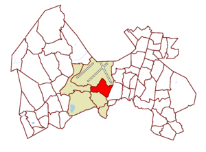
Major Region of Vantaa in Finland
Distance: Approx. 2018 meters
Latitude and longitude: 60.3,24.95
Aviapolis is a business, retail, entertainment, and housing marketing brand area in central Vantaa, Finland, covering roughly 40 square kilometres (15 sq mi), including Finland's main airline hub and airport, Helsinki Airport. The term is officially used as the name of one of the major regions of Vantaa, encompassing the districts of Lentokenttä, Pakkala, Tammisto, Veromies, Viinikkala, and Ylästö. It is Vantaa's only major region not named after a city district.
Veromies
City District in Finland
Distance: Approx. 1931 meters
Latitude and longitude: 60.29722222,24.96388889
Veromies (Swedish: Skattmans) (meaning "taxman") is a city district in Vantaa, Finland. It is located in southeastern Vantaa, in the Aviapolis major region. It is situated south of Helsinki Airport and west of the Tuusulanväylä highway.

Lentokenttä
City District in Finland
Distance: Approx. 671 meters
Latitude and longitude: 60.31722222,24.96333333
Lentokenttä (Swedish: Flygfältet; English meaning: “airfield”) is a district of Vantaa, Finland, located in the middle of the city. The district is part of the Aviapolis major region and has been named after the Helsinki Airport situated there. The district of Lentokenttä is the largest single job concentration of Vantaa.

Jumbo shopping centre
Shopping mall in Vantaa, Finland
Distance: Approx. 2590 meters
Latitude and longitude: 60.291053,24.964636
Jumbo- Flamingo shopping centre (Finnish: Kauppakeskus Jumbo- Flamingo), commonly referred to as simply Jumbo, is a shopping center in Vantaa, Finland. With its gross leasable area of 86,100 square metres (927,000 sq ft), it is the second largest shopping and entertainment center in the Nordics. Jumbo was completed in October 1999.
Aviapolis railway station
Railway station in Vantaa, Finland
Distance: Approx. 1428 meters
Latitude and longitude: 60.3041,24.9568
Aviapolis railway station (Finnish: Aviapoliksen rautatieasema, Swedish: Aviapolis järnvägsstation) is a Helsinki commuter rail station located in the area of Aviapolis in Vantaa, Finland. It is one of the new stations of the Ring Rail Line (Kehärata), which opened in July 2015. The station is located between the stations of Kivistö and Lentoasema (Helsinki Airport).

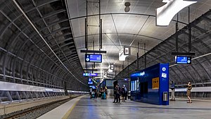
Helsinki Airport station
Railway station in Vantaa, Finland
Distance: Approx. 354 meters
Latitude and longitude: 60.31611111,24.96888889
Helsinki Airport station (Finnish: Lentoaseman rautatieasema, Swedish: Flygplatsens järnvägsstation) is a Helsinki commuter rail station located at Helsinki Airport in Vantaa, Finland. Helsinki Airport station is on the Ring Rail Line, located between the stations of Aviapolis and Leinelä. It is the world's northernmost underground railway station.
Lentorata
Planned Helsinki Airport rail link
Distance: Approx. 242 meters
Latitude and longitude: 60.3158869,24.97172319
Lentorata (Airport Line) is a planned railway line in Finland, designed to link Helsinki Airport to the Finnish long-distance railway network and to complement the current airport connection via the Ring Rail Line. Construction of the line is not expected to start until 2030, with the line operational several years later.
Ruskeasanta
City District in Finland
Distance: Approx. 1709 meters
Latitude and longitude: 60.30996389,25.00346944
Ruskeasanta (Finnish: [ˈruskeɑˌsɑntɑ]; Swedish: Rödsand) is a city district in Vantaa, Finland. It is part of the Tikkurila major region, located about 5 kilometres (3.1 mi) east of the Helsinki Airport. The district is known mainly as a residential area preferred by families with children.
Simosenkylä
Illegal village in Vantaa, Finland
Distance: Approx. 1748 meters
Latitude and longitude: 60.32666944,24.99194722
Simosenkylä is an illegal village in Vantaa, Finland. It is located in the forest area between Helsinki Airport and Tuusula Highway, along the Simosentie road. The village consists of one-story houses, which are badly dilapidated, some even abandoned.
Weather in this IP's area
clear sky
14 Celsius
14 Celsius
13 Celsius
16 Celsius
1031 hPa
90 %
1031 hPa
1024 hPa
10000 meters
3.13 m/s
4.02 m/s
226 degree
06:57:44
19:30:01