109.233.82.200 - IP Lookup: Free IP Address Lookup, Postal Code Lookup, IP Location Lookup, IP ASN, Public IP
Country:
Region:
City:
Location:
Time Zone:
Postal Code:
IP information under different IP Channel
ip-api
Country
Region
City
ASN
Time Zone
ISP
Blacklist
Proxy
Latitude
Longitude
Postal
Route
Luminati
Country
ASN
Time Zone
Europe/San_Marino
ISP
Telenet S.r.l.
Latitude
Longitude
Postal
IPinfo
Country
Region
City
ASN
Time Zone
ISP
Blacklist
Proxy
Latitude
Longitude
Postal
Route
IP2Location
109.233.82.200Country
Region
citta di san marino
City
san marino
Time Zone
Europe/San_Marino
ISP
Language
User-Agent
Latitude
Longitude
Postal
db-ip
Country
Region
City
ASN
Time Zone
ISP
Blacklist
Proxy
Latitude
Longitude
Postal
Route
ipdata
Country
Region
City
ASN
Time Zone
ISP
Blacklist
Proxy
Latitude
Longitude
Postal
Route
Popular places and events near this IP address

City of San Marino
Capital city and castello in San Marino
Distance: Approx. 260 meters
Latitude and longitude: 43.9346,12.4473
The City of San Marino (Italian: Città di San Marino), also known simply as San Marino and locally as Città, is the capital city of the Republic of San Marino and one of its nine castelli. It has a population of 4,061. It is on the western slopes of San Marino's highest point, Monte Titano.

Monte Titano
A mountain of the Apennines and the highest peak in San Marino
Distance: Approx. 189 meters
Latitude and longitude: 43.935,12.45
Monte Titano ("Mount Titan") is a mountain of the Apennines and the highest point in the country of San Marino. It stands 739 m (2,425 ft) above sea level Its peak is located within the municipal limits of the country's capital, San Marino, immediately east of the urbanized area. It was inscribed as a UNESCO World Heritage Site in 2008 under the combined title "San Marino Historic Centre and Mount Titano".

Cesta
Distance: Approx. 133 meters
Latitude and longitude: 43.9328,12.4515
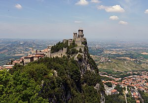
The Cesta, also known as "Fratta" (Italian: Torre della Fratta) is one of three towered peaks overlooking the city of San Marino, the capital of San Marino. The other two are Guaita and Montale.

Guaita
Distance: Approx. 236 meters
Latitude and longitude: 43.9354,12.4496
The Guaita, also known as the Rocca (Italian: "La Rocca") is one of three towered peaks overlooking the city of San Marino, the capital of San Marino. The other two are Cesta and Montale.

Montale (San Marino)
Distance: Approx. 413 meters
Latitude and longitude: 43.9301,12.4526
The Montale is one of three towered peaks overlooking the city of San Marino, the capital of San Marino. The other two are the Guaita and the Cesta.

Three Towers of San Marino
Group of towers located in San Marino
Distance: Approx. 189 meters
Latitude and longitude: 43.935,12.45
The Three Towers of San Marino are a group of towers located in San Marino. Located on the three peaks of Monte Titano in the capital, also called San Marino, they are depicted on both the national flag and coat of arms.

Sammarinese Museum of Ancient Arms
Military in San Marino
Distance: Approx. 140 meters
Latitude and longitude: 43.933,12.4517
Sammarinese Museum of Ancient Arms (Museo delle armi antiche di San Marino in Italian) is located in the Cesta, the second tower of San Marino. The museum opened in 1956 due to agreement with Sammarinese collector Giovanni Carlo Giorgetti. Exhibition, divided to four rooms, contains about 2000 ancient arms and armours.

San Francesco, San Marino
Church in San Marino
Distance: Approx. 322 meters
Latitude and longitude: 43.9353,12.4471
Chiesa di San Francesco is a church in San Marino. It belongs to the Roman Catholic Diocese of San Marino-Montefeltro. It was built in 1361.
Canepa, San Marino
Curazia of the City of San Marino, San Marino
Distance: Approx. 166 meters
Latitude and longitude: 43.9322,12.4486
Canepa is a curazia of San Marino, in the castello of the City of San Marino.

Statua della Libertà
Distance: Approx. 444 meters
Latitude and longitude: 43.9366,12.4469
Statua della Libertà (Italian pronunciation: [ˈstaːtwa della liberˈta; ˈstaːtu.a]) is a statue in Piazza della Libertà, City of San Marino, the capital city of the Republic of San Marino. Translated this means "Statue of Liberty", not to be confused with the statue in New York City, United States. The Statua della Libertà, made in the neoclassical style of white Carrara marble and is located between Parva Domus and the Palazzo Pubblico.
Teatro Titano
Distance: Approx. 242 meters
Latitude and longitude: 43.934603,12.447582
The Teatro Titano is a theatre located in the City of San Marino. It was built in 1750 and was renovated in 1936. The theatre has a capacity of 315 seats.

Torture Museum (San Marino)
Museum in the City of San Marino, San Marino
Distance: Approx. 322 meters
Latitude and longitude: 43.93519444,12.44697222
The Torture Museum (Italian: Museo Della Tortura) is a museum in the City of San Marino, San Marino.
Weather in this IP's area
few clouds
0 Celsius
-4 Celsius
-1 Celsius
3 Celsius
1019 hPa
81 %
1019 hPa
985 hPa
10000 meters
3.6 m/s
310 degree
20 %