Country:
Region:
City:
Latitude and Longitude:
Time Zone:
Postal Code:
IP information under different IP Channel
ip-api
Country
Region
City
ASN
Time Zone
ISP
Blacklist
Proxy
Latitude
Longitude
Postal
Route
Luminati
Country
ASN
Time Zone
Europe/Paris
ISP
Outscale SASU
Latitude
Longitude
Postal
IPinfo
Country
Region
City
ASN
Time Zone
ISP
Blacklist
Proxy
Latitude
Longitude
Postal
Route
db-ip
Country
Region
City
ASN
Time Zone
ISP
Blacklist
Proxy
Latitude
Longitude
Postal
Route
ipdata
Country
Region
City
ASN
Time Zone
ISP
Blacklist
Proxy
Latitude
Longitude
Postal
Route
Popular places and events near this IP address
Saint-Cloud
Commune in Île-de-France, France
Distance: Approx. 79 meters
Latitude and longitude: 48.84,2.22
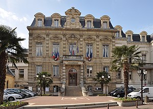
Saint-Cloud (French pronunciation: [sɛ̃ klu]) is a commune in the western suburbs of Paris, France, 9.6 kilometres (6.0 miles) from the centre of Paris. Like other communes of Hauts-de-Seine such as Marnes-la-Coquette, Neuilly-sur-Seine and Vaucresson, Saint-Cloud is one of France's wealthiest towns, with the second-highest average household income of communities with 10,000 to 50,000 households. Saint-Cloud is home to the International Bureau of Weights and Measures (IBWM), located in the Parc de Saint-Cloud's Pavillon de Breteuil.

Boulogne–Pont de Saint-Cloud station
Metro station in Paris, France
Distance: Approx. 623 meters
Latitude and longitude: 48.840684,2.228331
Boulogne–Pont de Saint-Cloud (French pronunciation: [bulɔɲ pɔ̃ də sɛ̃ klu]) is the western terminus of Line 10 of the Paris Métro. The station lies under the Rond-Point Rhin et Danube, near the Pont de Saint-Cloud bridge over the Seine, in the commune of Boulogne-Billancourt. The station was opened on 2 October 1981 when Line 10 was extended from Boulogne–Jean Jaurès.

Château de Saint-Cloud
Former royal palace in France, today a national park
Distance: Approx. 517 meters
Latitude and longitude: 48.8375,2.21472222
The Château de Saint-Cloud (French pronunciation: [ʃato d(ə) sɛ̃ klu]) was a château in France, built on a site overlooking the Seine at Saint-Cloud in Hauts-de-Seine, about 5 kilometres (3 miles) west of Paris. On the site of the former palace is the state-owned Parc de Saint-Cloud. The château was expanded by Philippe I, Duke of Orléans in the 17th century, and by Marie Antoinette in the 1780s.
Île-de-France tramway Line 2
Tram line in Paris, Hauts-de-Seine and Val-d'Oise
Distance: Approx. 307 meters
Latitude and longitude: 48.8431,2.2219
Île-de-France tramway Line 2 (T2; French: Ligne 2 du tramway d'Île-de-France) is part of the modern tram network of the Île-de-France region of France. It connects the commune of Bezons in the north to the Porte de Versailles Métro station in Paris in the south, serving Hauts-de-Seine and its La Défense business district. The line has been operated by the RATP Group since its opening, under the authority of Île-de-France Mobilités.

Parc de Saint-Cloud
French national estate in Greater Paris
Distance: Approx. 517 meters
Latitude and longitude: 48.8375,2.21472222
The Parc de Saint-Cloud (pronounced [paʁk də sɛ̃ klu]; Park of Saint-Cloud), officially the Domaine national de Saint-Cloud (pronounced [dɔmɛn nɑsjɔnal də sɛ̃ klu]; National Estate of Saint-Cloud), is a domaine national (national estate) located mostly within the Saint-Cloud commune, in the Hauts-de-Seine department, southwest of Paris, France. The park, which covers 460 hectares (1,100 acres), was a nature reserve on the left bank of the Seine until 1923. It was centred around the former Château de Saint-Cloud, home of Philippe I, Duke of Orléans (1640–1701), which was destroyed by French bombing in 1870 during the Franco-Prussian War after the Prussians had made a base of it.
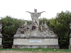
France Crowning Art and Industry
Distance: Approx. 627 meters
Latitude and longitude: 48.83507,2.21987
France Crowning Art and Industry (French: La France couronnant l'Art et l'Industrie) is a 6.50 m (21 ft) tall limestone sculpture group which decorated the top of the entrance of Palais de l'Industrie, the main building of the 1855 international exhibition in Paris. It was moved to the park of Saint-Cloud in 1900 when the Palais de l'Industrie was demolished. The center group, composed of the three allegories (France, Art and Industry) is a work by sculptor Élias Robert.
Pont de Saint-Cloud
Bridge in France
Distance: Approx. 281 meters
Latitude and longitude: 48.84111111,2.22361111
The Pont de Saint-Cloud (Bridge of Saint-Cloud) is a metal bridge which crosses the Seine between the communes of Boulogne-Billancourt and Saint-Cloud in the department of Hauts-de-Seine just west of Paris, France. The first Pont de Saint-Cloud appeared in 841 because of a conflict between Charles the Bald et Lothaire I; it consisted of a wooden bridge supporting several mills. Although the Seine has been traversable at this location for twelve centuries, tradition holds that no king of France has traversed it on the bridge without suffering a sudden death.

Musée Albert-Kahn
Museum in France
Distance: Approx. 594 meters
Latitude and longitude: 48.8417,2.2278
The Musée Albert-Kahn is a departmental museum in Boulogne-Billancourt, France, at 14, rue du Port, including four hectares of gardens, joining landscape scenes of various national traditions. The museum includes historical photographs and films collected by the banker and philanthropist Albert Kahn. Since September 2014, construction works are committed for the extension and the refurbishment of the museum supervised by the architect Kengo Kuma with the cooperation of Ducks Scéno for the construction of another gallery of the exhibition and the renovation of the existing buildings, allowing access to the public in a permanent route.

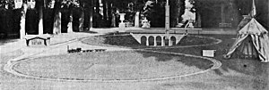
Railway of the Prince Imperial
First documented model railway
Distance: Approx. 619 meters
Latitude and longitude: 48.8371,2.2134
The railway of the Prince Imperial (French: Chemin de fer du Prince impérial) was the first documented model railway in the world.
Groupe Scolaire Maïmonide Rambam
Private, Jewish school in Boulogne-Billancourt, France
Distance: Approx. 705 meters
Latitude and longitude: 48.843,2.2288
Groupe Scolaire Maïmonide Rambam, named for the medieval philosopher Maimonides, is a Jewish private school in Boulogne-Billancourt, France, in the Paris metropolitan area. It serves levels maternelle (preschool) until lycée (senior high school). It was established as Ecole Maïmonide in 1935.
Canton of Saint-Cloud
Administrative division of Hauts-de-Seine, France
Distance: Approx. 724 meters
Latitude and longitude: 48.84,2.21
The canton of Saint-Cloud is an administrative division of the Hauts-de-Seine department in northern France. Its borders were modified at the French canton reorganisation which came into effect in March 2015. Its seat is in Saint-Cloud.
René Huguenin Hospital
Hospital in Île-de-France, France
Distance: Approx. 481 meters
Latitude and longitude: 48.8447941,2.217725
The René Huguenin Hospital is a renowned teaching hospital in Saint-Cloud, France. Part of the Curie Institute and a teaching hospital of Versailles Saint-Quentin-en-Yvelines University. Established in 2010, it was named in honour of René Huguenin (1894–1955), oncologist, Professor of Pathology and a former director of the Institut Gustave Roussy.
Weather in this IP's area
mist
7 Celsius
5 Celsius
6 Celsius
8 Celsius
1025 hPa
98 %
1025 hPa
1020 hPa
4300 meters
3.09 m/s
70 degree
100 %
07:49:34
17:20:16


