Country:
 Poland
Region:
City:
Latitude and Longitude:
Time Zone:
Postal Code:
IP information under different IP Channel
ip-api
Country
Region
City
ASN
Time Zone
ISP
Blacklist
Proxy
Latitude
Longitude
Postal
Route
IPinfo
Country
Region
City
ASN
Time Zone
ISP
Blacklist
Proxy
Latitude
Longitude
Postal
Route
MaxMind
Country
Region
City
ASN
Time Zone
ISP
Blacklist
Proxy
Latitude
Longitude
Postal
Route
Luminati
Country
PLRegion
20
City
bialystok
ASN
Time Zone
Europe/Warsaw
ISP
KOBA Sp. z o.o.
Latitude
Longitude
Postal
db-ip
Country
Region
City
ASN
Time Zone
ISP
Blacklist
Proxy
Latitude
Longitude
Postal
Route
ipdata
Country
Region
City
ASN
Time Zone
ISP
Blacklist
Proxy
Latitude
Longitude
Postal
Route
Popular places and events near this IP address

Osiedle Centrum, Białystok
District of Białystok in Podlaskie Voivodeship, Poland
Distance: Approx. 327 meters
Latitude and longitude: 53.13277778,23.15527778
Osiedle Centrum is the oldest, central, representative district of the Polish city of Białystok.

Belastok Region
Distance: Approx. 364 meters
Latitude and longitude: 53.13333333,23.15
Belastok Region, also known as Belastok Voblasts or Belostok Oblast (Belarusian: Беластоцкая вобласць, romanized: Biełastockaja vobłasć; Russian: Белостокская область; Polish: Obwód białostocki) was a short-lived region (voblasts) of the Byelorussian SSR during World War II, lasting from September 1939 until Operation Barbarossa in 1941, and again for a short period in 1944. The administrative center of the region was the city of Białystok (Belastok), which was annexed from Poland in 1939.

Great Synagogue (Białystok)
Destroyed synagogue in Białystok, Poland
Distance: Approx. 323 meters
Latitude and longitude: 53.13055556,23.15722222
The Great Synagogue (Polish: Wielka Synagoga w Białymstoku) was a former Orthodox Jewish congregation and synagogue, that was located in Białystok, in Podlaskie Voivodeship, Poland. The synagogue building was designed by Szlojme Rabinowicz and completed in 1913. The building served as a house of prayer until World War II when it was destroyed by Nazis on June 27, 1941.

Belostok Oblast
1807–1842 unit of Russia
Distance: Approx. 364 meters
Latitude and longitude: 53.13333333,23.15
Belostok Oblast (Russian: Белостокская область; Polish: Obwód białostocki) was an administrative-territorial unit (oblast) of the Russian Empire with its capital in Belostok (Białystok).
Bialystok District
Nazi German administrative unit in occupied Eastern Poland
Distance: Approx. 364 meters
Latitude and longitude: 53.13333333,23.15
Bialystok District (German: Bezirk Bialystok) was an administrative unit of Nazi Germany created during the World War II invasion of the Soviet Union. It was to the south-east of East Prussia, in present-day northeastern Poland as well as in smaller sections of adjacent present-day Belarus and Lithuania. It was sometimes also referred to by the designation South East Prussia (German: Südostpreußen - see the map below) along with the Regierungsbezirk Zichenau, although in contrast to the latter, it was not incorporated into, but merely attached to East Prussia.
Białystok Department
Distance: Approx. 364 meters
Latitude and longitude: 53.13333333,23.15
The Białystok Department (‹See Tfd›German: Kammerdepartement Bialystok, Polish: Departament białostocki) was part of the New East Prussia Province of the Kingdom of Prussia from 1795 to 1807. It was created out of territory annexed in the Third Partition of Poland and included parts of Podlaskie.

Nomer Tamid Synagogue
Destroyed synagogue in Białystok, Poland
Distance: Approx. 342 meters
Latitude and longitude: 53.1307,23.1575
The Nomer Tamid Synagogue (Polish: Synagoga Nomer Tamid w Białymstoku; Hebrew: בית כנסת נומר תמיד, lit. 'Synagogue of the Eternal Flame'), also known as the Nomer Tamid Beth Midrash or Ner Tamid Beth Midrasz, was a former Orthodox Jewish congregation and wooden synagogue, that was located in Białystok, in the Podlaskie Voivodeship of Poland. Completed in 1703 or 1711, the synagogue served as a house of prayer until World War II when it was destroyed by Nazis in 1939. Funding for the building was provided by Jan Klemens Branicki.

Piaskower Synagoge
Former synagogue in Białystok, Poland
Distance: Approx. 179 meters
Latitude and longitude: 53.129111,23.154
The Piaskower Synagogue (Polish: Synagoga Piaskower) is a former Orthodox Jewish congregation and synagogue, located at 3 Piękna Street, in the Piaski district of Białystok, in the Podlaskie Voivodeship of Poland. Completed in 1893, the former synagogue served as a place of worship until desecrated by Nazis during World War II. After the war, the former synagogue served as a community center for Jews living in Białystok until 1968, and following a fire in 1989, the building has been used for profane purposes since 1995.
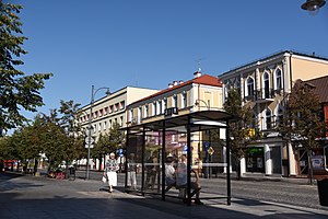
Lipowa Street, Białystok
Street in Białystok, Poland
Distance: Approx. 312 meters
Latitude and longitude: 53.13305556,23.15388889
Lipowa Street is a representative street at the center of Białystok, Poland, running from the Kościuszko Square (corner of Spółdzielcza Street) to Romana Dmowskiego Niepodległości Square (corner of Krakowska street). The street is made up of low buildings mostly of 2-3 floors with various shops, offices and restaurants located at the ground floor.

Podlaska Opera and Orchestra
Opera house in Białystok, Poland
Distance: Approx. 194 meters
Latitude and longitude: 53.12972222,23.14972222
Podlaska Opera and Orchestra in Białystok (Polish: Opera i Filharmonia Podlaska – Europejskie Centrum Sztuki im. Stanisława Moniuszki w Białymstoku) is a cultural institution in Białystok, capital of Podlaskie Voivodeship of Poland. It is the largest artistic institution in north-eastern Poland and the most modern cultural center in this part of Europe.
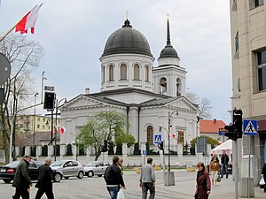
Orthodox Cathedral of St. Nicholas, Białystok
Church in Centrum District, Białystok
Distance: Approx. 298 meters
Latitude and longitude: 53.13274167,23.15454722
The Orthodox Cathedral of St. Nicholas in Białystok (Polish: Sobór św. Mikołaja Cudotwórcy; Russian: Николаевский собор) is an historic Orthodox cathedral in Bialystok, Poland St.

Orthodox Church of St. Mary Magdalene in Białystok
Church in Centrum District, Białystok
Distance: Approx. 282 meters
Latitude and longitude: 53.12972222,23.14833333
Orthodox Church of St. Mary Magdalene in Białystok (Polish: Cerkiew św. Marii Magdaleny w Białymstoku) is an orthodox church in Białystok.
Weather in this IP's area
overcast clouds
9 Celsius
8 Celsius
8 Celsius
9 Celsius
1025 hPa
60 %
1025 hPa
1007 hPa
10000 meters
1.79 m/s
4.47 m/s
31 degree
100 %
06:27:23
18:07:04