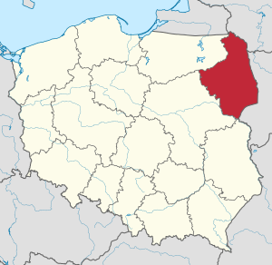
Country:
 Poland
Region:
City:
Latitude and Longitude:
Time Zone:
Postal Code:
IP information under different IP Channel
ip-api
Country
Region
City
ASN
Time Zone
ISP
Blacklist
Proxy
Latitude
Longitude
Postal
Route
IPinfo
Country
Region
City
ASN
Time Zone
ISP
Blacklist
Proxy
Latitude
Longitude
Postal
Route
MaxMind
Country
Region
City
ASN
Time Zone
ISP
Blacklist
Proxy
Latitude
Longitude
Postal
Route
Luminati
Country
PLRegion
20
City
bialystok
ASN
Time Zone
Europe/Warsaw
ISP
KOBA Sp. z o.o.
Latitude
Longitude
Postal
db-ip
Country
Region
City
ASN
Time Zone
ISP
Blacklist
Proxy
Latitude
Longitude
Postal
Route
ipdata
Country
Region
City
ASN
Time Zone
ISP
Blacklist
Proxy
Latitude
Longitude
Postal
Route
Popular places and events near this IP address

Medical University of Białystok
Public university in Białystok, Poland
Distance: Approx. 1492 meters
Latitude and longitude: 53.13027778,23.16583333
The Medical University of Białystok (UMB; Polish: Uniwersytet Medyczny w Białymstoku) is a medical university located in Białystok, the capital of Podlaskie Voivodeship in northeastern Poland. The university is home to the Medical Department with a Division of Dentistry and a six-year M.D. program taught in English (English Division), Pharmacology Department with Medical Analytics Division, and a Nursing and Health Protection Department with divisions in Physiotherapy, Medical Rescue, Obstetrics, Public Health and Nursing.

Osiedle Bojary, Białystok
District of Białystok in Podlaskie Voivodeship, Poland
Distance: Approx. 1431 meters
Latitude and longitude: 53.13472222,23.17555556
Bojary is one of the districts of the Polish city of Białystok.

Osiedle Piasta I, Białystok
District of Białystok in Podlaskie Voivodeship, Poland
Distance: Approx. 1277 meters
Latitude and longitude: 53.133333,23.193333
Osiedle Piasta I is one of the districts of the Polish city of Białystok. Named after the royal Piast dynasty.

Osiedle Piasta II, Białystok
District of Białystok in Podlaskie Voivodeship, Poland
Distance: Approx. 686 meters
Latitude and longitude: 53.128981,23.181624
Osiedle Piasta II is one of the districts of the Polish city of Białystok. Named after the royal Piast dynasty. District with the smallest area in Bialystok.

Osiedle Mickiewicza, Białystok
Osiedle (city district) in Białystok, Poland
Distance: Approx. 736 meters
Latitude and longitude: 53.120891,23.174318
Osiedle Mickiewicza is one of the districts in the Polish city of Białystok. It is located in the south-central part of the city and is named after poet Adam Mickiewicz.

Białystok County
County in Podlaskie Voivodeship, Poland
Distance: Approx. 1402 meters
Latitude and longitude: 53.11666667,23.16666667
Białystok County (Polish: powiat białostocki) is a unit of territorial administration and local government (powiat) in Podlaskie Voivodeship, north-eastern Poland, on the border with Belarus. It was created on 1 January 1999 as a result of the Polish local government reforms passed in 1998. Its administrative seat is the city of Białystok, although the city is not part of the county (it constitutes a separate city county).
Podlaskie Voivodeship
Voivodeship of Poland
Distance: Approx. 1402 meters
Latitude and longitude: 53.11666667,23.16666667
Podlaskie Voivodeship (Polish: Województwo podlaskie [vɔjɛˈvut͡stfɔ pɔˈdlaskʲɛ] ) is a voivodeship (province) in northeastern Poland. The name of the province refers to the historical region of Podlachia (in Polish, Podlasie), and part of its territory corresponds to that region. The capital and largest city is Białystok.

Aleksandr Węgierki Drama Theatre, Białystok
Theatre in Białystok, Poland
Distance: Approx. 1275 meters
Latitude and longitude: 53.12986389,23.16929722
The Aleksander Węgierko Drama Theatre in Białystok (Polish: Teatr Dramatyczny im. Aleksandra Węgierki w Białymstoku) is a repertory theatre in Białystok, established in 1938. It was founded by actor Aleksander Węgierko.
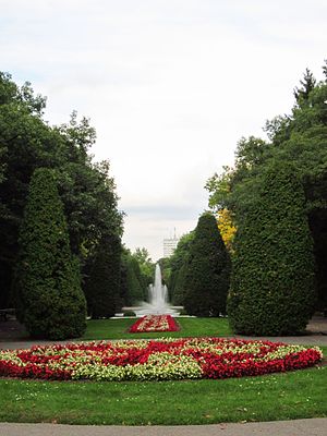
Planty Park (Białystok)
Park in Białystok, Poland
Distance: Approx. 1273 meters
Latitude and longitude: 53.127025,23.16680556
Planty Park is a city park in Białystok, capital of Podlaskie Voivodeship, with an area of 14.94 ha. It connects the Constitution of 3 May Park with the Poniatowski Park.

Voivodeship Hospital in Białystok
Hospital in Podlaskie Voivodeship, Poland
Distance: Approx. 1442 meters
Latitude and longitude: 53.12548318,23.16347989
Śniadeckiego Voivodeship Hospital in Bialystok (Polish: Samodzielny Publiczny Zakład Opieki Zdrowotnej Wojewódzki Szpital Zespolony im. J. Śniadeckiego w Białymstoku) is a general hospital in Białystok capital of Podlaskie Voivodeship in north-east Poland. It is under the jurisdiction of the Podlaskie Voivodeship Marshal's Office and is located in a complex of buildings in Skłodowskiej Street.

Józef Poniatowski Park in Białystok
Park in Białystok, Poland
Distance: Approx. 1321 meters
Latitude and longitude: 53.13,23.16861111
Old Park named after Prince Józef Poniatowski (Polish: Park Stary im. księcia Józefa Poniatowskiego) a naturalistic park in Białystok with modernist elements located in the Centrum District of Białystok, capital of Podlaskie Voivodeship. Established in the years 1895–1897 on the site of a former mill pond on the Biała River, part of the composition of the palace gardens with an area of 4.76 ha in Białystok, it was designed by Walerian Kronenberg in cooperation with Teodor Chrząński.

Constitution of 3 May Park (Białystok)
Distance: Approx. 1437 meters
Latitude and longitude: 53.12055556,23.16361111
Constitution of 3 May Park (Polish: Park Konstytucji 3 Maja w Białymstoku) is a park in Piaski District in Białystok, Podlaskie Voivodeship
Weather in this IP's area
overcast clouds
9 Celsius
8 Celsius
8 Celsius
9 Celsius
1025 hPa
61 %
1025 hPa
1009 hPa
10000 meters
1.79 m/s
4.47 m/s
33 degree
100 %
06:27:15
18:06:57