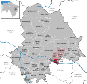
109.230.230.150 - IP Lookup: Free IP Address Lookup, Postal Code Lookup, IP Location Lookup, IP ASN, Public IP
Country:
Region:
City:
Location:
Time Zone:
Postal Code:
IP information under different IP Channel
ip-api
Country
Region
City
ASN
Time Zone
ISP
Blacklist
Proxy
Latitude
Longitude
Postal
Route
Luminati
Country
ASN
Time Zone
Europe/Berlin
ISP
active 1 GmbH
Latitude
Longitude
Postal
IPinfo
Country
Region
City
ASN
Time Zone
ISP
Blacklist
Proxy
Latitude
Longitude
Postal
Route
IP2Location
109.230.230.150Country
Region
niedersachsen
City
weyhausen
Time Zone
Europe/Berlin
ISP
Language
User-Agent
Latitude
Longitude
Postal
db-ip
Country
Region
City
ASN
Time Zone
ISP
Blacklist
Proxy
Latitude
Longitude
Postal
Route
ipdata
Country
Region
City
ASN
Time Zone
ISP
Blacklist
Proxy
Latitude
Longitude
Postal
Route
Popular places and events near this IP address

Fallersleben
Ortsteil of Wolfsburg in Lower Saxony, Germany
Distance: Approx. 4810 meters
Latitude and longitude: 52.41888889,10.71694444
Fallersleben is a part (Ortsteil) of the City of Wolfsburg, Lower Saxony, Germany, with a population of 11,269 (as of 2010). The village of Fallersleben was first mentioned in 942 under the name of Valareslebo. Fallersleben became a city in 1929, and was incorporated into Wolfsburg in 1972.

Boldecker Land
Samtgemeinde in Lower Saxony, Germany
Distance: Approx. 509 meters
Latitude and longitude: 52.46666667,10.71666667
Boldecker Land is a municipality in the district of Gifhorn, in Lower Saxony, Germany. It is situated along the river Aller, approx. 12 km east of Gifhorn, and 8 km northwest of Wolfsburg.

Arbeitsdorf concentration camp
Nazi concentration camp
Distance: Approx. 4649 meters
Latitude and longitude: 52.43333333,10.76666667
Arbeitsdorf ("work-village") was a Nazi concentration camp in Stadt des KdF-Wagens bei Fallersleben 1942.

Bokensdorf
Municipality in Lower Saxony, Germany
Distance: Approx. 3975 meters
Latitude and longitude: 52.49777778,10.71444444
Bokensdorf is a municipality in the district of Gifhorn, in Lower Saxony, Germany.

Jembke
Municipality in Lower Saxony, Germany
Distance: Approx. 4877 meters
Latitude and longitude: 52.49722222,10.76
Jembke is a municipality in the district of Gifhorn, in Lower Saxony, Germany.

Osloß
Municipality in Lower Saxony, Germany
Distance: Approx. 2339 meters
Latitude and longitude: 52.46666667,10.68333333
Osloß is a municipality in the district of Gifhorn, in Lower Saxony, Germany.

Tappenbeck
Municipality in Lower Saxony, Germany
Distance: Approx. 2295 meters
Latitude and longitude: 52.46666667,10.75
Tappenbeck is a municipality in the district of Gifhorn, in Lower Saxony, Germany.

Weyhausen
Municipality in Lower Saxony, Germany
Distance: Approx. 509 meters
Latitude and longitude: 52.46666667,10.71666667
Weyhausen is a municipality in the district of Gifhorn, in Lower Saxony, Germany.

Barnbruch
Wetland in Lower Saxony, Germany
Distance: Approx. 4412 meters
Latitude and longitude: 52.45643,10.65262
The Barnbruch is a wetland of international importance in the old glacial valley of the river Aller that provides a habitat for endangered species of birds, amphibians and insects. It lies between the city of Wolfsburg and town of Gifhorn and consists of an enclosed woodland area of around 1,500 hectares (3,700 acres) with surrounding meadows and pastures. This low-lying depression lies partly within the territory of the city of Wolfsburg and partly within Gifhorn district.

Kleine Aller
River in Germany
Distance: Approx. 1548 meters
Latitude and longitude: 52.4508,10.7303
The Kleine Aller is a tributary of the Aller in the German state of Lower Saxony. It is about 23 kilometres (14 mi) long and up to 5 metres (16 ft) wide, and flows from north to south through the district of Gifhorn and the city of Wolfsburg.

Fallersleben Castle
Castle in Wolfsburg, Germany
Distance: Approx. 5010 meters
Latitude and longitude: 52.41709167,10.71649444
Fallersleben Castle (German: Schloss Fallersleben) is located in Wolfsburg in the German state of Lower Saxony and, together with Neuhaus and Wolfsburg Castles, is one of the most important historic buildings in the town. It is in the district of Fallersleben and forms an historic setting along with the castle lake, St. Michael's Church and the Old Brewery.

Fallersleben station
Railway station in Wolfsburg, Germany
Distance: Approx. 4313 meters
Latitude and longitude: 52.42336,10.717322
Fallersleben (German: Bahnhof Fallersleben) is a railway station located in Wolfsburg, Germany. The station is located on the Berlin-Lehrte Railway. The train services are operated by Metronom.
Weather in this IP's area
overcast clouds
3 Celsius
-1 Celsius
2 Celsius
5 Celsius
1027 hPa
89 %
1027 hPa
1020 hPa
10000 meters
4.63 m/s
230 degree
100 %