Country:
 Germany
Region:
City:
Latitude and Longitude:
Time Zone:
Postal Code:
IP information under different IP Channel
ip-api
Country
Region
City
ASN
Time Zone
ISP
Blacklist
Proxy
Latitude
Longitude
Postal
Route
IPinfo
Country
Region
City
ASN
Time Zone
ISP
Blacklist
Proxy
Latitude
Longitude
Postal
Route
MaxMind
Country
Region
City
ASN
Time Zone
ISP
Blacklist
Proxy
Latitude
Longitude
Postal
Route
Luminati
Country
DEASN
Time Zone
Europe/Berlin
ISP
active 1 GmbH
Latitude
Longitude
Postal
db-ip
Country
Region
City
ASN
Time Zone
ISP
Blacklist
Proxy
Latitude
Longitude
Postal
Route
ipdata
Country
Region
City
ASN
Time Zone
ISP
Blacklist
Proxy
Latitude
Longitude
Postal
Route
Popular places and events near this IP address

Burg Teck
Ducal castle in the kingdom of Württemberg
Distance: Approx. 1778 meters
Latitude and longitude: 48.58805556,9.47055556
Teck Castle (German: Burg Teck) was a ducal castle in the kingdom of Württemberg, immediately to the north of the Swabian Jura and south of the town of Kirchheim unter Teck (now in the district of Esslingen). The castle took its name from the Teckberg ridge, 2,544 feet (775 m) high, which it crowned. It was destroyed in the German Peasants' War (1525).
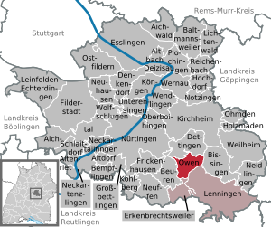
Owen, Germany
Town in Baden-Württemberg, Germany
Distance: Approx. 3041 meters
Latitude and longitude: 48.58833333,9.45138889
Owen (German pronunciation: [ˈaʊ.ən], see below) is a town in the district of Esslingen in Baden-Württemberg in southern Germany. It is located 40 kilometres (25 mi) southeast of Stuttgart and 7 kilometres (4.3 mi) south of Kirchheim unter Teck.

Bissingen an der Teck
Municipality in Baden-Württemberg, Germany
Distance: Approx. 307 meters
Latitude and longitude: 48.59944444,9.4925
Bissingen (Swabian: Bissenge) is a municipality in the district of Esslingen in Baden-Württemberg in southern Germany.

Dettingen unter Teck
Municipality in Baden-Württemberg, Germany
Distance: Approx. 3567 meters
Latitude and longitude: 48.61611111,9.45166667
Dettingen is a municipality in the district of Esslingen in Baden-Württemberg in southern Germany.

Breitenstein (Swabian Jura)
Distance: Approx. 1745 meters
Latitude and longitude: 48.58305556,9.50138889
Breitenstein is a mountain of Baden-Württemberg, Germany. The Breitenstein is an 811.6 m above sea level. NHN [1] high plateau in Baden-Württemberg.

Hohenbol
Distance: Approx. 1790 meters
Latitude and longitude: 48.6,9.46666667
The Hohenbol is a mountain of Baden-Württemberg, Germany. Hohenbol (Baden-Württemberg) Type Witnesses Mountain of volcanic origin The Hohenbol is a 602.1 m above sea level (NHN) high mountain 2 kilometers from the town of Owen in the district of Esslingen in Baden-Württemberg. The Hohenbol is a foothill of the Teckberg and upstrimes this northwest.

Limburg (Weilheim an der Teck)
Distance: Approx. 3467 meters
Latitude and longitude: 48.60416667,9.53638889
Limburg (Weilheim an der Teck) is a mountain of Baden-Württemberg, Germany. Striking is the breakdown of vegetation: the summit is covered with lean lawn and some solitary Tilia. Below this is a zone of scrub forest on the southern slope with vineyards, and on the lower slopes of extensive orchards.

Teckberg
Distance: Approx. 1778 meters
Latitude and longitude: 48.58805556,9.47055556
Teckberg is a mountain located in Landkreis Esslingen, Baden-Württemberg, Germany. It stands at an elevation of 775 m above sea level (NHN) (2,543 ft) and is crowned by the castle Teck.

Burgruine Diepoldsburg
Ruined castle in Germany
Distance: Approx. 2731 meters
Latitude and longitude: 48.5725,9.48861111
Ruine Diepoldsburg is a ruined castle nearby the community of Lenningen, Baden-Württemberg, Germany.
Albvorland Tunnel
Distance: Approx. 4023 meters
Latitude and longitude: 48.6298496,9.4677883
The Albvorland Tunnel is a 8,176 m long twin-tube railway tunnel on the Wendlingen–Ulm high-speed railway in Baden-Württemberg. It underpasses a part of the town Kirchheim-Lindorf and Bundesautobahn 8 at the junction of Kirchheim-East in the industrial area of Dettingen unter Teck The tunnel is situated between kilometer 26.077 and 34.253 on the railway line. It is on the boundary of Wendlingen am Neckar, Kirchheim unter Teck, Lindorf and Dettingen unter Teck.
Federbach (Lindach)
River in Germany
Distance: Approx. 3700 meters
Latitude and longitude: 48.6232,9.5215
Federbach is a river of Baden-Württemberg, Germany. It is a left tributary of the Lindach at Weilheim an der Teck.

Randecker Maar
Volcanic crater and nature reserve in Germany
Distance: Approx. 3491 meters
Latitude and longitude: 48.57416667,9.52305556
The Randecker Maar is a maar – a volcanic crater about 1.2 kilometres (0.75 miles) wide. It is in the Swabian Jura mountains, in the municipality Bissingen an der Teck near Stuttgart and was formed around 17 million years ago. A lake formed in the crater and its bed is now a layer of the early Miocene in which many fossils have been found.
Weather in this IP's area
overcast clouds
16 Celsius
15 Celsius
14 Celsius
17 Celsius
1019 hPa
79 %
1019 hPa
969 hPa
10000 meters
1.54 m/s
1.32 m/s
351 degree
100 %
07:48:19
18:25:15