Country:
Region:
City:
Latitude and Longitude:
Time Zone:
Postal Code:
IP information under different IP Channel
ip-api
Country
Region
City
ASN
Time Zone
ISP
Blacklist
Proxy
Latitude
Longitude
Postal
Route
Luminati
Country
Region
46
City
stryi
ASN
Time Zone
Europe/Kyiv
ISP
Teleradiocompany TeleLan LLC
Latitude
Longitude
Postal
IPinfo
Country
Region
City
ASN
Time Zone
ISP
Blacklist
Proxy
Latitude
Longitude
Postal
Route
db-ip
Country
Region
City
ASN
Time Zone
ISP
Blacklist
Proxy
Latitude
Longitude
Postal
Route
ipdata
Country
Region
City
ASN
Time Zone
ISP
Blacklist
Proxy
Latitude
Longitude
Postal
Route
Popular places and events near this IP address

Stryi
City in Lviv Oblast, Ukraine
Distance: Approx. 1924 meters
Latitude and longitude: 49.25,23.85
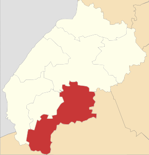
Stryi (Ukrainian: Стрий, IPA: [strɪj] ; Polish: Stryj) is a city in Lviv Oblast, western Ukraine. It is located in the left bank of the Stryi River, approximately 65 kilometres (40 mi) south of Lviv in the foothills of the Carpathian Mountains. It serves as the administrative center of Stryi Raion within the oblast.

Stryi Air Base
Ukrainian air force base
Distance: Approx. 5151 meters
Latitude and longitude: 49.24333333,23.78666667
Stryi (Ukrainian Стрий, also Stryi, or Stryy) was an air base in Lviv Oblast, Ukraine located 4 km southwest of Stryi. It was a large base with 6 km of parking area taxiways and numerous revetments.

Ukrainian Catholic Eparchy of Stryi
Ukrainian Greek Catholic eparchy in Ukraine
Distance: Approx. 1924 meters
Latitude and longitude: 49.25,23.85
The Eparchy of Stryi is an eparchy of the Ukrainian Greek Catholic Church. It is a suffragan see of the Archeparchy of Lviv. The first Eparch was Bishop Julian Gbur, who was appointed to this position by Pope John Paul II on 21 July 2000.

Stryi Raion
Subdivision of Lviv Oblast, Ukraine
Distance: Approx. 4689 meters
Latitude and longitude: 49.22694444,23.86638889
Stryi Raion (Ukrainian: Стрийський район) is a raion (district) in Lviv Oblast in western Ukraine. Its administrative center is Stryi. Population: 319,464 (2022 estimate).
Uhersko, Ukraine
Rural locality in Lviv Oblast, Ukraine
Distance: Approx. 5812 meters
Latitude and longitude: 49.30083333,23.90861111
Uhersko (Ukrainian: Уге́рсько), in 1946–1993 Yablunivka (Ukrainian: Яблунівка) is a village (selo) in Stryi Raion, Lviv Oblast, of Western Ukraine.
Nezhukhiv
Rural locality in Lviv Oblast, Ukraine
Distance: Approx. 4252 meters
Latitude and longitude: 49.27111111,23.78916667
Nezhukhiv (Ukrainian: Нежу́хів) – village (selo), which is located in Stryi Raion, Lviv Oblast, of Western Ukraine. It belongs to Stryi urban hromada, one of the hromadas of Ukraine. Village, which is situated on the way Stryi — Drohobych and lies at a distance 76 kilometres (47 mi) from the city of Lviv, 6 kilometres (3.7 mi) from Stryi and 24 kilometres (15 mi) from Drohobych.
Dobriany, Stryi urban hromada, Stryi Raion, Lviv Oblast
Rural locality in Lviv Oblast, Ukraine
Distance: Approx. 3670 meters
Latitude and longitude: 49.2875,23.88722222
Dobriany (Dobryany, Dobrjany) (Ukrainian: Добря́ни, old name — Дебрин, Добрини) is a village in Stryi Raion, Lviv Oblast in western Ukraine. It belongs to Stryi urban hromada, one of the hromadas of Ukraine. Local government is administered by Dobrianska village council.
Holobutiv
Rural locality in Lviv Oblast, Ukraine
Distance: Approx. 8044 meters
Latitude and longitude: 49.26,23.73722222
Holobutiv (Ukrainian: Голобу́тів) – village (selo) is located in Stryi Raion, Lviv Oblast, of Western Ukraine. It belongs to Stryi urban hromada, one of the hromadas of Ukraine. The population of the village is 937, and the local government is administered by the Holobutivska village council.
Duliby, Hrabovets-Duliby rural hromada, Stryi Raion, Lviv Oblast
Rural locality in Lviv Oblast, Ukraine
Distance: Approx. 4651 meters
Latitude and longitude: 49.23055556,23.81666667
Duliby (Ukrainian: Дулі́би) is a village (selo) located along the Stryi River in Stryi Raion (district) of Lviv Oblast (province) in Western Ukraine. It hosts the administration of Hrabovets-Duliby rural hromada, one of the hromadas of Ukraine. The population of the village is about 3 671 people.

Sokil Stadium (Stryi)
Distance: Approx. 1994 meters
Latitude and longitude: 49.25027778,23.85638889
Stryi City Stadium "Sokil" is a multi-use stadium in Stryi, Ukraine. It is currently used mostly for football matches, and is the home of FC Skala Stryi. The stadium holds 6,000 people.
Stryi urban hromada
Urban hromada in Lviv Oblast, Ukraine
Distance: Approx. 1252 meters
Latitude and longitude: 49.25611111,23.85027778
Stryi urban territorial hromada (Ukrainian: Стрийська міська територіальна громада, romanized: Stryiska miska terytorialna hromada) is an urban hromada (municipality) of Ukraine, located in the western Lviv Oblast. Its administrative centre is the city of Stryi. Stryi urban hromada has a total area of 551.1 square kilometres (212.8 sq mi).
Pishchany
Rural locality in Lviv Oblast, Ukraine
Distance: Approx. 6778 meters
Latitude and longitude: 49.28555556,23.93638889
Pishchany (Ukrainian: Піщани; until Tatarske) is a village in the Stryi urban hromada of the Stryi Raion of Lviv Oblast in Ukraine.
Weather in this IP's area
scattered clouds
4 Celsius
-0 Celsius
4 Celsius
4 Celsius
1012 hPa
68 %
1012 hPa
976 hPa
10000 meters
5.43 m/s
11.47 m/s
241 degree
50 %
07:40:09
16:39:49
