Country:
Region:
City:
Latitude and Longitude:
Time Zone:
Postal Code:
IP information under different IP Channel
ip-api
Country
Region
City
ASN
Time Zone
ISP
Blacklist
Proxy
Latitude
Longitude
Postal
Route
Luminati
Country
ASN
Time Zone
Europe/Paris
ISP
Groupe convergence.com SAS
Latitude
Longitude
Postal
IPinfo
Country
Region
City
ASN
Time Zone
ISP
Blacklist
Proxy
Latitude
Longitude
Postal
Route
db-ip
Country
Region
City
ASN
Time Zone
ISP
Blacklist
Proxy
Latitude
Longitude
Postal
Route
ipdata
Country
Region
City
ASN
Time Zone
ISP
Blacklist
Proxy
Latitude
Longitude
Postal
Route
Popular places and events near this IP address

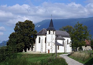
Ayn, Savoie
Commune in Auvergne-Rhône-Alpes, France
Distance: Approx. 3149 meters
Latitude and longitude: 45.5733,5.7514
Ayn (French pronunciation: [ajɛ̃]; Arpitan: Ayin) is a commune in the Savoie department in the Auvergne-Rhône-Alpes region in south-eastern France.

Saint-Alban-de-Montbel
Commune in Auvergne-Rhône-Alpes, France
Distance: Approx. 4736 meters
Latitude and longitude: 45.5525,5.7842
Saint-Alban-de-Montbel (French pronunciation: [sɛ̃.t‿albɑ̃ də mɔ̃bɛl]) is a commune in the Savoie department in the Auvergne-Rhône-Alpes region in south-eastern France.

Saint-Pierre-d'Alvey
Commune in Auvergne-Rhône-Alpes, France
Distance: Approx. 4819 meters
Latitude and longitude: 45.6308,5.7433
Saint-Pierre-d'Alvey (French pronunciation: [sɛ̃ pjɛʁ dalvɛ]; Arpitan: San Pyérè) is a commune in the Savoie department in the Auvergne-Rhône-Alpes region in south-eastern France.
Sainte-Marie-d'Alvey
Commune in Auvergne-Rhône-Alpes, France
Distance: Approx. 4384 meters
Latitude and longitude: 45.5942,5.7214
Sainte-Marie-d'Alvey (French pronunciation: [sɛ̃t maʁi dalvɛ]; Arpitan: Sint Mari) is a commune in the Savoie department in the Auvergne-Rhône-Alpes region in south-eastern France.
Gerbaix
Commune in Auvergne-Rhône-Alpes, France
Distance: Approx. 2916 meters
Latitude and longitude: 45.6106,5.7478
Gerbaix is a commune in the Savoie department in the Auvergne-Rhône-Alpes region in south-eastern France.
Marcieux
Commune in Auvergne-Rhône-Alpes, France
Distance: Approx. 2410 meters
Latitude and longitude: 45.6139,5.7631
Marcieux (French pronunciation: [maʁsjø]; Arpitan: Marcheu) is a commune in the Savoie department in the Auvergne-Rhône-Alpes region in south-eastern France.

Nances
Commune in Auvergne-Rhône-Alpes, France
Distance: Approx. 1599 meters
Latitude and longitude: 45.5911,5.7975
Nances (French pronunciation: [nɑ̃s]; Arpitan: Nanse) is a commune in the Savoie department in the Auvergne-Rhône-Alpes region in south-eastern France.

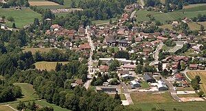
Novalaise
Commune in Auvergne-Rhône-Alpes, France
Distance: Approx. 430 meters
Latitude and longitude: 45.5953,5.7722
Novalaise (French pronunciation: [nɔvalɛz]; Arpitan: Novalaze) is a commune in the Savoie department in the Auvergne-Rhône-Alpes region in south-eastern France.

Rochefort, Savoie
Commune in Auvergne-Rhône-Alpes, France
Distance: Approx. 4468 meters
Latitude and longitude: 45.5831,5.7228
Rochefort (French pronunciation: [ʁɔʃfɔʁ] ; Arpitan: Roshfô) is a commune in the Savoie department in the Auvergne-Rhône-Alpes region in south-eastern France.

Verthemex
Commune in Auvergne-Rhône-Alpes, France
Distance: Approx. 4034 meters
Latitude and longitude: 45.63,5.79
Verthemex (French pronunciation: [vɛʁtəmɛks]) is a commune in the Savoie department in the Auvergne-Rhône-Alpes region in south-eastern France.

Lac d'Aiguebelette
Lake in Savoie, France
Distance: Approx. 4920 meters
Latitude and longitude: 45.55277778,5.79722222
The Lac d'Aiguebelette (French pronunciation: [lak dɛɡbəlɛt]; Lake of Aiguebelette) is a natural lake north of the Chartreuse Mountains in the French Alps and just west of the Chaîne de l'Épine in the Jura Mountains. It is located within five communes in the Savoie department: Aiguebelette-le-Lac, Lépin-le-Lac, Saint-Alban-de-Montbel, Novalaise and Nances. The lake hosted the 1997 and 2015 World Rowing Championships.

Chaîne de l'Épine
Distance: Approx. 3850 meters
Latitude and longitude: 45.58111111,5.82305556
The Chaîne de l'Épine, in the department of Savoie in southeast France, is a 20-kilometre (12 mi) long ridge of the Jura Mountains that runs north–south along the east side of the Lac d'Aiguebelette, from the Col de l'Épine west of Chambéry as far as the western edge of the Chartreuse Mountains, near the commune of Les Échelles. To the north, the ridge becomes the Mont du Chat ridge along the western shore of the Lac du Bourget. At the southern end, the ridge terminates at the Guiers River.
Weather in this IP's area
mist
7 Celsius
6 Celsius
6 Celsius
9 Celsius
1025 hPa
97 %
1025 hPa
971 hPa
1400 meters
2.06 m/s
60 degree
100 %
07:22:31
17:18:26