Country:
Region:
City:
Latitude and Longitude:
Time Zone:
Postal Code:
IP information under different IP Channel
ip-api
Country
Region
City
ASN
Time Zone
ISP
Blacklist
Proxy
Latitude
Longitude
Postal
Route
Luminati
Country
ASN
Time Zone
Europe/Paris
ISP
Groupe convergence.com SAS
Latitude
Longitude
Postal
IPinfo
Country
Region
City
ASN
Time Zone
ISP
Blacklist
Proxy
Latitude
Longitude
Postal
Route
db-ip
Country
Region
City
ASN
Time Zone
ISP
Blacklist
Proxy
Latitude
Longitude
Postal
Route
ipdata
Country
Region
City
ASN
Time Zone
ISP
Blacklist
Proxy
Latitude
Longitude
Postal
Route
Popular places and events near this IP address

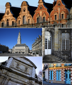
Arras
Prefecture and commune in Hauts-de-France, France
Distance: Approx. 36 meters
Latitude and longitude: 50.292,2.78
Arras ( ARR-əs, French: [aʁɑs] ; Picard: Aros; historical Dutch: Atrecht [ˈaːtrɛxt] ) is the prefecture of the Pas-de-Calais department, which forms part of the region of Hauts-de-France; before the reorganization of 2014 it was in Nord-Pas-de-Calais. The historic centre of the Artois region, with a Baroque town square, Arras is in northern France at the confluence of the rivers Scarpe and Crinchon. The Arras plain is on a large chalk plateau bordered on the north by the Marqueffles fault, on the southwest by the Artois and Ternois hills, and on the south by the slopes of Beaufort-Blavincourt.

Battle of Arras (1654)
1654 clash between the French and the Spanish
Distance: Approx. 280 meters
Latitude and longitude: 50.2897,2.7808
The Battle of Arras, known at that time as the "Secours d'Arras" 'i.e. Arras Aid, fought on 25 August 1654, was a victory of a French army under Turenne against a Spanish army commanded by Don Ferdinand de Salis and the Prince de Condé. The place, held by a French garrison, was besieged by the Spaniards under the Great Condé.
Saint-Nicolas, Pas-de-Calais
Commune in Hauts-de-France, France
Distance: Approx. 1224 meters
Latitude and longitude: 50.3031,2.7781
Saint-Nicolas (French pronunciation: [sɛ̃ nikɔla]; West Flemish: Sint-Niklaas) or Saint-Nicolas-lez-Arras ([sɛ̃ nikɔla lɛ.z‿aʁas], literally Saint-Nicolas near Arras) is a commune in the Pas-de-Calais department in the Hauts-de-France region of France.

Abbey of Saint-Vaast
Abbey in France
Distance: Approx. 503 meters
Latitude and longitude: 50.29194444,2.77333333
The Abbey of St Vaast (French: Abbaye de Saint-Vaast) was a Benedictine monastery situated in Arras, département of Pas-de-Calais, France.

Arras Cathedral
Distance: Approx. 415 meters
Latitude and longitude: 50.29305556,2.77472222
Arras Cathedral (French: Cathédrale Notre-Dame-et-Saint-Vaast d'Arras) is the Catholic church in the city of Arras, France. The cathedral is the seat of the Bishops of Arras.
Canton of Arras-Ouest
Former canton in Hauts-de-France, France
Distance: Approx. 1012 meters
Latitude and longitude: 50.2833,2.7833
The Canton of Arras-Ouest is a former canton situated in the department of the Pas-de-Calais and in the Nord-Pas-de-Calais region of northern France. It was disbanded following the French canton reorganisation which came into effect in March 2015. The canton comprised part of the commune of Arras.
Carrière Wellington
Museum in France
Distance: Approx. 1304 meters
Latitude and longitude: 50.28059983,2.78297983
The Carrière Wellington is a museum in Arras, northern France. It is named after a former underground quarry which was part of a network of tunnels used by forces of the British Empire and Commonwealth during the First World War. Opened in March 2008 (2008-03), the museum commemorates the soldiers who built the tunnels and fought in the Battle of Arras in 1917.

Communauté urbaine d'Arras
Communauté urbaine in Hauts-de-France, France
Distance: Approx. 247 meters
Latitude and longitude: 50.29,2.78
The Communauté urbaine d'Arras is the communauté urbaine, an intercommunal structure, centred on the city of Arras. It is located in the Pas-de-Calais department, in the Hauts-de-France region, northern France. It was created in January 1998, replacing the previous district urbain d'Arras.
Arras station
French railway station
Distance: Approx. 594 meters
Latitude and longitude: 50.2869,2.781391
Arras station (French: Gare d'Arras) is a railway station serving the town Arras, Pas-de-Calais department, northern France. This station, which opened in 1846, is located on the Paris–Lille railway and Arras-Dunkirk railway and accessible from LGV Nord.
Hôtel de Ville, Arras
Town hall in Arras, France
Distance: Approx. 258 meters
Latitude and longitude: 50.2911,2.7772
The Hôtel de Ville (French pronunciation: [otɛl də vil], City Hall) is a historic building in Arras, Pas-de-Calais, northern France, standing at the northwest end of the Place Des Heros in the centre of the town, and its bell-tower representing the main landmark in the town. It was designated a monument historique by the French government in 1921.
Canton of Arras-2
Canton of France
Distance: Approx. 247 meters
Latitude and longitude: 50.29,2.78
The canton of Arras-2 is an administrative division of the Pas-de-Calais department, in northern France. It was created at the French canton reorganisation which came into effect in March 2015. Its seat is in Arras.
2023 Arras school stabbing
2023 Islamist attack in northern France
Distance: Approx. 577 meters
Latitude and longitude: 50.2878,2.7761
On 13 October 2023, a mass stabbing occurred at the Gambetta-Carnot secondary school in Arras, Pas-de-Calais, Hauts-de-France, France. One person was killed, and three others were seriously wounded. The suspect was previously known to the French security services for his involvement with radical Islamism.
Weather in this IP's area
scattered clouds
6 Celsius
4 Celsius
6 Celsius
7 Celsius
1022 hPa
96 %
1022 hPa
1013 hPa
10000 meters
2.49 m/s
2.64 m/s
147 degree
46 %
07:46:28
17:18:29


