Country:
Region:
City:
Latitude and Longitude:
Time Zone:
Postal Code:
IP information under different IP Channel
ip-api
Country
Region
City
ASN
Time Zone
ISP
Blacklist
Proxy
Latitude
Longitude
Postal
Route
Luminati
Country
Region
occ
City
montpellier
ASN
Time Zone
Europe/Paris
ISP
Eurofiber France SAS
Latitude
Longitude
Postal
IPinfo
Country
Region
City
ASN
Time Zone
ISP
Blacklist
Proxy
Latitude
Longitude
Postal
Route
db-ip
Country
Region
City
ASN
Time Zone
ISP
Blacklist
Proxy
Latitude
Longitude
Postal
Route
ipdata
Country
Region
City
ASN
Time Zone
ISP
Blacklist
Proxy
Latitude
Longitude
Postal
Route
Popular places and events near this IP address
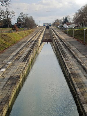
Water slope
Distance: Approx. 5679 meters
Latitude and longitude: 43.33027778,3.20111111
A water slope (French: Pente d'eau) is a type of canal inclined plane built to carry boats from a canal or river at one elevation up or down to a canal or river at another elevation.

Fonseranes Locks
Flight of locks on the Canal du Midi, France
Distance: Approx. 5569 meters
Latitude and longitude: 43.33055556,3.19972222
Fonseranes Locks (French: écluses de Fonseranes, les neuf écluses) are a flight of staircase locks on the Canal du Midi near Béziers. They consist of eight oval-shaped lock chambers, characteristic of the Canal du Midi, and nine gates, which allow boats to be raised a height of 21.5 metres (71 ft) over a distance of 300 metres (980 ft). The flight was originally built as an eight-rise, which together with the ninth lock (the écluse de Notre-Dame, 710 metres (0.44 mi) to the northeast) allowed boats to cross the Orb river on a level and re-enter the canal further downstream.

Béziers Cathedral
Distance: Approx. 5740 meters
Latitude and longitude: 43.34138889,3.21
Béziers Cathedral (French: Cathédrale Saint-Nazaire-et-Saint-Celse de Béziers) is a Roman Catholic church located in Béziers, France. The edifice dates from the thirteenth century, having been erected on the site of an earlier building that was destroyed during the Massacre at Béziers in the Albigensian Crusade. The cathedral was formerly the seat of the Bishopric of Béziers, which was dissolved by the Concordat of 1801 and annexed into the Diocese of Montpellier.

Colombiers, Hérault
Commune in Occitania, France
Distance: Approx. 5079 meters
Latitude and longitude: 43.3139,3.1414
Colombiers (French pronunciation: [kɔlɔ̃bje] ; Occitan: Colombièrs) is a commune in the Hérault department in southern France.

Cazouls-lès-Béziers
Commune in Occitania, France
Distance: Approx. 5038 meters
Latitude and longitude: 43.3933,3.1022
Cazouls-lès-Béziers (French pronunciation: [kazul lɛ bezje], literally Cazouls near Béziers; Languedocien: Càsols de Besièrs) is a commune in the Hérault department in southern France.
Maureilhan
Commune in Occitania, France
Distance: Approx. 1853 meters
Latitude and longitude: 43.3581,3.1208
Maureilhan (French pronunciation: [moʁɛjɑ̃]; Occitan: Maurelhan) is a commune in the Hérault department in southern France.

Lignan-sur-Orb
Commune in Occitania, France
Distance: Approx. 3580 meters
Latitude and longitude: 43.3847,3.1711
Lignan-sur-Orb (French pronunciation: [liɲɑ̃ syʁ ɔʁb], literally Lignan on Orb; Occitan: Linha d'Òrb) is a commune in the Hérault département in the Occitanie region in southern France.

Maraussan
Commune in Occitania, France
Distance: Approx. 1505 meters
Latitude and longitude: 43.3675,3.1586
Maraussan (French pronunciation: [maʁosɑ̃]; Occitan: Marauçan) is a commune in the Hérault department in southern France. It lies approximately 8 km northwest of Béziers, on route D14 ( Av de Béziers ), a busy route for commuters to Béziers. Chateau Perdiguier lies just outside the town on the cross road D39 (Route de Tarbaka) leading down to the river Orb.
Montady
Commune in Occitania, France
Distance: Approx. 3596 meters
Latitude and longitude: 43.3314,3.1217
Montady (French pronunciation: [mɔ̃tadi]; Occitan: Montadin) is a commune in the Hérault department in the Occitanie region in southern France.

Fonseranes Water Slope
Former canal elevator
Distance: Approx. 5660 meters
Latitude and longitude: 43.330196,3.200744
The Fonseranes Water Slope (French: Pente d'eau Fonséranes) is a disused inclined plane on the Canal du Midi parallel to the Fonseranes Lock. It has a rise of 13.6 m (45 ft) and a slope of 5°. This technique for a water slope was described by the French engineer Jean Aubert in 1961.

Étang de Montady
Drained wetland and agricultural landscape in France
Distance: Approx. 4694 meters
Latitude and longitude: 43.32,3.12333333
The Étang de Montady (English: "pond of Montady") is a drained pond or lagoon, or more accurately a former freshwater wetland, located near Montady and Colombiers, midway between Béziers and Narbonne in the western department of Hérault in southern France.

Canton of Cazouls-lès-Béziers
Canton in Occitania, France
Distance: Approx. 4897 meters
Latitude and longitude: 43.39,3.1
The canton of Cazouls-lès-Béziers is an administrative division of the Hérault department, southern France. It was created at the French canton reorganisation which came into effect in March 2015. Its seat is in Cazouls-lès-Béziers.
Weather in this IP's area
overcast clouds
16 Celsius
16 Celsius
16 Celsius
17 Celsius
1023 hPa
94 %
1023 hPa
1019 hPa
8000 meters
4.63 m/s
60 degree
100 %
07:28:07
17:33:55


