Country:
Region:
City:
Latitude and Longitude:
Time Zone:
Postal Code:
IP information under different IP Channel
ip-api
Country
Region
City
ASN
Time Zone
ISP
Blacklist
Proxy
Latitude
Longitude
Postal
Route
Luminati
Country
Region
occ
City
montpellier
ASN
Time Zone
Europe/Paris
ISP
Eurofiber France SAS
Latitude
Longitude
Postal
IPinfo
Country
Region
City
ASN
Time Zone
ISP
Blacklist
Proxy
Latitude
Longitude
Postal
Route
db-ip
Country
Region
City
ASN
Time Zone
ISP
Blacklist
Proxy
Latitude
Longitude
Postal
Route
ipdata
Country
Region
City
ASN
Time Zone
ISP
Blacklist
Proxy
Latitude
Longitude
Postal
Route
Popular places and events near this IP address

Béziers
Subprefecture of Hérault, Occitanie
Distance: Approx. 1388 meters
Latitude and longitude: 43.3476,3.219
Béziers (French: [bezje] ; Occitan: Besièrs) is a city in southern France. It is a subprefecture of the Hérault department in the Occitanie region. Every August Béziers hosts the famous Feria de Béziers, which is centred on bullfighting.

Arrondissement of Béziers
Arrondissement in Occitania, France
Distance: Approx. 803 meters
Latitude and longitude: 43.34277778,3.21611111
The arrondissement of Béziers is an arrondissement of France in the Hérault department in the Occitanie région. Its INSEE code is 341 and its capital city is Béziers. It has 153 communes.
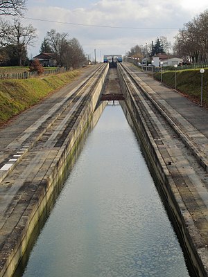
Water slope
Distance: Approx. 1134 meters
Latitude and longitude: 43.33027778,3.20111111
A water slope (French: Pente d'eau) is a type of canal inclined plane built to carry boats from a canal or river at one elevation up or down to a canal or river at another elevation.

Fonseranes Locks
Flight of locks on the Canal du Midi, France
Distance: Approx. 1213 meters
Latitude and longitude: 43.33055556,3.19972222
Fonseranes Locks (French: écluses de Fonseranes, les neuf écluses) are a flight of staircase locks on the Canal du Midi near Béziers. They consist of eight oval-shaped lock chambers, characteristic of the Canal du Midi, and nine gates, which allow boats to be raised a height of 21.5 metres (71 ft) over a distance of 300 metres (980 ft). The flight was originally built as an eight-rise, which together with the ninth lock (the écluse de Notre-Dame, 710 metres (0.44 mi) to the northeast) allowed boats to cross the Orb river on a level and re-enter the canal further downstream.

Roman Catholic Diocese of Béziers
Distance: Approx. 644 meters
Latitude and longitude: 43.3416,3.2107
The Roman Catholic Diocese of Béziers was situated in France. It is no longer an independent diocese, and is part of the Diocese of Montpellier. Traditionally, the first Bishop of Béziers is considered to be the Egyptian saint, Aphrodisius, said to have sheltered the Holy Family at Hermopolis and to have become a disciple of Christ, also to have accompanied Sergius Paulus to Gaul when the latter went thither to found the Church of Narbonne, and to have died a martyr at Béziers.

Béziers Cathedral
Distance: Approx. 638 meters
Latitude and longitude: 43.34138889,3.21
Béziers Cathedral (French: Cathédrale Saint-Nazaire-et-Saint-Celse de Béziers) is a Roman Catholic church located in Béziers, France. The edifice dates from the thirteenth century, having been erected on the site of an earlier building that was destroyed during the Massacre at Béziers in the Albigensian Crusade. The cathedral was formerly the seat of the Bishopric of Béziers, which was dissolved by the Concordat of 1801 and annexed into the Diocese of Montpellier.

Orb Aqueduct
Aqueduct carrying the Canal du Midi
Distance: Approx. 173 meters
Latitude and longitude: 43.33444444,3.21277778
The Orb Aqueduct (French: Pont-canal de l'Orb, Pont-canal de Béziers) is a bridge which carries the Canal du Midi over the Orb in the city of Béziers in Languedoc, France. The aqueduct is 28 metres (92 ft) wide, 12 metres (39 ft) tall and at 240 metres (790 ft) is the longest on the Canal du Midi. Prior to the opening of the aqueduct in 1858, the Canal du Midi traversed a short section of the Orb itself.

Fonseranes Water Slope
Former canal elevator
Distance: Approx. 1164 meters
Latitude and longitude: 43.330196,3.200744
The Fonseranes Water Slope (French: Pente d'eau Fonséranes) is a disused inclined plane on the Canal du Midi parallel to the Fonseranes Lock. It has a rise of 13.6 m (45 ft) and a slope of 5°. This technique for a water slope was described by the French engineer Jean Aubert in 1961.

Stade de Sauclières
Stadium in Béziers, France
Distance: Approx. 1120 meters
Latitude and longitude: 43.33138889,3.225
Stade de Sauclières is a stadium in Béziers, France. It is currently used for football matches and is the home stadium of AS Béziers. The stadium holds 2,004 spectators.

Béziers station
Railway station in France
Distance: Approx. 503 meters
Latitude and longitude: 43.3363,3.2189
Béziers station (French: Gare de Béziers; Occitan: Gara de Besièrs) is a French railway station that serves the town of Béziers in the Hérault département of southern France. It is on the Bordeaux–Sète railway.

Massacre at Béziers
1209 killing of Cathars during the Albigensian Crusade
Distance: Approx. 1388 meters
Latitude and longitude: 43.3476,3.219
The Massacre at Béziers occurred on 22 July 1209 during the sack of Béziers by crusaders. It was the first major military action of the Albigensian Crusade.

Canton of Béziers-2
Canton in Occitania, France
Distance: Approx. 740 meters
Latitude and longitude: 43.34,3.22
The canton of Béziers-2 is an administrative division of the Hérault department, southern France. Its borders were modified at the French canton reorganisation which came into effect in March 2015. Its seat is in Béziers.
Weather in this IP's area
overcast clouds
17 Celsius
17 Celsius
16 Celsius
17 Celsius
1024 hPa
88 %
1024 hPa
1021 hPa
10000 meters
4.63 m/s
70 degree
100 %
07:27:47
17:33:42
