Country:
 Great Britain
Region:
City:
Latitude and Longitude:
Time Zone:
Postal Code:
IP information under different IP Channel
ip-api
Country
Region
City
ASN
Time Zone
ISP
Blacklist
Proxy
Latitude
Longitude
Postal
Route
IPinfo
Country
Region
City
ASN
Time Zone
ISP
Blacklist
Proxy
Latitude
Longitude
Postal
Route
MaxMind
Country
Region
City
ASN
Time Zone
ISP
Blacklist
Proxy
Latitude
Longitude
Postal
Route
Luminati
Country
GBRegion
eng
City
burtonontrent
ASN
Time Zone
Europe/London
ISP
British Telecommunications PLC
Latitude
Longitude
Postal
db-ip
Country
Region
City
ASN
Time Zone
ISP
Blacklist
Proxy
Latitude
Longitude
Postal
Route
ipdata
Country
Region
City
ASN
Time Zone
ISP
Blacklist
Proxy
Latitude
Longitude
Postal
Route
Popular places and events near this IP address

Alrewas
Human settlement in England
Distance: Approx. 503 meters
Latitude and longitude: 52.732,-1.749
Alrewas ( AWL-ri-wəs) is a village and civil parish in the Lichfield District of Staffordshire, England.

Combined Operations Headquarters
Department of the British War Office during WWII which organized military raids on Germany
Distance: Approx. 1897 meters
Latitude and longitude: 52.7311,-1.723
Combined Operations Headquarters was a department of the British War Office set up during Second World War to harass the Germans on the European continent by means of raids carried out by use of combined naval and army forces.
National Memorial Arboretum
Site of remembrance, Staffordshire, England
Distance: Approx. 1702 meters
Latitude and longitude: 52.7282,-1.7285
The National Memorial Arboretum is a British site of national remembrance at Alrewas, near Lichfield, Staffordshire. Its objective is to honour the fallen, recognise service and sacrifice, and foster pride in the British Armed Forces and civilian community. In 2017, after undergoing a large scale regeneration project, the arboretum's new award-winning Remembrance Centre was officially opened by the Duke of Cambridge on 23 March.

Alrewas and Fradley
Human settlement in England
Distance: Approx. 1003 meters
Latitude and longitude: 52.73,-1.76
Alrewas and Fradley, was a large civil parish in the Lichfield district of Staffordshire, England. The parish included the villages of Alrewas, Fradley and Orgreave, and in 2001 had a population of 4,686.

Fradley
Human settlement in England
Distance: Approx. 2044 meters
Latitude and longitude: 52.72,-1.763
Fradley is a village and civil parish, in the Lichfield district, in the county of Staffordshire, England. In 1881 the parish had a population of 380.

Wychnor
Human settlement in England
Distance: Approx. 1022 meters
Latitude and longitude: 52.743,-1.739
Wychnor (or Wichnor, ) is a village and civil parish in Staffordshire, England. It is situated in the East Staffordshire local government district, adjoining Alrewas and Barton-under-Needwood. It is situated on the formerly Roman road Ryknild Street, current known as the A38, and contains the hamlet of Wychnor Bridges where the A38 crosses the River Trent.
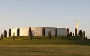
Armed Forces Memorial
United Kingdom national memorial in Staffordshire
Distance: Approx. 1835 meters
Latitude and longitude: 52.7274,-1.727
The Armed Forces Memorial is a national memorial in the United Kingdom, dedicated to the 16,000 servicemen and women of the British Armed Forces killed on duty or through terrorist action since after the Second World War. It is within the National Memorial Arboretum in Staffordshire.
Barton Green
Village in Staffordshire, England
Distance: Approx. 2005 meters
Latitude and longitude: 52.75,-1.73
Barton Green is a village in Staffordshire, England.
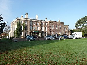
Wychnor Hall
Distance: Approx. 1499 meters
Latitude and longitude: 52.7482,-1.7607
Wychnor Hall (or Wychnor Park, ) is Grade II Listed early 18th-century country house near Burton on Trent, Staffordshire, formerly owned by the Levett Family. The hall has been converted to a Country Club.

Alrewas railway station
Disused railway station in Alrewas, Lichfield
Distance: Approx. 971 meters
Latitude and longitude: 52.7304,-1.7394
Alrewas railway station was a station on the South Staffordshire Railway, which served the village of Alrewas, Staffordshire. The station was located next to a level crossing, although the main road, now the A513, now crosses the railway line via a bridge.
All Saints Church, Alrewas
Church in Staffordshire, England
Distance: Approx. 300 meters
Latitude and longitude: 52.734764,-1.753095
All Saints Church, Alrewas is a parish church in the village of Alrewas, Staffordshire in England. The church is situated in the north west of the village on the north side of the Trent & Mersey Canal. The church is a Grade I Listed Building.
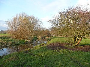
River Swarbourn
River in Staffordshire, England
Distance: Approx. 829 meters
Latitude and longitude: 52.74133,-1.75906
The River Swarbourn is a minor tributary of the River Trent that flows for 10 miles (16 km) in Staffordshire, England.
Weather in this IP's area
overcast clouds
17 Celsius
17 Celsius
16 Celsius
18 Celsius
1005 hPa
96 %
1005 hPa
998 hPa
10000 meters
3.22 m/s
6.23 m/s
44 degree
100 %
06:29:58
19:39:34