Country:
 Gibraltar
Region:
City:
Latitude and Longitude:
Time Zone:
Postal Code:
IP information under different IP Channel
ip-api
Country
Region
City
ASN
Time Zone
ISP
Blacklist
Proxy
Latitude
Longitude
Postal
Route
IPinfo
Country
Region
City
ASN
Time Zone
ISP
Blacklist
Proxy
Latitude
Longitude
Postal
Route
MaxMind
Country
Region
City
ASN
Time Zone
ISP
Blacklist
Proxy
Latitude
Longitude
Postal
Route
Luminati
Country
 IM
IMASN
Time Zone
Europe/Isle_of_Man
ISP
CL-1379-14537
Latitude
Longitude
Postal
db-ip
Country
Region
City
ASN
Time Zone
ISP
Blacklist
Proxy
Latitude
Longitude
Postal
Route
ipdata
Country
Region
City
ASN
Time Zone
ISP
Blacklist
Proxy
Latitude
Longitude
Postal
Route
Popular places and events near this IP address

Cathedral of St. Mary the Crowned
Church in Main Street, Gibraltar
Distance: Approx. 76 meters
Latitude and longitude: 36.139672,-5.35366
The Cathedral of Saint Mary the Crowned (Spanish: Catedral de Santa María la Coronada) is a Latin Catholic cathedral in Gibraltar. It is the primary centre of Catholic worship in the Diocese of Gibraltar.

Main Street, Gibraltar
Distance: Approx. 65 meters
Latitude and longitude: 36.139682,-5.353794
Main Street (Spanish: Calle Real) is the main arterial street in the British overseas territory of Gibraltar.

Great Siege of Gibraltar
Failed Franco-Spanish attempt to capture Gibraltar (1779–1783)
Distance: Approx. 60 meters
Latitude and longitude: 36.1397,-5.3551
The Great Siege of Gibraltar was an unsuccessful attempt by Spain and France to capture Gibraltar from the British during the American Revolutionary War. It was the largest battle in the war by number of combatants. On 16 June 1779, Spain entered the war on the side of France and as co-belligerents of the revolutionary United Colonies—the British base at Gibraltar was Spain's primary war aim.

Capture of Gibraltar
1704 capture by the Anglo-Dutch fleet
Distance: Approx. 57 meters
Latitude and longitude: 36.1397,-5.3539
The capture of Gibraltar by Anglo-Dutch forces of the Grand Alliance occurred between 1 and 4 August 1704 during the War of the Spanish Succession. Since the beginning of the war the Alliance had been looking for a harbour in the Iberian Peninsula to control the Strait of Gibraltar and facilitate naval operations against the French fleet in the western Mediterranean Sea. An attempt to seize Cádiz had ended in failure in September 1702, but following the Alliance fleet's successful raid in Vigo Bay in October that year, the combined fleets of the "Maritime Powers", the Netherlands and England, had emerged as the dominant naval force in the region.

Gibraltar National Museum
National museum in Bomb House Lane, Gibraltar
Distance: Approx. 56 meters
Latitude and longitude: 36.139,-5.3544
The Gibraltar National Museum is a national museum of the history, culture and natural history of Gibraltar located within the city centre of the British overseas territory of Gibraltar. Founded in 1930 by the then Governor of Gibraltar, General Sir Alexander Godley, the museum houses an array of displays portraying The Rock's millennia-old history and the unique culture of its people. The museum also incorporates the remains of a 14th-century Moorish bathhouse.

Bristol Hotel, Gibraltar
Hotel in Gibraltar
Distance: Approx. 68 meters
Latitude and longitude: 36.13888889,-5.35444444
Bristol Hotel is Gibraltar's oldest hotel. It is located on Cathedral Square in Gibraltar, next to the Church of England Cathedral of The Holy Trinity. Established in 1894 the 19th century, it occupies a white colonial building with swimming pool and garden, located to the south of Cathedral of St.
Gibraltar Heritage Trust
Distance: Approx. 127 meters
Latitude and longitude: 36.1406,-5.3541
The Gibraltar Heritage Trust is a non-profit charity established by statute on 1 May 1989 to preserve and promote the cultural natural heritage of the British Overseas Territory of Gibraltar.
Ninth siege of Gibraltar
Distance: Approx. 120 meters
Latitude and longitude: 36.14,-5.3533
The ninth siege of Gibraltar was a fifteen-month-long siege of the town of Gibraltar that lasted from 1466 until 1467. The siege was conducted by Juan Alonso de Guzmán, the 1st Duke of Medina Sidonia, and resulted in a takeover of the town, then belonging to the Crown of Castile. Unlike other sieges of Gibraltar, which were the result of clashes between different powers, this was a purely internal struggle between rival Castilian factions.

King's Bastion
18C fortifications in Gibraltar
Distance: Approx. 60 meters
Latitude and longitude: 36.139701,-5.355099
King's Bastion is a coastal bastion on the western front of the fortifications of the British overseas territory of Gibraltar, protruding from the Line Wall Curtain. It is located between Line Wall Road and Queensway and overlooks the Bay of Gibraltar . It played a crucial role in defending The Rock during the Great Siege of Gibraltar.
Algeciras Gate
Distance: Approx. 40 meters
Latitude and longitude: 36.139707,-5.354849
Algeciras Gate was a city gate in the British Overseas Territory of Gibraltar.
Gibraltar Hebrew School
Distance: Approx. 41 meters
Latitude and longitude: 36.1393,-5.3541
Gibraltar Hebrew School, also Talmud Torah Hebrew School, is a government school in the British Overseas Territory of Gibraltar. The foundation stone of the school, designed by Samuel Levy, was laid on 3 September 1895 in a ceremony attended by the Rabbi of Gibraltar and the local Jewish community. It was inaugurated in 1898.
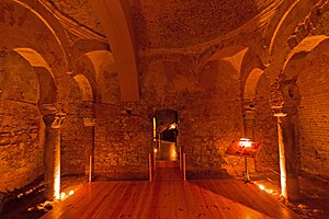
Moorish Baths, Gibraltar
Medieval in Gibraltar, Gibraltar
Distance: Approx. 56 meters
Latitude and longitude: 36.139,-5.3544
The Moorish Baths are located in the basement of the Gibraltar Museum in the city of Gibraltar, a British overseas territory. One of the best-preserved Moorish bath houses in Europe, the early 14th century baths bear resemblance to the Roman hypocaust system, and have four chambers with pillars.
Weather in this IP's area
broken clouds
21 Celsius
21 Celsius
21 Celsius
21 Celsius
1013 hPa
87 %
1013 hPa
1011 hPa
10000 meters
2.57 m/s
250 degree
75 %
07:58:50
20:39:31