Country:
Region:
City:
Latitude and Longitude:
Time Zone:
Postal Code:
IP information under different IP Channel
ip-api
Country
Region
City
ASN
Time Zone
ISP
Blacklist
Proxy
Latitude
Longitude
Postal
Route
Luminati
Country
ASN
Time Zone
Europe/Isle_of_Man
ISP
CL-1379-14537
Latitude
Longitude
Postal
IPinfo
Country
Region
City
ASN
Time Zone
ISP
Blacklist
Proxy
Latitude
Longitude
Postal
Route
db-ip
Country
Region
City
ASN
Time Zone
ISP
Blacklist
Proxy
Latitude
Longitude
Postal
Route
ipdata
Country
Region
City
ASN
Time Zone
ISP
Blacklist
Proxy
Latitude
Longitude
Postal
Route
Popular places and events near this IP address

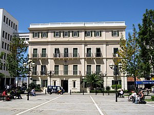
Gibraltar Parliament
Legislature of the British overseas territory of Gibraltar
Distance: Approx. 16 meters
Latitude and longitude: 36.140775,-5.353758
The Gibraltar Parliament is the legislature of the British overseas territory of Gibraltar. Between 1969 and 2006, it was called the Gibraltar House of Assembly.

Cathedral of St. Mary the Crowned
Church in Main Street, Gibraltar
Distance: Approx. 126 meters
Latitude and longitude: 36.139672,-5.35366
The Cathedral of Saint Mary the Crowned (Spanish: Catedral de Santa María la Coronada) is a Latin Catholic cathedral in Gibraltar. It is the primary centre of Catholic worship in the Diocese of Gibraltar.
Main Street, Gibraltar
Distance: Approx. 126 meters
Latitude and longitude: 36.139682,-5.353794
Main Street (Spanish: Calle Real) is the main arterial street in the British overseas territory of Gibraltar.
Panorama (Gibraltar)
Daily Newspaper in Gibraltar
Distance: Approx. 59 meters
Latitude and longitude: 36.141174,-5.354038
Panorama was a daily newspaper published in Gibraltar.

Capture of Gibraltar
1704 capture by the Anglo-Dutch fleet
Distance: Approx. 126 meters
Latitude and longitude: 36.1397,-5.3539
The capture of Gibraltar by Anglo-Dutch forces of the Grand Alliance occurred between 1 and 4 August 1704 during the War of the Spanish Succession. Since the beginning of the war the Alliance had been looking for a harbour in the Iberian Peninsula to control the Strait of Gibraltar and facilitate naval operations against the French fleet in the western Mediterranean Sea. An attempt to seize Cádiz had ended in failure in September 1702, but following the Alliance fleet's successful raid in Vigo Bay in October that year, the combined fleets of the "Maritime Powers", the Netherlands and England, had emerged as the dominant naval force in the region.
Royal Gibraltar Post Office
Distance: Approx. 125 meters
Latitude and longitude: 36.141909,-5.353397
The Royal Gibraltar Post Office is the postal services in the British overseas territory of Gibraltar. It is currently a department within the Government of Gibraltar.

Gibraltar City Hall
Former city hall for Gibraltar
Distance: Approx. 79 meters
Latitude and longitude: 36.140853,-5.354454
The Gibraltar City Hall is the former city hall for Gibraltar, centrally located within the city at the west end of John Mackintosh Square. It is the office of the Mayor of Gibraltar and since 2023 has been the location of the Registry of Marriages.

John Mackintosh Square
Square in Gibraltar
Distance: Approx. 53 meters
Latitude and longitude: 36.1408375,-5.35416944
John Mackintosh Square (colloquially The Piazza) is a main square in the British overseas territory of Gibraltar. It has been the centre of city life since the 14th century and takes its name from John Mackintosh, a local philanthropist. Notable buildings on John Mackintosh Square include the Parliament Building and the City Hall.

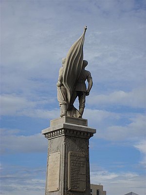
Gibraltar War Memorial
Monument in Line Wall Road, Gibraltar
Distance: Approx. 109 meters
Latitude and longitude: 36.140794,-5.354798
The Gibraltar War Memorial is a First World War monument located on Line Wall Road in the British Overseas Territory of Gibraltar. Also known as the British War Memorial, it was sculpted by Jose Piquet Catoli of Spain and unveiled in 1923. Adjacent to the monument on the esplanade built in 1921 are several memorial tablets, as well as two Russian guns from the Crimean War.

Main Guard (Gibraltar)
Guardhouse in John Mackintosh Square, Gibraltar
Distance: Approx. 55 meters
Latitude and longitude: 36.14062,-5.354147
The Main Guard is a historic, 18th-century guardhouse in the British Overseas Territory of Gibraltar. While the exact date of its construction is unknown, it is the oldest building in John Mackintosh Square. The French artist Henri Regnault produced three paintings while a visitor at the Main Guard.
Gibraltar Heritage Trust
Distance: Approx. 52 meters
Latitude and longitude: 36.1406,-5.3541
The Gibraltar Heritage Trust is a non-profit charity established by statute on 1 May 1989 to preserve and promote the cultural natural heritage of the British Overseas Territory of Gibraltar.
Ninth siege of Gibraltar
Distance: Approx. 93 meters
Latitude and longitude: 36.14,-5.3533
The ninth siege of Gibraltar was a fifteen-month-long siege of the town of Gibraltar that lasted from 1466 until 1467. The siege was conducted by Juan Alonso de Guzmán, the 1st Duke of Medina Sidonia, and resulted in a takeover of the town, then belonging to the Crown of Castile. Unlike other sieges of Gibraltar, which were the result of clashes between different powers, this was a purely internal struggle between rival Castilian factions.
Weather in this IP's area
mist
19 Celsius
19 Celsius
19 Celsius
19 Celsius
1015 hPa
90 %
1015 hPa
1014 hPa
7000 meters
5.14 m/s
70 degree
75 %
07:58:37
18:13:46
