109.200.95.2 - IP Lookup: Free IP Address Lookup, Postal Code Lookup, IP Location Lookup, IP ASN, Public IP
Country:
Region:
City:
Location:
Time Zone:
Postal Code:
ISP:
ASN:
language:
User-Agent:
Proxy IP:
Blacklist:
IP information under different IP Channel
ip-api
Country
Region
City
ASN
Time Zone
ISP
Blacklist
Proxy
Latitude
Longitude
Postal
Route
db-ip
Country
Region
City
ASN
Time Zone
ISP
Blacklist
Proxy
Latitude
Longitude
Postal
Route
IPinfo
Country
Region
City
ASN
Time Zone
ISP
Blacklist
Proxy
Latitude
Longitude
Postal
Route
IP2Location
109.200.95.2Country
Region
lubelskie
City
swidnik
Time Zone
Europe/Warsaw
ISP
Language
User-Agent
Latitude
Longitude
Postal
ipdata
Country
Region
City
ASN
Time Zone
ISP
Blacklist
Proxy
Latitude
Longitude
Postal
Route
Popular places and events near this IP address

Świdnik
Place in Lublin Voivodeship, Poland
Distance: Approx. 371 meters
Latitude and longitude: 51.21666667,22.7
Świdnik (Polish pronunciation: [ˈɕfidɲik]) is a town in southeastern Poland with 40,186 inhabitants (2012), situated in the Lublin Voivodeship, 10 kilometres (6 miles) southeast of the city of Lublin. It is the capital of Świdnik County. Świdnik belongs to the historic province of Lesser Poland, and was first mentioned in historical records in the year 1392.

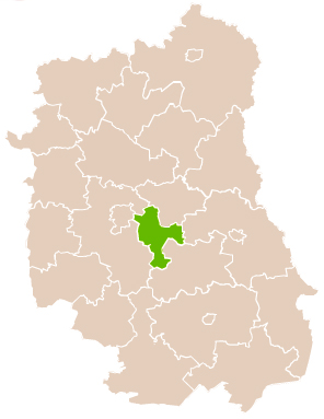
Świdnik County
County in Lublin Voivodeship, Poland
Distance: Approx. 371 meters
Latitude and longitude: 51.21666667,22.7
Świdnik County (Polish: powiat świdnicki) is a unit of territorial administration and local government (powiat) in Lublin Voivodeship, eastern Poland. It was established on January 1, 1999, as a result of the Polish local government reforms passed in 1998. Its administrative seat and largest city is Świdnik, which lies 10 kilometres (6 mi) east of the regional capital Lublin.

Kalinówka, Lublin County
Village in Lublin Voivodeship, Poland
Distance: Approx. 3049 meters
Latitude and longitude: 51.20416667,22.65944444
Kalinówka [kaliˈnufka] is a village in the administrative district of Gmina Głusk, within Lublin County, Lublin Voivodeship, in eastern Poland.
Kazimierzówka
Village in Lublin Voivodeship, Poland
Distance: Approx. 3778 meters
Latitude and longitude: 51.18666667,22.67972222
Kazimierzówka [kaʑimjɛˈʐufka] is a village in the administrative district of Gmina Głusk, within Lublin County, Lublin Voivodeship, in eastern Poland.
Kolonia Świdnik Mały
Village in Lublin Voivodeship, Poland
Distance: Approx. 3480 meters
Latitude and longitude: 51.24805556,22.67777778
Kolonia Świdnik Mały [kɔˈlɔɲa ˈɕfidnik ˈmawɨ] is a village in the administrative district of Gmina Wólka, within Lublin County, Lublin Voivodeship, in eastern Poland.
Świdnik Duży
Village in Lublin Voivodeship, Poland
Distance: Approx. 3566 meters
Latitude and longitude: 51.25,22.68333333
Świdnik Duży [ˈɕfidnik ˈduʐɨ] is a village in the administrative district of Gmina Wólka, within Lublin County, Lublin Voivodeship, in eastern Poland. It lies approximately 8 km (5 mi) east of the regional capital Lublin.
Franciszków, Świdnik County
Village in Lublin Voivodeship, Poland
Distance: Approx. 2602 meters
Latitude and longitude: 51.21666667,22.73333333
Franciszków (Polish pronunciation: [fraɲˈt͡ɕiʂkuf]) is a village in the administrative district of Gmina Mełgiew, within Świdnik County, Lublin Voivodeship, in eastern Poland. It lies approximately 3 kilometres (2 mi) east of Świdnik and 12 km (7 mi) east of the regional capital Lublin.
Jacków, Lublin Voivodeship
Village in Lublin Voivodeship, Poland
Distance: Approx. 3106 meters
Latitude and longitude: 51.23027778,22.73694444
Jacków [ˈjat͡skuf] is a village in the administrative district of Gmina Mełgiew, within Świdnik County, Lublin Voivodeship, in eastern Poland.
Krępiec, Lublin Voivodeship
Village in Lublin Voivodeship, Poland
Distance: Approx. 3344 meters
Latitude and longitude: 51.2,22.73333333
Krępiec [ˈkrɛmpjɛt͡s] is a village in the administrative district of Gmina Mełgiew, within Świdnik County, Lublin Voivodeship, in eastern Poland. It lies approximately 4 kilometres (2 mi) south-west of Mełgiew, 3 km (2 mi) south-east of Świdnik, and 13 km (8 mi) south-east of the regional capital Lublin.
Nowy Krępiec
Village in Lublin Voivodeship, Poland
Distance: Approx. 3774 meters
Latitude and longitude: 51.20722222,22.74694444
Nowy Krępiec [ˈnɔvɨ ˈkrɛmpjɛt͡s] is a village in the administrative district of Gmina Mełgiew, within Świdnik County, Lublin Voivodeship, in eastern Poland.

Lublin Airport
Airport in the east of Poland
Distance: Approx. 2661 meters
Latitude and longitude: 51.24027778,22.71361111
Lublin Airport (Port Lotniczy Lublin) (IATA: LUZ, ICAO: EPLB) is an airport in Poland serving Lublin and the surrounding region. The site is located about 10 km (6.2 miles) east of central Lublin, adjacent to the town of Świdnik. The airport has a 2520 × (45 + 2 × 7.5) m runway (8,270 × 200 ft), and the terminal facilities are capable of handling four Boeing 737-800 class aircraft simultaneously.

Lublin Airport railway station
Railway station in Świdnik, Poland
Distance: Approx. 2210 meters
Latitude and longitude: 51.23472222,22.71555556
Lublin Airport is a railway station in Świdnik, in the Świdnik County, Lublin Voivodeship, located within the Lublin Airport area.
Weather in this IP's area
clear sky
9 Celsius
6 Celsius
9 Celsius
9 Celsius
1010 hPa
71 %
1010 hPa
985 hPa
10000 meters
5.14 m/s
180 degree
