Country:
 Russian Federation
Region:
City:
Latitude and Longitude:
Time Zone:
Postal Code:
IP information under different IP Channel
ip-api
Country
Region
City
ASN
Time Zone
ISP
Blacklist
Proxy
Latitude
Longitude
Postal
Route
IPinfo
Country
Region
City
ASN
Time Zone
ISP
Blacklist
Proxy
Latitude
Longitude
Postal
Route
MaxMind
Country
Region
City
ASN
Time Zone
ISP
Blacklist
Proxy
Latitude
Longitude
Postal
Route
Luminati
Country
RUASN
Time Zone
Europe/Moscow
ISP
JSC ER-Telecom Holding
Latitude
Longitude
Postal
db-ip
Country
Region
City
ASN
Time Zone
ISP
Blacklist
Proxy
Latitude
Longitude
Postal
Route
ipdata
Country
Region
City
ASN
Time Zone
ISP
Blacklist
Proxy
Latitude
Longitude
Postal
Route
Popular places and events near this IP address
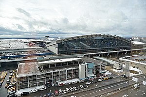
Vnukovo International Airport
International airport serving Moscow, Russia
Distance: Approx. 6105 meters
Latitude and longitude: 55.59611111,37.2675
Vnukovo, formally Vnukovo Andrei Tupolev International Airport (named after Andrei Tupolev) (Russian: Внуково, IPA: [ˈvnukəvə]) (IATA: VKO, ICAO: UUWW), is a dual-runway international airport located in Vnukovo District, 28 km (17 mi) southwest of the centre of Moscow, Russia. It is one of the four major airports that serve Moscow, along with Domodedovo, Sheremetyevo, and Zhukovsky. In 2019, the airport handled 24.01 million passengers, representing an increase of 12% compared to the previous year.
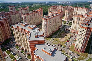
Troitsk, Moscow
Town in Moscow, Russia
Distance: Approx. 6560 meters
Latitude and longitude: 55.49138889,37.30916667
Troitsk (Russian: Тро́ицк) is a town in Troitsky Administrative Okrug of the federal city of Moscow, Russia, located on the Desna River 37 kilometers (23 mi) southwest from the center of Moscow on the Kaluzhskoye Highway. Population: 39,873 (2010 Census); 32,653 (2002 Census); 29,301 (1989 Soviet census).

M3 highway (Russia)
Road in Russia
Distance: Approx. 6991 meters
Latitude and longitude: 55.57527778,37.21833333
The Russian route M3 (also known as the Ukraine Highway) is a major trunk road that runs across a distance of about 490 kilometres from Moscow to Russia's border with Ukraine. The highway starts at the crossing of Leninsky Prospekt and Moscow Ring Road as Kiyevskoye Highway, passes south of Solntsevo and Vnukovo, then continues westward through Kaluga, Bryansk and Sevsk to the Ukrainian border. After crossing the border, the road continues as the Ukrainian M02 route to Kyiv.
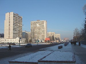
Moskovsky, Moscow
Town in Moscow, Russia
Distance: Approx. 5877 meters
Latitude and longitude: 55.6,37.35
Moskovsky (Russian: Моско́вский) is a town in Moskovsky Settlement of Moscow. The town of Moskovsky was formerly located in Leninsky District of Moscow Oblast, Russia, and since July 2012 it is a part of the federal city of Moscow. It is located 25 kilometers (16 mi) southwest of the center Moscow and 5 kilometers (3.1 mi) east of Vnukovo International Airport.

Vnukovo District
District in Moscow, Russia
Distance: Approx. 6081 meters
Latitude and longitude: 55.59972222,37.28
Vnukovo District (Russian: район Внуково) is an administrative district (raion) of Western Administrative Okrug, and one of the 125 raions of Moscow, Russia. Most of the district is occupied by Vnukovo International Airport, a small adjacent residential area, and a separate residential micro-district. The area of the district is 16.912 square kilometers (6.530 sq mi), and its population was estimated at 20,100 as of 2017.
Troitsky Administrative Okrug
Administrative okrug of Moscow in Russia
Distance: Approx. 6560 meters
Latitude and longitude: 55.49138889,37.30916667
Troitsky Administrative Okrug (Russian: Троицкий административный округ) is one of the twelve administrative okrugs of Moscow. The okrug was founded on July 1, 2012.
Novomoskovsky Administrative Okrug
Administrative okrug of Moscow in Russia
Distance: Approx. 5877 meters
Latitude and longitude: 55.6,37.35
Novomoskovsky Administrative Okrug (Russian: Новомосковский административный округ) is one of the twelve administrative okrugs of Moscow. The okrug was created on July 1, 2012. The administrative center of Novomoskovsky Administrative Okrug is the town of Moskovsky.

Red Wings Airlines Flight 9268
2012 aviation accident
Distance: Approx. 5565 meters
Latitude and longitude: 55.58388889,37.255
Red Wings Airlines Flight 9268 was a Tupolev Tu-204-100 passenger jet that on 29 December 2012 crashed on landing at Moscow Vnukovo Airport, Russia, following a repositioning flight from Pardubice Airport, Czech Republic. There were no passengers on board, but 5 of the 8 crew members were killed when the aircraft hit a ditch and highway structures after overrunning the runway. The accident marked the second hull-loss of a Tupolev Tu-204, as well as the type's first fatal accident since its introduction in 1989.

August 1969 Il-18 crash
Distance: Approx. 5763 meters
Latitude and longitude: 55.59416667,37.27222222
On Tuesday, August 26 1969, an Aeroflot Il-18 crashed at Vnukovo Airport. Of the 101 people on board, 16 were killed.

Unijet Flight 074P
Distance: Approx. 6103 meters
Latitude and longitude: 55.5961,37.2675
On 20 October 2014, Unijet Flight 074, a Dassault Falcon 50 business jet taking off from Vnukovo International Airport in Moscow, Russia, crashed into a snow plow that had strayed onto the runway, killing all four people on board. Among the victims was Total's Chairman and CEO Christophe de Margerie, who was returning to Paris, France. The driver of the snow removal vehicle, who was injured in the collision, was found to have alcohol in his blood and subsequently pleaded guilty to causing de Margerie's death.
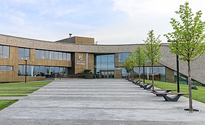
Letovo School
Private boarding school in Moscow, Russia
Distance: Approx. 6535 meters
Latitude and longitude: 55.55767,37.4229
Letovo School is a private non-profit co-educational boarding school in Letovo, Novomoskovskiy, Moscow, Russia. It was established in 2018 and has a total capacity of 1,000 students.

Aeroport Vnukovo (Moscow Metro)
Moscow Metro station
Distance: Approx. 6615 meters
Latitude and longitude: 55.60666667,37.28833333
Aeroport Vnukovo (Russian: Аэропорт Внуково ) is a Moscow Metro station, the western terminus of the Kalininsko-Solntsevskaya line. The station serves the Vnukovo International Airport. It is the westernmost station on the Moscow Metro.
Weather in this IP's area
clear sky
13 Celsius
12 Celsius
13 Celsius
13 Celsius
1028 hPa
76 %
1028 hPa
1007 hPa
10000 meters
3 m/s
10 degree
06:12:37
18:35:39