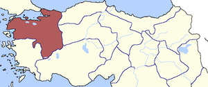
Country:
 Turkey
Region:
City:
Latitude and Longitude:
Time Zone:
Postal Code:
IP information under different IP Channel
ip-api
Country
Region
City
ASN
Time Zone
ISP
Blacklist
Proxy
Latitude
Longitude
Postal
Route
IPinfo
Country
Region
City
ASN
Time Zone
ISP
Blacklist
Proxy
Latitude
Longitude
Postal
Route
MaxMind
Country
Region
City
ASN
Time Zone
ISP
Blacklist
Proxy
Latitude
Longitude
Postal
Route
Luminati
Country
TRRegion
16
City
bursa
ASN
Time Zone
Europe/Istanbul
ISP
Ae Olfe Teknoloji Ve Ticaret Limited Sirketi
Latitude
Longitude
Postal
db-ip
Country
Region
City
ASN
Time Zone
ISP
Blacklist
Proxy
Latitude
Longitude
Postal
Route
ipdata
Country
Region
City
ASN
Time Zone
ISP
Blacklist
Proxy
Latitude
Longitude
Postal
Route
Popular places and events near this IP address

Bursa
City in Bursa province in western Turkey
Distance: Approx. 2140 meters
Latitude and longitude: 40.18333333,29.05
Bursa (Turkish pronunciation: [ˈbuɾsa]) is a city in northwestern Turkey and the administrative center of Bursa Province. The fourth-most populous city in Turkey and second-most populous in the Marmara Region, Bursa is one of the industrial centers of the country. Most of Turkey's automotive production takes place in Bursa.
Bursa Atatürk Sport Hall
Distance: Approx. 1901 meters
Latitude and longitude: 40.19423,29.04839
Bursa Atatürk Sport Hall (Turkish: Bursa Atatürk Spor Salonu) is a multi-purpose indoor sport venue located in the district of Altıparmak, Osmangazi in Bursa, Turkey. The hall, with a capacity for 3,000 people, was built in 1972. Home of four clubs Bursaspor Basketbol, Oyak Renault Basketball, Yeşim SK and Uludağ Üniversitesi SK, it is the biggest indoor sport hall in Bursa, where competitions of basketball, volleyball and handball are held.

Hüdavendigâr vilayet
First-level administrative division of the Ottoman Empire
Distance: Approx. 2140 meters
Latitude and longitude: 40.18333333,29.05
The Hüdavendigâr Vilayet (Ottoman Turkish: ولايت خداوندگار, romanized: Vilâyet-i Hüdavendigâr) or Bursa Vilayet after its administrative centre, was a first-level administrative division (vilayet) of the Ottoman Empire. At the beginning of the 20th century it reportedly had an area of 26,248 square miles (67,980 km2).
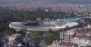
Bursa Atatürk Stadium
Turkish football stadium
Distance: Approx. 1901 meters
Latitude and longitude: 40.19264722,29.04875556
Bursa Atatürk Stadium (Turkish: Bursa Atatürk Stadyumu) was a multi-purpose stadium in Bursa, Turkey. It was used mostly for football matches and was the home ground of Bursaspor. The stadium held 25,213 and was built in 1979.

Bursaray
Rapid transit system of Bursa, Turkey
Distance: Approx. 2140 meters
Latitude and longitude: 40.18333333,29.05
Bursaray (sometimes stylized as BursaRay) is a rapid transit system in the city of Bursa, Marmara Region, Turkey, built in 2000 by TÜVASAŞ, and operated by Burulaş. The name Bursaray is a portmanteau of Bursa, and Ray, the Turkish word for "rail". The Bursaray metro opened for passenger service on 24 April 2002.

Muradiye Complex
Mausoleums of Ottoman royalty
Distance: Approx. 1663 meters
Latitude and longitude: 40.190853,29.046144
The Muradiye Complex (Turkish: Muradiye Külliyesi) or the Complex of Sultan Murad II, the Ottoman sultan (reigned 1421–1451, with interruption 1444–46), is located in Bursa, Turkey. It is part of the historic UNESCO World Heritage Site.
Hüdavendigâr Eyalet
Administrative division of the Ottoman Empire from 1827 to 1867
Distance: Approx. 2140 meters
Latitude and longitude: 40.18333333,29.05
Hüdavendigâr Eyalet (Ottoman Turkish: ایالت خداوندگار, romanized: Eyālet-i Ḥüdāvendigār) was an eyalet of the Ottoman Empire. The word Hüdavendigâr comes from the Persian word Khodāvandgār which literally translates to "devotee of god".

Hüdavendigar Mosque
Mosque in Bursa, Turkey
Distance: Approx. 1404 meters
Latitude and longitude: 40.20222222,29.02083333
Hüdavendigar Mosque or Murat I, the Hüdavendigar Mosque (Turkish: Hüdavendigar Camii or 1. Murat Hüdavendigar Camii) is a historic mosque in Bursa, Turkey, that is part of the large complex (külliye) built by the Ottoman Sultan, Murad I, between 1365–1385 and is also named after the same sultan. It went under extensive renovation following the 1855 Bursa earthquake.

Bursa Archaeological Museum
Archaeology museum in Çekirge, Bursa
Distance: Approx. 1374 meters
Latitude and longitude: 40.19583333,29.04111111
Bursa Archaeological Museum (Turkish: Bursa Arkeoloji Müzesi), shortly Bursa Museum, is a national museum in Bursa, Turkey, exhibiting archaeological artifacts found in and around the province.

Bursa Atatürk Museum
Historic house museum in Osmangazi, Bursa Turkey
Distance: Approx. 1249 meters
Latitude and longitude: 40.195,29.04
Bursa Atatürk Museum (Turkish: Bursa Atatürk Evi Müzesi) is a historic house museum in Bursa, Turkey. The museum is at 40°11′42″N 29°02′24″E at Çekirge quarter of Osmangazi district in Bursa Province. The museum is a three-storey house.
Bursa Forestry Museum
Distance: Approx. 1187 meters
Latitude and longitude: 40.1999,29.032928
Bursa Forestry Museum (Turkish: Bursa Ormancılık Müzesi) is a museum in Bursa, northwestern Turkey dedicated to forestry. Opened in 1989, it is housed in a historic Ottoman era mansion. Its collection size is nearly 1,000 items.
Bursa Karagöz Museum
Distance: Approx. 1295 meters
Latitude and longitude: 40.202029,29.02714
Bursa Karagöz Museum (Turkish: Bursa Karagöz Müzesi) is a museum located at Osmangazi in Bursa, northwestern Turkey, dedicated to the folkloric shadow play figures Karagöz and Hacivat. It was established in 2007.
Weather in this IP's area
broken clouds
25 Celsius
25 Celsius
25 Celsius
25 Celsius
1009 hPa
33 %
1009 hPa
953 hPa
10000 meters
3.4 m/s
4.87 m/s
308 degree
63 %
07:09:19
18:32:02