Country:
 Great Britain
Region:
City:
Latitude and Longitude:
Time Zone:
Postal Code:
IP information under different IP Channel
ip-api
Country
Region
City
ASN
Time Zone
ISP
Blacklist
Proxy
Latitude
Longitude
Postal
Route
IPinfo
Country
Region
City
ASN
Time Zone
ISP
Blacklist
Proxy
Latitude
Longitude
Postal
Route
MaxMind
Country
Region
City
ASN
Time Zone
ISP
Blacklist
Proxy
Latitude
Longitude
Postal
Route
Luminati
Country
GBASN
Time Zone
Europe/London
ISP
Iomart Cloud Services Limited
Latitude
Longitude
Postal
db-ip
Country
Region
City
ASN
Time Zone
ISP
Blacklist
Proxy
Latitude
Longitude
Postal
Route
ipdata
Country
Region
City
ASN
Time Zone
ISP
Blacklist
Proxy
Latitude
Longitude
Postal
Route
Popular places and events near this IP address

Wimbledon Chase railway station
Railway station in South London
Distance: Approx. 547 meters
Latitude and longitude: 51.4095,-0.2142
Wimbledon Chase railway station is in the London Borough of Merton in South London. The station is served by Thameslink trains on the Sutton Loop Line. It is in Travelcard Zone 3 and is arranged as an island eight-car platform, with stairs descending to street level towards the southern end.
Wimbledon (UK Parliament constituency)
Parliamentary constituency in the United Kingdom, 1885 onwards
Distance: Approx. 420 meters
Latitude and longitude: 51.417,-0.218
Wimbledon is a constituency in Greater London represented in the House of Commons of the UK Parliament. Since 2024, the seat has been held by Paul Kohler of the Liberal Democrats.

Wimbledon College of Arts
Art school of the University of the Arts London
Distance: Approx. 503 meters
Latitude and longitude: 51.41333333,-0.21194444
The Wimbledon College of Arts, formerly Wimbledon School of Art, is a constituent college of the University of the Arts London, a public art university in London, England. The college specialises in theatre, screen and performance art. It is located in Wimbledon and Merton Park, South West London.
Wimbledon College
Voluntary aided school in London, England
Distance: Approx. 633 meters
Latitude and longitude: 51.4188,-0.2215
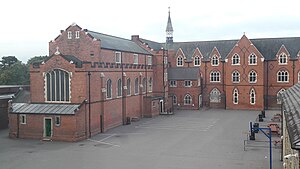
Wimbledon College is a government-maintained, voluntary-aided, Jesuit Catholic secondary school and sixth form for boys aged 11 to 19 in Wimbledon, London. The college was founded in 1892 "for improvement in living and learning for the greater glory of God and the common good." It is affiliated with the Sacred Heart Church and Donhead Preparatory School, its former feeder preparatory school. It is also affiliated with the Ursuline High School, the college's sister school, who have worked in partnership since 1986.

Ursuline High School, Wimbledon
Voluntary aided comprehensive school in Wimbledon, Greater London, England
Distance: Approx. 256 meters
Latitude and longitude: 51.414,-0.2227
The Ursuline High School, Wimbledon (“the Ursuline”) is a voluntary-aided, Roman Catholic Secondary School for girls aged 11 to 19. The school is based at Crescent Road and the Downs, Wimbledon, London. It was founded in 1892 by the Ursulines.

Sacred Heart Church, Wimbledon
Catholic church in London, England
Distance: Approx. 490 meters
Latitude and longitude: 51.4177,-0.2194
Sacred Heart Church is a Roman Catholic church and parish in Wimbledon, South West London initially run by the Jesuits, that serves the Catholic community of Wimbledon and surrounding areas. It is in the Archdiocese of Southwark and is situated next to Wimbledon College and Donhead Preparatory School. The main entrance to the church is on Edge Hill road, but the church can also be accessed from the adjacent Darlaston Road.
Donhead Preparatory School
Private, preparatory, day school in Merton, London, England
Distance: Approx. 566 meters
Latitude and longitude: 51.418,-0.2223
Donhead is an all-male private, preparatory day school located in Wimbledon, in the London Borough of Merton. The school is under the governance of the Jesuits, a Catholic religious order founded by Ignatius of Loyola in 1540. Donhead takes boys aged 4 to 11, after which they often continue their secondary education at various independent schools across London and Catholic public schools such as the Oratory School and Stonyhurst College.

Tuvalu House
Diplomatic mission
Distance: Approx. 396 meters
Latitude and longitude: 51.412,-0.2245
Tuvalu House is the honorary consulate of the Government of Tuvalu in the Wimbledon area of London, England. Since independence in 1978, Tuvalu has been a Commonwealth realm, with the Governor-General of Tuvalu representing His Majesty the King in Tuvalu. Based from Tuvalu House, Sir Iftikhar A. Ayaz has represented the Government of Tuvalu in London in recent years at a consular level.

Wimbledon Chase
Human settlement in England
Distance: Approx. 639 meters
Latitude and longitude: 51.41,-0.21166667
Wimbledon Chase is a south-west London suburb part of the wider Wimbledon area. It takes its name from Wimbledon Chase railway station and thus it is an informal definition: parts vie with the definitions of Merton Park, which has a tram link stop to the east of Wimbledon Chase station. Also contemporary suburb names which compete with the definition of this modestly-sized district of Merton to the west and south are Raynes Park and South Merton, respectively.
Bushey Mead
Human settlement in England
Distance: Approx. 605 meters
Latitude and longitude: 51.408415,-0.22301
Bushey Mead is a small district of the London Borough of Merton, forming a small 'ladder' of terraced streets between Wimbledon Chase railway station and Raynes Park railway station. The housing was built in several steps during the period circa 1890 - 1913.

Elm Grove tube station
Unbuilt London Underground station
Distance: Approx. 475 meters
Latitude and longitude: 51.416144,-0.214094
Elm Grove or Tennis Ground was an authorised railway station planned by the Wimbledon and Sutton Railway (W&SR) and Underground Electric Railways Company of London (UERL) but never built. It was to be located near Elm Grove in Wimbledon, in south-west London.
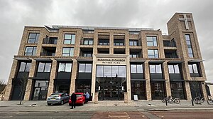
Dundonald Church
Church in London Borough of Merton, United Kingdom
Distance: Approx. 368 meters
Latitude and longitude: 51.4105,-0.222
Dundonald Church is an evangelical Church located in the Wimbledon area of the London Borough of Merton, London. In a new purpose built building in Raynes Park, Dundonald is committed to preaching the Bible in keeping with the Reformed Evangelical tradition known as Calvinism. Dundonald is a part of the Co-Mission Initiative, a church-planting network in London, which houses its offices in the Church building.
Weather in this IP's area
broken clouds
15 Celsius
15 Celsius
14 Celsius
16 Celsius
1023 hPa
85 %
1023 hPa
1020 hPa
10000 meters
3.6 m/s
40 degree
75 %
06:44:17
19:04:14