Country:
Region:
City:
Latitude and Longitude:
Time Zone:
Postal Code:
IP information under different IP Channel
ip-api
Country
Region
City
ASN
Time Zone
ISP
Blacklist
Proxy
Latitude
Longitude
Postal
Route
Luminati
Country
ASN
Time Zone
Europe/London
ISP
Iomart Cloud Services Limited
Latitude
Longitude
Postal
IPinfo
Country
Region
City
ASN
Time Zone
ISP
Blacklist
Proxy
Latitude
Longitude
Postal
Route
db-ip
Country
Region
City
ASN
Time Zone
ISP
Blacklist
Proxy
Latitude
Longitude
Postal
Route
ipdata
Country
Region
City
ASN
Time Zone
ISP
Blacklist
Proxy
Latitude
Longitude
Postal
Route
Popular places and events near this IP address

Roehampton
District in south-west London, England
Distance: Approx. 624 meters
Latitude and longitude: 51.451,-0.243
Roehampton is an area in southwest London, in the Putney SW15 postal district, and takes up a far western strip, running north to south, in the London Borough of Wandsworth. It contains a number of large council house estates and is home to the University of Roehampton.
University of Roehampton
University in England
Distance: Approx. 298 meters
Latitude and longitude: 51.4566,-0.2431
The University of Roehampton, London, formerly Roehampton Institute of Higher Education, is a public university in the United Kingdom, situated on three major sites in Roehampton, in the London Borough of Wandsworth. The University traces its roots to four institutions founded in the 19th century, which today make up the university's constituent colleges, around which student accommodation is centred: Digby Stuart College, Froebel College, Southlands College and Whitelands College. Between 2000 and 2004, Roehampton, together with the University of Surrey, partnered as the Federal University of Surrey.
Froebel College
Distance: Approx. 492 meters
Latitude and longitude: 51.4557,-0.246
Froebel College is one of the four constituent colleges of the University of Roehampton.

Queen Mary's Hospital, Roehampton
Hospital in Roehampton, England, United Kingdom
Distance: Approx. 240 meters
Latitude and longitude: 51.4553,-0.2422
Queen Mary's Hospital, formerly Queen Mary's Convalescent Auxiliary Hospitals, is a community hospital in Roehampton in the London Borough of Wandsworth. It is run by St George's University Hospitals NHS Foundation Trust.
Digby Stuart College
College at the University of Roehampton
Distance: Approx. 298 meters
Latitude and longitude: 51.4566,-0.2431
Digby Stuart College is one of the four constituent colleges of the University of Roehampton.
King's Head, Roehampton
Pub in Roehampton, London
Distance: Approx. 649 meters
Latitude and longitude: 51.450283,-0.240766
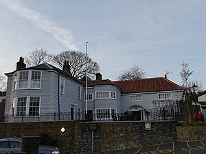
The King's Head is a Grade II listed public house at 1 Roehampton High Street, Roehampton, London SW15 4HL. It dates back to the 17th century, although altered and extended since then.
Roehampton House
Grade I listed building in the United Kingdom
Distance: Approx. 324 meters
Latitude and longitude: 51.454141,-0.2425176
Roehampton House is a Grade I listed house at Roehampton Lane, Roehampton, London. What is now the central block of the current building was built between 1710 and 1712 by the architect Thomas Archer and named Roehampton House. It was built on behalf of the merchant Thomas Cary.

Grove House, Roehampton
Distance: Approx. 478 meters
Latitude and longitude: 51.455087,-0.24564784
Grove House is a Grade II* listed house at Roehampton Lane, Roehampton, London. It was built in 1777 by James Wyatt for Sir Joshua Vanneck, but has later alterations and additions. It is part of Froebel College, University of Roehampton.
Putney Park House
Distance: Approx. 493 meters
Latitude and longitude: 51.460292,-0.23714225
Putney Park House is a Grade II listed house at 69 Pleasance Road, Roehampton, London. It was built in 1837–38 by the architect Decimus Burton for Robert Hutton.

Southlands College, Roehampton
Distance: Approx. 516 meters
Latitude and longitude: 51.4595,-0.2438
Southlands College, in Roehampton in the London Borough of Wandsworth, is one of four colleges at the University of Roehampton and is the location of the University's Business School and its Department of Media, Culture and Language. It was established by the Methodist Church in 1872, originally in Battersea, as a teacher training college for women and became coeducational in 1965. In 1975, the college became part of the Roehampton Institute of Higher Education, which became Roehampton University in 2004.

St Margaret's Church, Putney
Church in London, England
Distance: Approx. 464 meters
Latitude and longitude: 51.4591,-0.234439
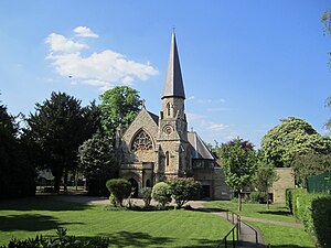
St Margaret's, Putney is situated in Putney Park Lane, Putney, London, England. It was designed by W. Allen Dixon in 1872. Prior to its dedication to St Margaret as an Anglican church it was first a Baptist and then a Presbyterian chapel under the name of Granard Chapel.

Dover House Estate
Housing estate in London
Distance: Approx. 526 meters
Latitude and longitude: 51.4607,-0.2397
Dover House Estate is one of a number of important London County Council cottage estates inspired by the Garden city movement. The land was previously the estates of two large houses, Dover House and Putney Park House, which were purchased by the London County Council soon after World War I. Dover House was demolished for the new estate, but Putney Park House remains.
Weather in this IP's area
overcast clouds
7 Celsius
7 Celsius
6 Celsius
8 Celsius
1026 hPa
79 %
1026 hPa
1021 hPa
10000 meters
1.03 m/s
50 degree
100 %
07:08:59
16:20:43


