Country:
 Great Britain
Region:
City:
Latitude and Longitude:
Time Zone:
Postal Code:
IP information under different IP Channel
ip-api
Country
Region
City
ASN
Time Zone
ISP
Blacklist
Proxy
Latitude
Longitude
Postal
Route
IPinfo
Country
Region
City
ASN
Time Zone
ISP
Blacklist
Proxy
Latitude
Longitude
Postal
Route
MaxMind
Country
Region
City
ASN
Time Zone
ISP
Blacklist
Proxy
Latitude
Longitude
Postal
Route
Luminati
Country
GBASN
Time Zone
Europe/London
ISP
Iomart Cloud Services Limited
Latitude
Longitude
Postal
db-ip
Country
Region
City
ASN
Time Zone
ISP
Blacklist
Proxy
Latitude
Longitude
Postal
Route
ipdata
Country
Region
City
ASN
Time Zone
ISP
Blacklist
Proxy
Latitude
Longitude
Postal
Route
Popular places and events near this IP address
Maidenhead
Market town in England
Distance: Approx. 1106 meters
Latitude and longitude: 51.5217,-0.7177
Maidenhead is a market town in the Royal Borough of Windsor and Maidenhead in the county of Berkshire, England, on the southwestern bank of the River Thames. In the 2021 Census, it had an estimated population of 70,374 and forms part of the border with southern Buckinghamshire. The town is situated 27 miles (43 km) west of Charing Cross, London and 13 miles (21 km) east-northeast of the county town of Reading.

Furze Platt railway station
Railway station in the town of Maidenhead, Berkshire, England
Distance: Approx. 395 meters
Latitude and longitude: 51.53318889,-0.72865
Furze Platt railway station is a railway station in the town of Maidenhead, Berkshire, England. It is 1 mile 22 chains (2.1 km) down the line from Maidenhead station and 25 miles 41 chains (41.1 km) measured from London Paddington.
St Piran's (school)
Private preparatory day school in Maidenhead, Berkshire, England
Distance: Approx. 415 meters
Latitude and longitude: 51.528,-0.7322
St Piran's is a prep school located on Gringer Hill in Maidenhead, Berkshire, England. The school was known as Cordwalles School until 1919 and has been co-educational since the 1990s.
Holyport F.C.
Association football club in England
Distance: Approx. 1141 meters
Latitude and longitude: 51.53944444,-0.72138889
Holyport Football Club is a football club based in Holyport, near Maidenhead, England. They are currently members of the Combined Counties League Premier Division North and play at Summerleaze Village in Maidenhead.
Claires Court School
Private day school in Maidenhead, Berkshire, England
Distance: Approx. 685 meters
Latitude and longitude: 51.5244,-0.7317
Claires Court School is a 2–18 all-through private day school and sixth form in Maidenhead, Berkshire, England. As one of a small number of diamond schools located in the United Kingdom, it is unique in that while its nursery and sixth form are mixed, Juniors (primary) and Seniors (secondary) are single-sex, though as of 2023, the Juniors will begin to merge into fully coed over the course of the next six years.
Redroofs Theatre School
Part-time theatre school in Maidenhead, Berkshire, England
Distance: Approx. 1041 meters
Latitude and longitude: 51.52215,-0.73559
Redroofs Theatre School is an independent part-time theatre training school in Maidenhead, Berkshire, England. The school was established in 1947 in London and moved to Littlewick Green in 1964 into a house that was once the home of Ivor Novello. The school currently has two bases in Maidenhead, and two theatres in Littlewick Green and Ascot respectively.

St Mary's Church, Maidenhead
Church in England
Distance: Approx. 922 meters
Latitude and longitude: 51.5234,-0.7185
St Mary's Church is a conservative evangelical Church of England parish church in the centre of Maidenhead, England. It has a congregation of mixed ages and backgrounds.
Maidenhead Boyne Hill railway station
Former railway station in England
Distance: Approx. 843 meters
Latitude and longitude: 51.522382,-0.729408
Maidenhead Boyne Hill railway station was built by the Wycombe Railway to serve the western part of Maidenhead. It was opened in 1854 and closed in 1871.

Maidenhead Heritage Centre
Distance: Approx. 1029 meters
Latitude and longitude: 51.5218,-0.7195
Maidenhead Heritage Centre is a heritage centre and museum in the town of Maidenhead, Berkshire, England. Maidenhead Heritage Centre and Museum was founded in 1993. The centre presents the history of Maidenhead history from Roman times to the present.

St Luke's Church, Maidenhead
Church
Distance: Approx. 433 meters
Latitude and longitude: 51.52669,-0.72319
St Luke's Church is a Church of England parish church in Maidenhead in the English county of Berkshire.
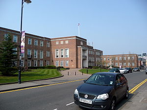
Maidenhead Town Hall
Municipal building in Maidenhead, Berkshire, England
Distance: Approx. 1049 meters
Latitude and longitude: 51.5219,-0.7187
Maidenhead Town Hall is a municipal building in St Ives Road, Maidenhead, Berkshire, England.

St Joseph's Church, Maidenhead
Church in Maidenhead, United Kingdom
Distance: Approx. 546 meters
Latitude and longitude: 51.5269,-0.7206
St Joseph's Church is a Roman Catholic parish church in Maidenhead, Berkshire, England. It was built in 1884 and designed by Leonard Stokes in the Gothic Revival style. It is located on the Cookham Road north of the town centre.
Weather in this IP's area
few clouds
16 Celsius
16 Celsius
15 Celsius
17 Celsius
1023 hPa
79 %
1023 hPa
1020 hPa
10000 meters
3.6 m/s
40 degree
20 %
06:44:42
19:08:37