Country:
Region:
City:
Latitude and Longitude:
Time Zone:
Postal Code:
IP information under different IP Channel
ip-api
Country
Region
City
ASN
Time Zone
ISP
Blacklist
Proxy
Latitude
Longitude
Postal
Route
Luminati
Country
ASN
Time Zone
Europe/London
ISP
Iomart Cloud Services Limited
Latitude
Longitude
Postal
IPinfo
Country
Region
City
ASN
Time Zone
ISP
Blacklist
Proxy
Latitude
Longitude
Postal
Route
db-ip
Country
Region
City
ASN
Time Zone
ISP
Blacklist
Proxy
Latitude
Longitude
Postal
Route
ipdata
Country
Region
City
ASN
Time Zone
ISP
Blacklist
Proxy
Latitude
Longitude
Postal
Route
Popular places and events near this IP address

Telegraph & Argus
Local newspaper in Bradford, England
Distance: Approx. 159 meters
Latitude and longitude: 53.79277778,-1.75055556
The Telegraph & Argus is the daily newspaper for Bradford, West Yorkshire, England. It is published six times each week, from Monday to Saturday inclusive. The newspaper has offices in Newhall Way, Bradford, from where its journalists work.

Wool Exchange, Bradford
Grade I listed building in Bradford, England
Distance: Approx. 47 meters
Latitude and longitude: 53.7943,-1.7523
The Wool Exchange Building in Bradford, West Yorkshire, England is a grade I-listed building built as a wool-trading centre in the 19th century. The grandeur of its Gothic Revival architecture is symbolic of the wealth and importance that wool brought to Bradford. Today it is a Waterstones bookshop as well as a cafe.

City (ward)
Human settlement in the United Kingdom
Distance: Approx. 71 meters
Latitude and longitude: 53.794,-1.751
City is an electoral ward within the City of Bradford Metropolitan District Council. City covers the centre of Bradford within the inner ring road and the areas of Shearbridge, Lister Hills, Brown Royd, Dirk Hill, Little Horton Green and part of Lidget Green all to the west of the commercial centre. It is part of the Bradford West parliamentary constituency.

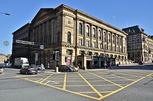
St George's Hall, Bradford
Concert hall in Bradford, West Yorkshire, England
Distance: Approx. 168 meters
Latitude and longitude: 53.7925,-1.7511
St George's Hall is a strategic grade II* listed Victorian building located in the centre of Bradford, West Yorkshire, England. Originally designed with a seating capacity of 3,500, the hall seats up to 1,335 people and 1,550 for standing concerts. It is one of the oldest concert halls still in use in the United Kingdom.

1858 Bradford sweets poisoning
Mass arsenic poisoning in England
Distance: Approx. 229 meters
Latitude and longitude: 53.795,-1.755
In 1858 a batch of sweets in Bradford, England, was accidentally adulterated with poisonous arsenic trioxide. About five pounds (two kilograms) of sweets were sold to the public, leading to around 20 deaths and over 200 people suffering the effects of arsenic poisoning. The adulteration of food had been practised in Britain since before the Middle Ages, but from 1800, with increasing urbanisation and the rise in shop-purchased food, adulterants became a growing problem.
Swan Arcade, Bradford
Distance: Approx. 100 meters
Latitude and longitude: 53.793,-1.752
The Swan Arcade was a four-storey building located between Market Street and Broadway, Bradford, England and stood opposite the Wool Exchange. The Bradford Beck ran beneath.

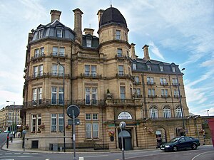
Midland Hotel, Bradford
Distance: Approx. 157 meters
Latitude and longitude: 53.7953,-1.7518
The Midland Hotel is a 90-bedroom three-star Victorian hotel in Bradford city centre, owned and managed by Britannia Hotels. The architect was Charles Trubshaw, who was contracted to design many railway stations for Midland Railway Company. Construction of the hotel began in 1885 and took five years to complete.

The Broadway, Bradford
Shopping mall in Bradford, England
Distance: Approx. 169 meters
Latitude and longitude: 53.7945,-1.7497
The Broadway is a shopping and leisure complex in the centre of Bradford, West Yorkshire, England, which opened on 5 November 2015. It was built and was operated, in its first year, by the Westfield Corporation but is owned by New River. It is currently operated by Munroe K Asset Management Ltd.

Bradford City Hall
Municipal building in Bradford, West Yorkshire, England
Distance: Approx. 196 meters
Latitude and longitude: 53.7923,-1.7533
Bradford City Hall is a 19th-century town hall in Centenary Square, Bradford, West Yorkshire, England. It is a Grade I listed building which has a distinctive clock tower.
Bradford City Park
West Yorkshire public area
Distance: Approx. 204 meters
Latitude and longitude: 53.7926,-1.75425
City Park is a public space in the centre of Bradford, West Yorkshire. It is centred on the Grade I listed Bradford City Hall. The city park comprises three main areas (each side of the triangular City Hall site.) To the east of the City Hall is the Norfolk Gardens area.

Sunbridge Wells
Leisure and shopping facility and tourist attraction in West Yorkshire, England
Distance: Approx. 222 meters
Latitude and longitude: 53.79358333,-1.75538889
Sunbridge Wells is a leisure and shopping facility and tourist attraction built in tunnels in Bradford, West Yorkshire, England. The centre was opened in 2016.

Bradford Law Courts
Judicial building in Bradford, England
Distance: Approx. 231 meters
Latitude and longitude: 53.7927,-1.7492
The Bradford Law Courts is a Crown Court venue, which deals with criminal cases, as well as a County Court venue, which deals with civil cases, at Exchange Square, off Drake Street, Bradford, England.
Weather in this IP's area
broken clouds
7 Celsius
5 Celsius
6 Celsius
8 Celsius
1025 hPa
90 %
1025 hPa
1010 hPa
6000 meters
3.09 m/s
250 degree
75 %
07:23:05
16:18:43
