Country:
 Great Britain
Region:
City:
Latitude and Longitude:
Time Zone:
Postal Code:
IP information under different IP Channel
ip-api
Country
Region
City
ASN
Time Zone
ISP
Blacklist
Proxy
Latitude
Longitude
Postal
Route
IPinfo
Country
Region
City
ASN
Time Zone
ISP
Blacklist
Proxy
Latitude
Longitude
Postal
Route
MaxMind
Country
Region
City
ASN
Time Zone
ISP
Blacklist
Proxy
Latitude
Longitude
Postal
Route
Luminati
Country
GBASN
Time Zone
Europe/London
ISP
Iomart Cloud Services Limited
Latitude
Longitude
Postal
db-ip
Country
Region
City
ASN
Time Zone
ISP
Blacklist
Proxy
Latitude
Longitude
Postal
Route
ipdata
Country
Region
City
ASN
Time Zone
ISP
Blacklist
Proxy
Latitude
Longitude
Postal
Route
Popular places and events near this IP address
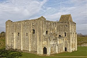
Castle Rising Castle
12th-century castle in Norfolk, England
Distance: Approx. 2618 meters
Latitude and longitude: 52.7928,0.4689
Castle Rising is a ruined medieval fortification in the village of Castle Rising, Norfolk, England. It was built soon after 1138 by William d'Aubigny II, who had risen through the ranks of the Anglo-Norman nobility to become the Earl of Arundel. With his new wealth, he constructed Castle Rising and its surrounding deer park, a combination of fortress and palatial hunting lodge.

Queen Elizabeth Hospital, King's Lynn
Hospital in Norfolk, England
Distance: Approx. 3114 meters
Latitude and longitude: 52.7566,0.4471
Queen Elizabeth Hospital in King's Lynn, Norfolk, England. It is located on the outskirts of King's Lynn, to the eastern edge of the town. The catchment area of the Queen Elizabeth Hospital covers the West Norfolk area, South Lincolnshire and Northern part of Fenland District, Cambridgeshire, an area of approximately 1500 km2 and 250,000 people.

Castle Rising
Village and civil parish in Norfolk, England
Distance: Approx. 2627 meters
Latitude and longitude: 52.7929393,0.4689556
Castle Rising is a village and civil parish in the English county of Norfolk. The village is situated some 8 kilometres (5 mi) north-east of the town of King's Lynn and 60 kilometres (37 mi) west of the city of Norwich. The River Babingley skirts the north of the village separating Castle Rising from the site of the lost village of Babingley.

South Wootton
Human settlement in England
Distance: Approx. 758 meters
Latitude and longitude: 52.77944,0.4426
South Wootton is a village and civil parish in the English county of Norfolk, approximately 2 miles (3.2 km) north-east of King's Lynn. It covers an area of 8.54 km2 (3.30 sq mi) and had a population of 3,717 in 1,450 households at the 2001 Census, increasing at the 2011 Census to a population of 4,247 in 1,696 households. For the purposes of local government, it falls within the District of King's Lynn and West Norfolk.

North Wootton, Norfolk
Human settlement in England
Distance: Approx. 40 meters
Latitude and longitude: 52.783,0.433
North Wootton is a village, civil parish and electoral ward near the town of King's Lynn in Norfolk, England. It covers an area of 32.33 km2 (12.48 sq mi) and had a population of 2,387 in 935 households at the 2001 census, the population including Babingley and increasing to 2,445 at the 2011 Census. For the purposes of local government, it falls within the district of King's Lynn and West Norfolk.

North Lynn
Human settlement in England
Distance: Approx. 2454 meters
Latitude and longitude: 52.765,0.413
North Lynn is an urban residential area of King's Lynn, in the King's Lynn and West Norfolk district, in the county of Norfolk, England. There are three main parks in North Lynn: Peck's field (named after the previous owner of the land before the North Lynn estate was created), The Rec (RECreation Ground) and Colombia Park. North Lynn has one junior school, one primary school and one infant school, respectively: St Edmund's Junior School, St Edmund's (Foundation Community) Primary School, and Highgate Infant School.

King Edward VII Academy
Academy in King's Lynn, Norfolk, England
Distance: Approx. 3240 meters
Latitude and longitude: 52.75676,0.41359
King Edward VII Academy (known as KES Academy) is a large, mixed comprehensive secondary school in Gaywood Road (A148), King's Lynn, Norfolk, England with around 1,300 pupils, including about 300 in sixth form education. Prior to the school year beginning in September 1979, KES was an all-boys state grammar school. The school became an academy sponsored by the College of West Anglia's CWA Academy Trust in September 2014, but, following the college's withdrawal from school sponsorship in the summer of 2017, it became part of the Eastern Multi-academy Trust.

Gaywood, Norfolk
Human settlement in England
Distance: Approx. 3133 meters
Latitude and longitude: 52.756,0.422
Gaywood is an eastern suburb of King's Lynn, in the King's Lynn and West Norfolk district of Norfolk, England. Previously a civil parish in Freebridge Lynn Rural District, Gaywood became part of the borough of King's Lynn in 1935. Gaywood Hall, the seat of the Bagge baronets in the late nineteenth and early twentieth centuries, was built on the site of a mediaeval palace of a Bishop of Norwich, John de Gray.
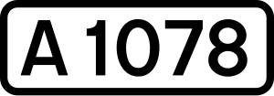
A1078 road
Road in Norfolk, England
Distance: Approx. 2361 meters
Latitude and longitude: 52.7704,0.4055
The A1078 is an English A road entirely in the county of Norfolk. It runs from a junction with the A148 King's Lynn to Cromer Road in the town of King's Lynn to a junction with the A148 King's Lynn to Cromer in the northern suburbs of King's Lynn. The road is an essential part of the transport infrastructure of King's Lynn as it links King's Lynn Docks and its industrial estates to the A149 Queen Elizabeth Way (King's Lynn Southern Bypass), allowing HGV traffic to reach the A47 main trunk road without passing through the centre of King's Lynn.

North Wootton railway station
Former railway station in Norfolk, England
Distance: Approx. 1038 meters
Latitude and longitude: 52.792,0.4278
North Wootton was a railway station on the King's Lynn to Hunstanton line which opened in 1862 to serve the village of North Wootton on the outskirts of King's Lynn in Norfolk, England. The station closed along with the line in 1969.

Springwood High School, King's Lynn
Academy in King's Lynn, Norfolk, England
Distance: Approx. 2505 meters
Latitude and longitude: 52.7608,0.433
Springwood High School is a secondary school with academy status in the town of King's Lynn in Norfolk, England. It was formed by the merger of several schools when the government began to abolish the tripartite system in the mid-1960s. Springwood has over 1700 pupils, including a Sixth Form with over 300 pupils and has been designated a Specialist Performing Arts College.

Grimston Warren Pit
Protected area in Norfolk, England
Distance: Approx. 3366 meters
Latitude and longitude: 52.771,0.479
Grimston Warren Pit is a 6.6-hectare (16-acre) geological Site of Special Scientific Interest east of King's Lynn in Norfolk. It is a Geological Conservation Review site. This former quarry is described by Natural England as "a nationally important site for dating the constituent facies of the Lower Cretaceous in north Norfolk".
Weather in this IP's area
overcast clouds
16 Celsius
16 Celsius
16 Celsius
16 Celsius
1025 hPa
86 %
1025 hPa
1024 hPa
8000 meters
5.14 m/s
40 degree
100 %
06:39:35
19:04:26