Country:
 Great Britain
Region:
City:
Latitude and Longitude:
Time Zone:
Postal Code:
IP information under different IP Channel
ip-api
Country
Region
City
ASN
Time Zone
ISP
Blacklist
Proxy
Latitude
Longitude
Postal
Route
IPinfo
Country
Region
City
ASN
Time Zone
ISP
Blacklist
Proxy
Latitude
Longitude
Postal
Route
MaxMind
Country
Region
City
ASN
Time Zone
ISP
Blacklist
Proxy
Latitude
Longitude
Postal
Route
Luminati
Country
GBASN
Time Zone
Europe/London
ISP
Iomart Cloud Services Limited
Latitude
Longitude
Postal
db-ip
Country
Region
City
ASN
Time Zone
ISP
Blacklist
Proxy
Latitude
Longitude
Postal
Route
ipdata
Country
Region
City
ASN
Time Zone
ISP
Blacklist
Proxy
Latitude
Longitude
Postal
Route
Popular places and events near this IP address

Leicester Cathedral
Cathedral in Leicester, England
Distance: Approx. 309 meters
Latitude and longitude: 52.634644,-1.137086
The Cathedral Church of Saint Martin, Leicester, commonly known as Leicester Cathedral, is a Church of England cathedral in Leicester, England and the seat of the Bishop of Leicester. The church was elevated to a collegiate church in 1922 and made a cathedral in 1927 following the establishment of a new Diocese of Leicester in 1926. The remains of King Richard III were reburied in the cathedral in 2015 after being discovered nearby in the foundations of the lost Greyfriars chapel, 530 years after his death.

Highcross Leicester
Shopping mall in Leicester, England
Distance: Approx. 290 meters
Latitude and longitude: 52.63638889,-1.13555556
Highcross Leicester is a shopping centre in Leicester, England. It was opened as The Shires in 1991 to supplement the Haymarket Shopping Centre, also since re-developed. It was built on a central location within the city centre on Eastgates and High Street.

Jewry Wall
Ruined wall in Leicester, England
Distance: Approx. 248 meters
Latitude and longitude: 52.63491944,-1.141425
The Jewry Wall is a substantial ruined wall of 2nd-century Roman masonry, with two large archways, in Leicester, England. It stands alongside St Nicholas' Circle and St Nicholas' Church. It formed the west wall of a public building in Ratae Corieltauvorum (Roman Leicester), alongside public baths, the foundations of which were excavated in the 1930s and are also open to view.

BBC Radio Leicester
Radio station in Leicester
Distance: Approx. 243 meters
Latitude and longitude: 52.635,-1.138
BBC Radio Leicester is the BBC's local radio station serving the counties of Leicestershire and Rutland. It broadcasts on FM, DAB, digital TV and via BBC Sounds from studios at St Nicholas Place in Leicester. According to RAJAR, the station had a weekly audience of 106,000 listeners and a 3.9% share as of December 2023.
Diocese of Leicester
Diocese of the Church of England
Distance: Approx. 308 meters
Latitude and longitude: 52.6347,-1.137
The Diocese of Leicester is a Church of England diocese based in Leicester and including the current county of Leicestershire. The cathedral is Leicester Cathedral, where the Bishop of Leicester has his episcopal chair. The diocese is divided into two archdeaconries, the Archdeaconry of Leicester in the east of the county and the Archdeaconry of Loughborough in the west.

Leicester Central railway station
Former railway station in Leicester, England
Distance: Approx. 168 meters
Latitude and longitude: 52.6374,-1.1421
Leicester Central was a railway station in Leicester, England. It was situated to the west of the city centre, on Great Central Street which is today just off the inner ring road. It was closed in 1969.
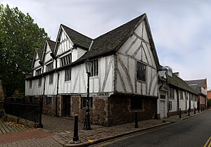
Leicester Guildhall
Municipal building in Leicester, Leicestershire, England
Distance: Approx. 282 meters
Latitude and longitude: 52.63469444,-1.13769444
The Guildhall in Leicester, England, is a timber framed building, with the earliest part dating from c. 1390. The Guildhall once acted as the town hall for the city until the current one was commissioned in 1876. It is located in the old walled city, on a street now known as Guildhall Lane.

St Nicholas Church, Leicester
Church
Distance: Approx. 210 meters
Latitude and longitude: 52.63514722,-1.14091389
St Nicholas Church is a Church of England parish church, and the oldest place of worship in Leicester, England.
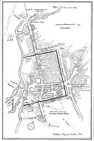
Ratae Corieltauvorum
Distance: Approx. 246 meters
Latitude and longitude: 52.6349,-1.1413
Ratae Corieltauvorum or simply Ratae was a town in the Roman province of Britannia. Today it is known as Leicester, located in the English county of Leicestershire.

All Saints Church, Leicester
Church in Leicester, England
Distance: Approx. 140 meters
Latitude and longitude: 52.6381,-1.1404
All Saints' Church is a redundant Anglican church in High Cross Street, Leicester, England. It is recorded in the National Heritage List for England as a designated Grade I listed building, and is under the care of the Churches Conservation Trust.

Jewry Wall Museum
Distance: Approx. 256 meters
Latitude and longitude: 52.634944,-1.141759
The Jewry Wall Museum is a museum in Leicester in the East Midlands of England. It was built in the 1960s, facing the Jewry Wall ruins in a building shared with Vaughan College. It housed artefacts from Iron Age, Roman, and medieval Leicester.
Leicester Vaughan College
Distance: Approx. 256 meters
Latitude and longitude: 52.634944,-1.141759
Leicester Vaughan College (LVC) is an independent higher education college in Leicester, England. It is the successor to Vaughan College, originally founded by Revd David Vaughan in 1862 to provide education for under-educated men. It rapidly became a facility for broader adult education and self-improvement for men and women of the town.
Weather in this IP's area
few clouds
14 Celsius
14 Celsius
14 Celsius
15 Celsius
1026 hPa
87 %
1026 hPa
1018 hPa
10000 meters
5 m/s
11.29 m/s
40 degree
18 %
06:45:56
19:10:40