Country:
 Great Britain
Region:
City:
Latitude and Longitude:
Time Zone:
Postal Code:
IP information under different IP Channel
ip-api
Country
Region
City
ASN
Time Zone
ISP
Blacklist
Proxy
Latitude
Longitude
Postal
Route
IPinfo
Country
Region
City
ASN
Time Zone
ISP
Blacklist
Proxy
Latitude
Longitude
Postal
Route
MaxMind
Country
Region
City
ASN
Time Zone
ISP
Blacklist
Proxy
Latitude
Longitude
Postal
Route
Luminati
Country
GBASN
Time Zone
Europe/London
ISP
Iomart Cloud Services Limited
Latitude
Longitude
Postal
db-ip
Country
Region
City
ASN
Time Zone
ISP
Blacklist
Proxy
Latitude
Longitude
Postal
Route
ipdata
Country
Region
City
ASN
Time Zone
ISP
Blacklist
Proxy
Latitude
Longitude
Postal
Route
Popular places and events near this IP address

Herne Bay
Town in Kent, England
Distance: Approx. 1306 meters
Latitude and longitude: 51.37,1.13
Herne Bay is a seaside town on the north coast of Kent in South East England. It is 6 miles (10 km) north of Canterbury and 4 miles (6 km) east of Whitstable. It neighbours the ancient villages of Herne and Reculver and is part of the City of Canterbury local government district, although it remains a separate town with countryside between it and Canterbury.

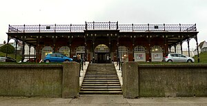
Herne Bay railway station
Railway station in Kent, England
Distance: Approx. 1171 meters
Latitude and longitude: 51.36449444,1.11781667
Herne Bay railway station is on the Chatham Main Line in England, serving the town of Herne Bay, Kent. It is 62 miles 58 chains (100.9 km) down the line from London Victoria and is situated between Chestfield & Swalecliffe and Birchington-on-Sea. The station and all trains that serve the station are operated by Southeastern.
Herne and Broomfield
Human settlement in England
Distance: Approx. 1020 meters
Latitude and longitude: 51.3492,1.1331
Herne and Broomfield is a civil parish and electoral ward within the City of Canterbury. The parish is situated to the north of Canterbury in Kent. The seaside town of Herne Bay is the other side of the A299 road, Thanet Way that marks the northern boundary of the parish.
Herne Bay F.C.
Association football club in England
Distance: Approx. 718 meters
Latitude and longitude: 51.36468333,1.12991111
Herne Bay Football Club is a football club based in Herne Bay, Kent, England. Affiliated to the Kent County Football Association, they are currently members of the Isthmian League South East Division and play at Winch's Field.
Herne, Kent
Village in South East England
Distance: Approx. 1020 meters
Latitude and longitude: 51.3492,1.1331
Herne is a village in the civil parish of Herne and Broomfield, in Canterbury district, in the county of Kent, England. It is divided by the Thanet Way from the seaside resort of Herne Bay. Between Herne and Broomfield, is the former hamlet of Hunters Forstal.

Herne Bay High School
Academy in Herne Bay, Kent, England
Distance: Approx. 1374 meters
Latitude and longitude: 51.3616,1.1124
Herne Bay High School is a mixed ability Academy, with designated Sports College status, situated in Herne Bay, Kent, England. There are 1506 students in the school aged 11 to 18. The principal as of March 2022 is Mr Jon Boyes.
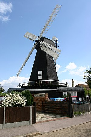
Herne Windmill
Listed building in Kent, England
Distance: Approx. 510 meters
Latitude and longitude: 51.35527778,1.13694444
Herne Windmill is a Grade I listed smock mill in Herne, Kent, England, that was built in 1789.

Herne Bay Museum and Gallery
Local history museum, history of the seaside, art gallery, heritage centre in Herne Bay, Kent
Distance: Approx. 1236 meters
Latitude and longitude: 51.36916667,1.12777778
The Seaside Museum Herne Bay is a local museum in Herne Bay, Kent, England. It was established in 1932, (as the Herne Bay Museum) and is notable for being a seaside tourist attraction featuring local archaeological and social history, for featuring the history of the town as a tourist resort, for its local art exhibitions and for its World War II bouncing bomb. The management of the Museum was awarded by Canterbury City Council to the Herne Bay Museum Trust, who reopened it in July 2015, as The Seaside Museum Herne Bay.
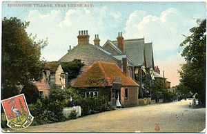
Eddington, Kent
Human settlement in England
Distance: Approx. 515 meters
Latitude and longitude: 51.362,1.127
Eddington was a village in Kent, South East England to the south-east of Herne Bay, to the west of Beltinge and to the north of Herne. It is now a suburb of Herne Bay, in Greenhill and Eddington Ward, one of the five wards of Herne Bay. Its main landmark for over 100 years until 2010 was Herne Bay Court, a former school which once possessed one of the largest and best-equipped school engineering workshops in England; it later became a Christian conference centre.

Central Bandstand, Herne Bay
Performance venue in Kent, United Kingdom
Distance: Approx. 1670 meters
Latitude and longitude: 51.3726,1.1242
The Central Bandstand, known as the Bandstand, in Herne Bay, Kent, England, was designed by H. Kempton Dyson in 1924, extended with an art deco frontage in 1932, and refurbished between 1998 and 1999. It is one of the coastal landmarks of the town. When first built, it was a popular venue for visiting military band concerts and for tea dances.
King's Hall, Herne Bay
Concert hall in Herne Bay, Kent, England
Distance: Approx. 1655 meters
Latitude and longitude: 51.3728,1.1367
The King's Hall is a theatre, concert hall and dance hall at Herne Bay, Kent, England. It was built as The Pavilion in 1903–1904, developed as the King Edward VII Memorial Hall in 1913 in memory of the late king, and was being called The King's Hall by 1912 while still at planning stage. Both building phases were designed by the local Council surveyor F.W.J. Palmer, CE. The year 2013 was the centenary of the completion of the second and final phase of this building and its grand opening by Princess Beatrice on 10 July 1913.
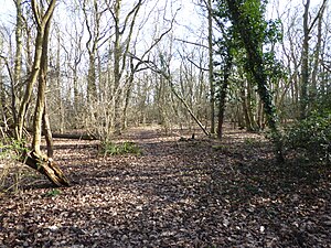
Curtis Wood
Nature reserve in Kent, England
Distance: Approx. 1512 meters
Latitude and longitude: 51.345,1.127
Curtis Wood is a 5.3-hectare (13-acre) Local Nature Reserve in Herne in Kent. It is owned and managed by Canterbury City Council. This wood has diverse ground flora including early purple and greater butterfly orchids.
Weather in this IP's area
clear sky
18 Celsius
18 Celsius
16 Celsius
18 Celsius
1021 hPa
92 %
1021 hPa
1018 hPa
10000 meters
2.24 m/s
4.47 m/s
46 degree
2 %
06:38:53
18:58:49