109.163.196.109 - IP Lookup: Free IP Address Lookup, Postal Code Lookup, IP Location Lookup, IP ASN, Public IP
Country:
Region:
City:
Location:
Time Zone:
Postal Code:
ISP:
ASN:
language:
User-Agent:
Proxy IP:
Blacklist:
IP information under different IP Channel
ip-api
Country
Region
City
ASN
Time Zone
ISP
Blacklist
Proxy
Latitude
Longitude
Postal
Route
db-ip
Country
Region
City
ASN
Time Zone
ISP
Blacklist
Proxy
Latitude
Longitude
Postal
Route
IPinfo
Country
Region
City
ASN
Time Zone
ISP
Blacklist
Proxy
Latitude
Longitude
Postal
Route
IP2Location
109.163.196.109Country
Region
abay oblysy
City
semey
Time Zone
Asia/Almaty
ISP
Language
User-Agent
Latitude
Longitude
Postal
ipdata
Country
Region
City
ASN
Time Zone
ISP
Blacklist
Proxy
Latitude
Longitude
Postal
Route
Popular places and events near this IP address

Semey
City in Abai Region, Kazakhstan
Distance: Approx. 3721 meters
Latitude and longitude: 50.43333333,80.26666667
Semey (; Kazakh: Семей / Semei [sʲɪˈmʲej] ()), formerly known as Semipalatinsk (Russian: Семипалатинск [sʲɪmʲɪpɐˈɫatʲɪnsk]) until 2007 and as Alash-Qala (Kazakh: Алаш-қала / Alaş-qala [ɑˌɫɑʃ‿qɑˈɫɑ]) from 1917 to 1920, is a city in eastern Kazakhstan, in the Kazakh part of Siberia. When Abai Region was created in 2022, Semey became its administrative centre. It lies along the Irtysh River near the border with Russia, 1,000 kilometers (620 mi) north of Almaty and 700 kilometers (430 mi) southeast of the Russian city of Omsk.

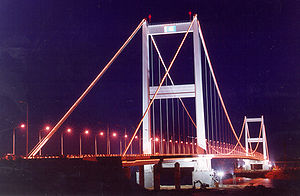
Semey Bridge
Bridge in Semey
Distance: Approx. 222 meters
Latitude and longitude: 50.4101,80.2248
The Semey Bridge (Kazakh: Semeı qalasyndaǵy aspaly kópir) is a gravity-anchored suspension bridge that crosses the Irtysh River in Semey, Kazakhstan. It has a main span of 750 meters and a total length of 1086 m. It was built between 1998 and 2001 and is currently in use by road traffic.
Semey Airport
Airport in Kazakhstan
Distance: Approx. 6665 meters
Latitude and longitude: 50.35138889,80.23444444
Semei International Airport (Kazakh: Semei Halyqaralyq Äuejaiy) (IATA: PLX, ICAO: UASS), formerly New Semei (Kazakh: Jañasemei) and named after Abai Qunanbaiuly, is an airport in Semei, Kazakhstan, located 10 km (6.2 mi) south-west of the city. It services large airliners. The airfield contains two groups of alert fighter pads.

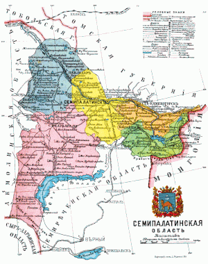
Semipalatinsk Oblast, Russia
Distance: Approx. 0 meters
Latitude and longitude: 50.4111,80.2275
The Semipalatinsk Oblast (Russian: Семипалатинская область) was an oblast (province) of the Russian Empire and the early Russian SFSR. From 1882 to 1917 it was part of the Governor-Generalship of the Steppes. It roughly corresponded to most of present-day northeastern Kazakhstan. It was created out of the territories of the former Kazakh Khanate.

Zhanasemey District
District in Abai Region, Kazakhstan
Distance: Approx. 1455 meters
Latitude and longitude: 50.4,80.21666667
Zhanasemey District (Kazakh: Жаңасемей ауданы, Russian: Жанасемейский район) is a district of Abai Region in eastern Kazakhstan. The administrative center is Semey city, although it is not part of the district.

Aeroflot Flight X-167
1973 aviation incident in the Soviet Union
Distance: Approx. 8695 meters
Latitude and longitude: 50.33305556,80.2225
Flight X-167 was a scheduled domestic passenger flight operated by Aeroflot from Semipalatinsk (now Semey) to Karaganda on February 28, 1973. The flight, conducted with a Yakovlev Yak-40 aircraft, ended in tragedy when the plane crashed shortly after takeoff, resulting in the deaths of all 32 occupants on board. The exact cause of the accident remains undetermined despite extensive investigation.

Museum of Fine Arts Named after the Nevzorov Family
Museum in Semey, Abai, Kazakhstan
Distance: Approx. 2111 meters
Latitude and longitude: 50.40191667,80.25352778
The Museum of Fine Arts Named after the Nevzorov Family (Kazakh: Невзоровтар отбасы атындағы бейнелеу өнері мұражайы) is an art museum in Semey, Abai Region, Kazakhstan.
Weather in this IP's area
overcast clouds
-10 Celsius
-14 Celsius
-10 Celsius
-10 Celsius
1023 hPa
93 %
1023 hPa
994 hPa
10000 meters
1.99 m/s
1.9 m/s
160 degree
100 %
